The Living Atlas of the World by Esri
Esri’s Living Atlas of the World
Esri’s Living Atlas of the World is the largest curation of authoritative maps, apps, and data from around the world.
You may not even know it. But if you have an Esri organizational account, then you are already sitting on a gold mine of data.
It’s “living” because it’s always being enhanced. Likewise, the data is always evolving with the introduction of new data layers.
Overall, there’s always something new and interesting with the Living Atlas of the World. Let’s find out more.
It’s all about the data
Something that people might not know about the Living Atlas of the World is that Esri owns just a small portion of the content.
Instead, it’s from contributors like the Census Bureau, Johns Hopkins, and millions more who participate in the curation of its data layers.
When you use a basemap like World Imagery or Hillshade from Esri, you are using the Living Atlas of the World. Here are some example themes and data layers that are part of it:
| Theme | Data Layers |
|---|---|
| Satellite/Aerial Imagery | Sentinel-2 views, world imagery, NAIP imagery, and multispectral imagery |
| Environment | SSURGO soils, land cover, forest types, protected areas, wetlands, and sea surface temperature |
| People | Unemployment, social vulnerability, COVID-19 cases, tapestry segmentation, and global human footprint |
| Infrastructure | World traffic, building footprints, and OpenStreetMap |
| Disasters | Wildfires, hurricanes, typhoons, earthquakes, and weather warnings |
| Elevation | Hillshade, terrain, ocean bathymetry, and world topographic map |
It’s all about the apps
The Living Atlas of the World is not just about the data. But it’s about how you can present the data or use it in a web application.
Because if you have decades of historical imagery, how useful would it be if you couldn’t view it all in a slick web app? Enter the World Imagery Wayback app which does exactly that.
Here are some of our other favorite apps that belong to the Living Atlas of the World.
World Imagery Wayback
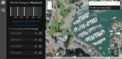
World Imagery Wayback App
Go backward and forward in time to choose the vintage of an image that you want to work with.
Topographic Map Explorer
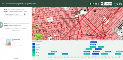
USGS Historical Topographic Map Explorer
View and download historical topographic maps from USGS.
Indicators of the Planet
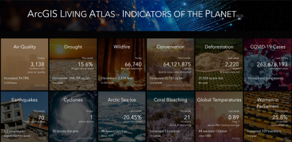
Indicators of the Planet
All the challenges that confront our planet rolled up into one dashboard-style app.
Landsat Explorer
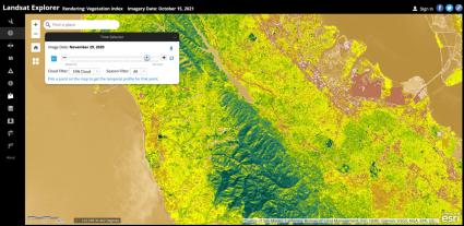
Landsat Explorer
Explore the different spectral bands and characteristics of Landsat.
Charted Territory
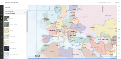
Charted Territory
An app that reminds you of a scholastic classroom wall-size map until you zoom into its beautiful hillshade relief.
Air Quality Aware
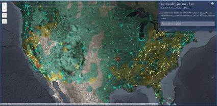
Air Quality Aware
Find information about the current conditions of air quality in the United States from the EPA.
It’s all about the maps
The Living Atlas of the World is not just about data. But it’s the fundamental layers that you can build authoritative maps from.
This means you can apply it anywhere. For instance, you can add data layers to Operational Dashboards, Story Maps, and Experience Builder.
We live in the information age and one of the consequences is that we are barraged with truckloads of data sources each day.
Fortunately, one of the easier ways to find the authoritative data source for your maps is by using the Living Atlas of the World.
Pricing
Although several apps from the Living Atlas of the World are available to access for free, data layers are available with your organizational account subscription with the Esri platform.


