Maptitude From Caliper (Review)
Maptitude Review
In a world where everyone is trying to work smarter (not harder), Maptitude is a legitimate contender to do exactly that. It merges the best of open source and commercial GIS all in one package.
Maptitude really stands out as one of the more affordable one-stop-shop GIS platforms on the market with a low learning curve. In this review, we’ll show you 5 reasons why Maptitude from Caliper stands out from the crowd.
Pros/Cons of Maptitude
Here are some of the advantages and disadvantages of using Maptitude compared to other GIS software applications.
PROS
CONS
Maptitude Ratings
Mapping
Analysis
Editing
Data Support
Ranked #12 from 30 GIS Software
1. Customize Your Maps with Intuitive Wizards
With an intuitive wizard-driven interface, using Maptitude is as natural as breathing.
Set up a wizard to create a thematic map by clicking File > New > Map.
The Create-a-Map Wizard gives you an intuitive way to create color, dot density, chart, scaled-symbol, and 3D prism maps without a lot of fuss.
Maptitude produces elegant maps that are completely customizable by the user.
…And if you need to go beyond wizards you can easily do so with a wealth of geospatial tools at your fingertips.
2. Optimize Your Business Needs
Where Maptitude really shines is in business analysis. It has all the tools and data that the majority of analysts require.
Companies that require balanced territory mapping can use Maptitude’s territory tool to maximize market potential. Through interactive selection, Maptitude tracks and balances as many territory characteristics as you want. This allows companies to better establish, justify, and defend profitable territories without over-representation in other locations.
Using Maptitude’s interactive wizard, businesses can balance out their population and generate sales territories:
Another interesting analysis is the Huff Gravity Model which can be performed in Maptitude. Given several store locations in an area, the Huff Model can illustrate the probability that consumers will frequent each store location.
Companies can better manage their sales, distribution, and coverage geographically, and integrate data such as demographics and corporate revenue.
3. Route Your Fleet with TransModeler and TransCAD
The routing manager and logistics features are also excellent tools. These tools ensure the flow of an efficient fleet to stay competitive. The route analysis tools optimize delivery routes and minimize logistics costs.

Poor transportation planning can be costly to an organization. For example, delivery crews often handle multiple stops, at varying speeds and with different/several rest stops. Maptitude uses sophisticated algorithms to handle these scenarios with a focus on time and energy efficiency. Using the Routing Manager to find and optimize the shortest routes, Maptitude can handle sophisticated route planning, even with routes that make multiple deliveries.
With Caliper’s other software programs being TransCAD and TransModeler (used for transportation planning and traffic simulation), it makes sense that Caliper is ideal for these types of geographic analyses. Maptitude is built with business and transportation location intelligence in mind.
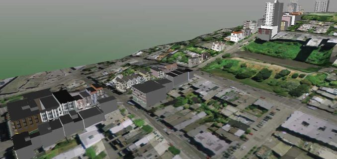
4. Display Powerful Visualizations
Maptitude can render 3D objects with stunning detail and pizzazz. Here is a piece of San Francisco in three dimensions.
Maptitude comes with seemingly endless ways to map data: heat maps, drive-time rings, flow maps, desire lines, spider maps, surface analysis, territory mapping, and trade area/site selection.
It also supports topological and geographic editing tools, extensive datum/projection/coordinate support, network analysis, customizable styles, labels and annotations, raster image registration and reprojection, and much more.
5. Out-of-the-Box Demographic Data
Maptitude is fully loaded with an arsenal of GIS data. From demographics to transportation, Maptitude ensures that you can start and end your journey into geospatial analysis with plenty of data.
There is no shortage of Maptitude tutorials available to you to help you hit the ground running.
Creating maps out-of-the-box is made even easier by the fact that Maptitude includes presentation-quality maps and free offline address-level geocoding.
Summary: Maptitude Review
While it’s true that Maptitude is a commercial grade, low-cost, professional GIS, for higher-level environmental and geoscientific analysis you might want to look elsewhere – SAGA GIS, QGIS, and ArcGIS Pro come to mind.
For companies who want to perform business analysis, optimize routing, and create some beautiful visualizations, Maptitude might be your saving grace.
Maptitude strikes the middle ground bringing GIS to those who have no idea what GIS means! And it gives you the capability to scale your GIS operations if you really want to.


Unfortunately, I am constantly bombarded with pop-ups indicating license issues. Apparently this program conflicts with a data processing application I use. I am needing to bother our IS folks on a regular basis just to use this program. And in total, they have probably spent 5+ hours with Caliper’s support.
Excellent review! In your conclusion you mention that “…for higher level environmental and geoscientific analysis you might want to look elsewhere – SAGA GIS, QGIS and Esri ArcGIS come to mind …”.
I teach ArcGIS and QGIS along with Maptitude and TransCAD. QGIS is quite good but has almost no network GIS capabilities. ArcGIS is the worst boondoggle of all! The network analyst is loosely coupled so that if you want to change a network you have to do it in ArcCatalog from scratch. GIS is about distance, topology, spatial grouping and display. On all four Caliper (makers of Maptitude, TransCAD, Transmodeler) excels …
For over two years now, on almost daily basis, Maptitude has been my GIS software and in my capacity as a logistics consultant I have all functionality that it takes to perform anything from simple visualisations to extensive analysis and network restructuring. High quality and actual HERE maps, a huge amount of tools and themes and easy to learn. On top of this several third party add-ins are available to add just the extra “logistics” touch to this great software.