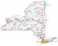
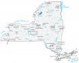
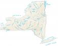
New York Lakes and Rivers Map

About the map
This map shows the major rivers, reservoirs, and lakes of New York. In general, rivers in New York flow into the Atlantic Ocean and the Great Lakes.
Whether it’s Lake Erie, Lake Ontario, or Lake Champlain, New York has over 7600 freshwater lakes, ponds, and reservoirs. For example, Finger Lakes is one of the prime recreation areas for New Yorkers. It consists of 11 narrow lakes and totals 133,480 acres in area.
Some of the major rivers in New York are the Hudson River, Delaware River, and Susquehanna River. New York’s boundary with Ontario, Canada is the St. Lawrence River. This river flows through cities like Montreal, Quebec City, and Trois-Riviere.
New York map collection
You are free to use our lakes and rivers map of New York for educational and commercial uses. Attribution is required. How to attribute?
New York lakes, rivers and reservoirs
Lakes and reservoirs
Lake Champlain
Oneida Lake
Lake Ontario
Lake Erie
Cayuga Lake
Seneca Lake
Lake George
Great Sacandaga Lake
Chatauqua Lake
Allegheny Reservoir
Canandaigua Lake
Skaneateles Lake
Pepacton Reservoir
Stillwater Reservoir
Cranberry Lake
Black Lake
Rivers and streams
Hudson River
Delaware River
Susquehanna River
Black River
Saranac River
Raquette River
Genesee River
Mohawk River
Erie Canal
Chemung River
St Lawrence River
Tonawanda Creek
Cattaraugus Creek
Canisteo River
Cohocton River
Chenang River
Wallkill River
Schoharie Creek
Hudson River
St Regis River
Water features
Atlantic Ocean
Long Island Sound
Thank You for the information on this site. I had no idea how many rivers and lakes are in this beautiful state of New York. It’s nice to know.