Planet Labs Imagery: The Entire Earth, Everyday
Planet Labs Imagery: The Entire Earth, Everyday
Planet Labs (or simply Planet) started with one main idea: To capture our dynamic Earth… Every day.
So how did they accomplish this feat?
The problem with most satellites is that they are large, clunky, and expensive to build. So Planet designed an ultra-compact, inexpensive one (CubeSat) which they could manufacture in bulk.
Over time, they have launched over 450+ doves (now known as Planetscope) into a single orbit plane. They scan each pole once every 90 minutes. As the Earth rotates, they collectively capture the entire Earth, every day.
Today you’re going to meet the satellite constellation that’s revolutionized how we see the Earth.
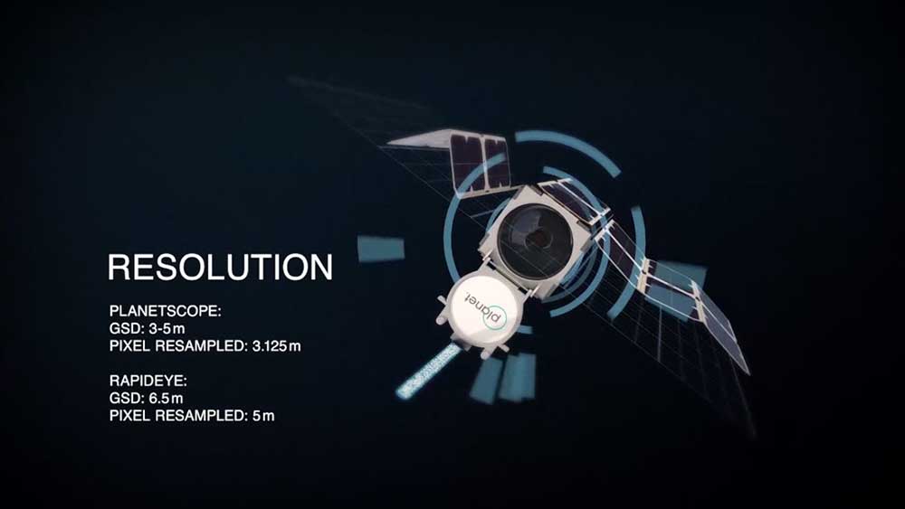
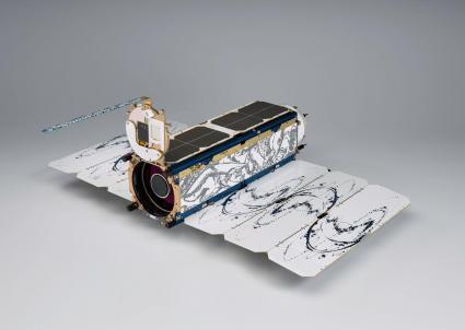
Planetscope and CubeSAT Design
Instead of Earth being static, it’s dynamic. And because the Earth is always changing, we need new innovative ways to look at it. From farming to retail to urban growth, there are hundreds of remote sensing applications in use today.
What’s special about the Planetscope fleet is its incredible temporal resolution. Because Planet’s fleet has grown to roughly 200, it can monitor anything and everything on Earth.
In 2015, Planet’s fleet began with a constellation of 67 doves within 4 separate launches. And again in 2015, it grew by another 42 dove satellites. Finally, Planet’s fleet is now orbiting over 450+ doves making it the largest constellation of Earth-imaging satellites in human history.
Here are the Planetscope specifications:
| Specification | Details |
|---|---|
| Spectral Resolution | 4 bands (RGB and NIR) |
| Spatial Resolution | 3 meters resolution (resampled) |
| Orthorectification | Orthorectified |
13 SkySAT and 5 RapidEye Satellites
The next chapter for Planet Labs belonged to two important acquisitions – RapidEye and SkySAT. And the acquisitions occurred simultaneously with the growth of its Planetscope fleet.
When Planet acquired RapidEye from BlackBridge, they now controlled a longer archive of Earth’s history. Dating back to 2009, you can actually dig deep into Planet’s 5-meter resolution RapidEye imagery archive. Overall, because of this archive expansion, now users can better understand Earth’s trends based on a longer historical period.
The next acquisition was the SkySAT satellite from Google’s Terra Bella. And this time, when Planet acquired SkySAT, this transformed its fleet into even higher resolution data (1 meter). Also, SkySAT gives the capabilities for a James Bond-style full-motion black-and-white video. Perfect for spies, or anyone who wants video footage from space.
Planet has a growing fleet. And it has revolutionized the satellite industry with an entirely different approach. Now that you have some background on Planet’s satellites, here’s how can you use Planet’s products.
Planet Explorer (Beta)
If you want to search, filter, and find imagery within an area of interest, then Planet’s Explorer Beta is your best option. This is one of the neatest satellite web viewers because of how it gives monthly previews. For example, in February, the snow cover dominates the North.
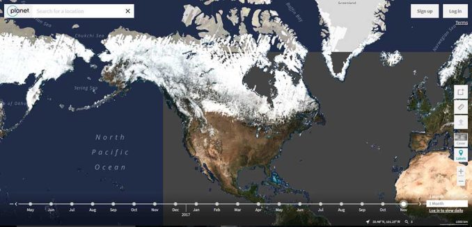
But in August, you can see how the snow recedes in the North
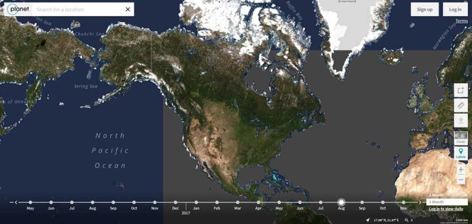
Okay, the changing of the seasons isn’t terribly interesting. I get it.
But the interesting thing is how many satellite scenes they’ve collected to make this happen! This map shows the number of scenes Planet has collected.
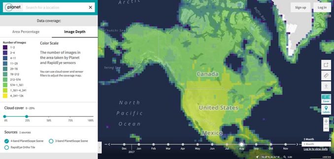
For example, most of the United States is in the range of 4k to 12k for scenes. That is a lot of satellite acquisitions!
Planet Basemaps
Long gone are the days when you actually physically need to download a copy of the data to your hard drive. Although I still love getting the raw data, Planet’s base maps integrate 1.5 million scenes daily in WGS84 Web Mercator.
There are also a couple of other neat features:
- Travel back in time with their basemap time-lapse and really get a glimpse of how things change in time.
- Programmatically search and download satellite imagery using Planet’s API.
- Enable email notifications for your AOI and wait for a notification in your inbox for the perfect, cloudless scene.
This means that you always have the most updated image of Earth for your maps.
PlanetScope satellite specifications:
Here are some of the specifications for the PlanetScope constellation and its technology
| Specification | Details |
|---|---|
| Satellite Constellation | PlanetScope |
| Launch Date | Various launches since 2013 |
| Orbit Altitude | Around 500 kilometers (310 miles) |
| Orbit Type | Sun-synchronous |
| Imaging Frequency | Daily revisits for most locations |
| Image Resolution | 3.7 meters (Panchromatic) 3.7 meters (Multispectral) |
| Spectral Bands | Blue, Green, Red, Near Infrared |
| Swath Width | 25 km (per image) |
| Data Products | RGB Images, Multipsectral Images, NDVI (Derived), Land Cover (Derived), etc. |
| Applications | Agriculture, Environmental Monitoring, Urban Planning, Disaster Response, etc. |
| Spectral Bands | Coastal Blue: 431 – 452 nm Blue: 465 – 515 nm Green I: 513 – 549 nm Green: 547 – 583 nm Yellow: 600 – 620 nm Red: 650 – 680 nm Red Edge: 697 – 713 nm NIR: 845 – 885 nm |
What’s next for Planet?
The use of satellite imagery for analytics is an untapped resource. You name it: the environment, agriculture, retail sales, oceanography, etc.
While companies like Maxar deliver more spectral bands, Planet takes a different approach. They offer an extraordinary amount of coverage almost as if it’s near real-time. I guess that’s why they are called “Planet” :)
So what direction will Planet take from here? Better spectral resolution? Stereo Imagery? Synthetic aperture radar (SAR)? Analytics?
It’s an exciting time in the world of remote sensing. No matter your field of study, take our list of remote sensing applications… and apply what you learn using satellite imagery like Planet Labs.


I think the analytics question is already answered. I use planet basemaps in Lens because they offer analytics too. There’s clear pricing on their website.
Does anyone know the pricing for a basic account?
The next big thing on Planet’s list is their SuperDove.
Lisa Craig, that is a great idea.
I would love a book of images capturing the planet during the covid-19 pandemic. Any plans for this please?
Sounds like a great idea. I haven’t heard of any