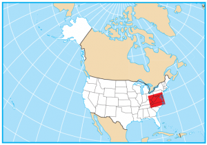
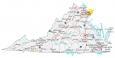
Virginia County Map and Independent Cities

About the map
This Virginia county map displays its 95 counties and 38 independent cities. Virginia’s tally of 133 administrative units makes it the third highest in the United States. Only Texas and Georgia have a higher count.
Other than Virginia, the states of Maryland, Missouri, and Nevada also have independent cities which are government units outside the jurisdiction of any county. For size, Pittsylvania County is the largest county in Virginia occupying an area of close to 1000 square miles. This county is located in the south of Virginia and shares a border with North Carolina.
Fairfax County has the highest population in Virginia with over 1.1 million residents. In fact, Fairfax County is the only county in Virginia that’s in the top 50 for the highest population. Whereas Highland County has the lowest population with just over 2000 people.
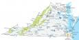
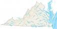
You are free to use our lakes and rivers map of Virginia for educational and commercial uses. Attribution is required. How to attribute?
Virginia County List
| FIPS Code | Name | Land (sq mi) | Water (sq mi) | Population (2024) |
|---|---|---|---|---|
| 51-001 | Accomack County | 449.3 | 860.7 | 33,411 |
| 51-003 | Albemarle County | 720.5 | 5.5 | 117,313 |
| 51-005 | Alleghany County | 446.6 | 3.2 | 14,632 |
| 51-007 | Amelia County | 355.3 | 3.3 | 13,716 |
| 51-009 | Amherst County | 474.0 | 5.0 | 31,650 |
| 51-011 | Appomattox County | 334.2 | 1.2 | 16,957 |
| 51-013 | Arlington County | 26.0 | 0.1 | 239,807 |
| 51-015 | Augusta County | 967.1 | 3.7 | 78,622 |
| 51-017 | Bath County | 529.2 | 5.4 | 4,071 |
| 51-019 | Bedford County | 760.1 | 16.3 | 82,182 |
| 51-021 | Bland County | 357.6 | 1.0 | 6,186 |
| 51-023 | Botetourt County | 541.3 | 4.7 | 34,129 |
| 51-025 | Brunswick County | 566.2 | 3.2 | 15,750 |
| 51-027 | Buchanan County | 502.9 | 1.1 | 18,632 |
| 51-029 | Buckingham County | 579.6 | 3.8 | 17,115 |
| 51-031 | Campbell County | 503.2 | 3.4 | 55,342 |
| 51-033 | Caroline County | 527.6 | 9.6 | 33,477 |
| 51-035 | Carroll County | 474.7 | 2.9 | 29,242 |
| 51-036 | Charles City County | 182.8 | 21.4 | 6,564 |
| 51-037 | Charlotte County | 475.3 | 2.2 | 11,258 |
| 51-041 | Chesterfield County | 423.6 | 13.4 | 389,793 |
| 51-043 | Clarke County | 175.9 | 2.2 | 15,598 |
| 51-045 | Craig County | 328.1 | 1.1 | 4,829 |
| 51-047 | Culpeper County | 379.2 | 3.5 | 56,125 |
| 51-049 | Cumberland County | 297.5 | 2.3 | 10,062 |
| 51-051 | Dickenson County | 330.4 | 3.1 | 13,411 |
| 51-053 | Dinwiddie County | 503.9 | 3.5 | 28,576 |
| 51-057 | Essex County | 257.1 | 28.9 | 10,683 |
| 51-059 | Fairfax County | 391.0 | 15.5 | 1,160,925 |
| 51-061 | Fauquier County | 648.0 | 3.7 | 75,865 |
| 51-063 | Floyd County | 380.9 | 0.8 | 15,658 |
| 51-065 | Fluvanna County | 287.1 | 4.1 | 28,746 |
| 51-067 | Franklin County | 690.6 | 21.0 | 55,637 |
| 51-069 | Frederick County | 413.2 | 2.3 | 98,109 |
| 51-071 | Giles County | 357.2 | 4.3 | 16,533 |
| 51-073 | Gloucester County | 217.8 | 70.2 | 40,154 |
| 51-075 | Goochland County | 280.6 | 8.5 | 28,223 |
| 51-077 | Grayson County | 441.8 | 3.8 | 15,265 |
| 51-079 | Greene County | 155.9 | 0.6 | 21,744 |
| 51-081 | Greensville County | 295.2 | 1.6 | 11,150 |
| 51-083 | Halifax County | 817.7 | 11.8 | 33,448 |
| 51-085 | Hanover County | 467.9 | 4.9 | 115,309 |
| 51-087 | Henrico County | 233.7 | 11.2 | 338,696 |
| 51-089 | Henry County | 382.3 | 2.0 | 49,385 |
| 51-091 | Highland County | 415.2 | 0.7 | 2,348 |
| 51-093 | Isle of Wight County | 315.7 | 47.2 | 40,942 |
| 51-095 | James City County | 142.4 | 36.8 | 82,797 |
| 51-097 | King and Queen County | 315.2 | 11.2 | 6,747 |
| 51-099 | King George County | 179.6 | 8.2 | 28,816 |
| 51-101 | King William County | 273.9 | 12.0 | 19,232 |
| 51-103 | Lancaster County | 133.3 | 98.1 | 11,062 |
| 51-105 | Lee County | 435.4 | 1.9 | 21,780 |
| 51-107 | Loudoun County | 515.8 | 5.6 | 443,380 |
| 51-109 | Louisa County | 496.1 | 14.6 | 42,109 |
| 51-111 | Lunenburg County | 431.7 | 0.7 | 12,060 |
| 51-113 | Madison County | 320.6 | 1.2 | 14,252 |
| 51-115 | Mathews County | 85.9 | 166.1 | 8,602 |
| 51-117 | Mecklenburg County | 625.3 | 53.9 | 30,824 |
| 51-119 | Middlesex County | 130.3 | 80.4 | 10,949 |
| 51-121 | Montgomery County | 386.8 | 2.4 | 98,998 |
| 51-125 | Nelson County | 470.7 | 3.5 | 14,766 |
| 51-127 | New Kent County | 210.0 | 13.7 | 27,218 |
| 51-131 | Northampton County | 211.7 | 583.6 | 12,004 |
| 51-133 | Northumberland County | 191.4 | 94.2 | 12,397 |
| 51-135 | Nottoway County | 314.4 | 1.7 | 15,632 |
| 51-137 | Orange County | 341.1 | 2.5 | 38,986 |
| 51-139 | Page County | 310.0 | 3.2 | 23,686 |
| 51-141 | Patrick County | 483.0 | 2.8 | 17,308 |
| 51-143 | Pittsylvania County | 969.0 | 9.2 | 59,410 |
| 51-145 | Powhatan County | 260.2 | 2.1 | 32,392 |
| 51-147 | Prince Edward County | 350.0 | 3.9 | 22,276 |
| 51-149 | Prince George County | 265.3 | 16.5 | 43,589 |
| 51-153 | Prince William County | 335.7 | 11.9 | 497,003 |
| 51-155 | Pulaski County | 319.8 | 9.6 | 33,579 |
| 51-157 | Rappahannock County | 266.4 | 0.8 | 7,479 |
| 51-159 | Richmond County | 191.5 | 24.9 | 9,215 |
| 51-161 | Roanoke County | 250.5 | 0.7 | 97,334 |
| 51-163 | Rockbridge County | 596.5 | 3.4 | 22,368 |
| 51-165 | Rockingham County | 849.8 | 4.1 | 87,674 |
| 51-167 | Russell County | 473.5 | 2.9 | 25,420 |
| 51-169 | Scott County | 535.8 | 3.1 | 21,388 |
| 51-171 | Shenandoah County | 508.1 | 3.8 | 45,441 |
| 51-173 | Smyth County | 451.3 | 1.4 | 29,137 |
| 51-175 | Southampton County | 599.2 | 3.1 | 17,941 |
| 51-177 | Spotsylvania County | 401.5 | 12.8 | 152,021 |
| 51-179 | Stafford County | 269.2 | 10.8 | 168,919 |
| 51-181 | Surry County | 278.9 | 31.4 | 6,579 |
| 51-183 | Sussex County | 490.2 | 2.6 | 10,753 |
| 51-185 | Tazewell County | 518.8 | 1.1 | 38,875 |
| 51-187 | Warren County | 214.5 | 3.3 | 42,461 |
| 51-191 | Washington County | 561.2 | 5.0 | 54,098 |
| 51-193 | Westmoreland County | 229.3 | 23.6 | 19,235 |
| 51-195 | Wise County | 403.4 | 2.0 | 34,973 |
| 51-197 | Wythe County | 461.9 | 2.8 | 28,100 |
| 51-199 | York County | 104.6 | 110.3 | 71,410 |
| 51-510 | Alexandria Independent City | 14.9 | 0.4 | 159,102 |
| 51-520 | Bristol Independent City | 12.9 | 0.1 | 16,316 |
| 51-530 | Buena Vista Independent City | 6.4 | 0.1 | 6,581 |
| 51-540 | Charlottesville Independent City | 10.2 | 0.0 | 44,767 |
| 51-550 | Chesapeake Independent City | 338.5 | 12.4 | 254,997 |
| 51-570 | Colonial Heights Independent City | 7.5 | 0.3 | 18,674 |
| 51-580 | Covington Independent City | 5.5 | 0.2 | 5,663 |
| 51-590 | Danville Independent City | 42.8 | 0.9 | 41,993 |
| 51-595 | Emporia Independent City | 6.9 | 0.1 | 5,402 |
| 51-600 | Fairfax Independent City | 6.2 | 0.0 | 26,340 |
| 51-610 | Falls Church Independent City | 2.0 | 0.0 | 15,034 |
| 51-620 | Franklin Independent City | 8.3 | 0.0 | 8,373 |
| 51-630 | Fredericksburg Independent City | 10.5 | 0.1 | 29,992 |
| 51-640 | Galax Independent City | 8.2 | 0.0 | 6,739 |
| 51-650 | Hampton Independent City | 51.4 | 84.8 | 137,596 |
| 51-660 | Harrisonburg Independent City | 17.3 | 0.1 | 51,164 |
| 51-670 | Hopewell Independent City | 10.4 | 0.5 | 22,970 |
| 51-678 | Lexington Independent City | 2.5 | 0.0 | 7,802 |
| 51-680 | Lynchburg Independent City | 49.0 | 0.6 | 80,301 |
| 51-683 | Manassas Independent City | 9.8 | 0.1 | 43,616 |
| 51-685 | Manassas Park Independent City | 2.5 | 0.0 | 16,611 |
| 51-690 | Martinsville Independent City | 11.0 | 0.1 | 13,834 |
| 51-700 | Newport News Independent City | 69.1 | 50.6 | 183,056 |
| 51-710 | Norfolk Independent City | 53.3 | 43.1 | 231,105 |
| 51-720 | Norton Independent City | 7.5 | 0.0 | 3,478 |
| 51-730 | Petersburg Independent City | 22.7 | 0.2 | 34,058 |
| 51-735 | Poquoson Independent City | 15.4 | 63.1 | 12,854 |
| 51-740 | Portsmouth Independent City | 33.3 | 13.4 | 96,482 |
| 51-750 | Radford Independent City | 9.7 | 0.3 | 17,273 |
| 51-760 | Richmond Independent City | 59.9 | 2.7 | 233,655 |
| 51-770 | Roanoke Independent City | 42.5 | 0.3 | 97,912 |
| 51-775 | Salem Independent City | 14.5 | 0.1 | 25,908 |
| 51-790 | Staunton Independent City | 19.9 | 0.1 | 26,361 |
| 51-800 | Suffolk Independent City | 399.2 | 29.8 | 103,105 |
| 51-810 | Virginia Beach Independent City | 244.7 | 252.8 | 454,808 |
| 51-820 | Waynesboro Independent City | 15.0 | 0.1 | 23,498 |
| 51-830 | Williamsburg Independent City | 8.9 | 0.2 | 16,030 |
| 51-840 | Winchester Independent City | 9.2 | 0.0 | 27,800 |
These are great maps for working on our home school projects. Is there a .pdf copy of the Virginia county map like there is for the other states?
Sorry, we don’t have PDFs. But I can point you to another resource with maps for each Virginia county and independent city – https://uscountymaps.com/virginia-county-map/