Datum Transformations – Converting Coordinates from NAD27 to NAD83
The importance of datum transformations
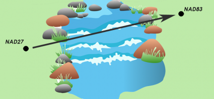
As the name implies, datum transformations transform your data from one datum to another.
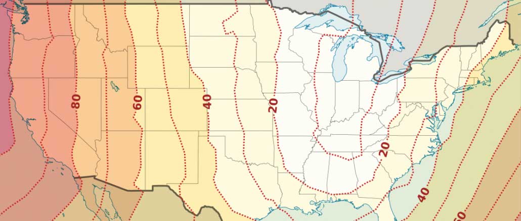
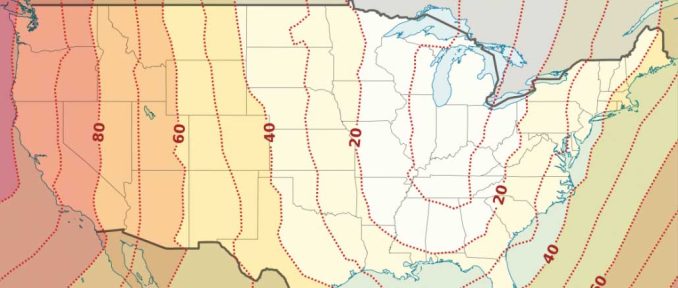
The latitude and longitude location in the NAD27 datum differs from NAD83 or WGS84. This difference is known as a datum shift.
Depending on where you are in North America, NAD27 and NAD83 may differ in tens of meters for horizontal accuracy. The average correction between NAD27 and NAD83 is an average of 0.349″ northward and 1.822″ eastward.
In this case, you would need to perform a datum transformation.
The history of datums
The first thing you should be careful of is that the physical locations have not changed. Most survey monuments have not moved.
Datum shifts happen because survey measurements improve, there are more of them, and methods of geodesy change.
This results in more accurate geodetic datums over time. The horizontal datums that form the basis of coordinates of all horizontal positions in North America improve.
Because we created maps using different geodetic datums throughout history, datum transformations are often necessary when using historical data. For example, USGS topographic maps generally were published using a NAD27 datum. You would have to perform a datum transformation if you’re using data in NAD83.
When do you need a datum transformation?
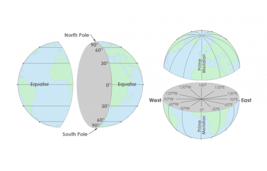
We reference all coordinates on Earth to a datum. A datum describes the shape of the Earth in mathematical terms. A datum defines the following parameters for an ellipsoid:
- Radius
- Inverse flattening
- Semi-major axis
- Semi-minor axis
The North American datum of 1983 (NAD83) is the current horizontal or geometric datum for the United States. It provides latitude and longitude and some height information.
Unfortunately, NAD83 is not the only datum you’ll encounter. Before the current datum was defined, many maps were created using different starting points. And even today, people continue to change geodetic datums to make them more accurate.
A common problem is when we store different coordinate locations in different reference systems. When combining data from different eras, you have to transform them into common geodetic datums.
Projected coordinate systems are based on geographic coordinates, which are in turn referenced to a datum. For example, the State Plane Coordinate System can be referenced to either NAD83 and NAD27 geodetic datums.
The NAD27 datum was based on the Clarke Ellipsoid of 1866:
- Semi-major axis: 6,378,206.4 m
- Semi-minor axis: 6,356,583.8 m
- Inverse flattening: 294.98
The NAD83 datum was based on the Geodetic Reference System (GRS80) Ellipsoid:
- Semi-major axis: 6,378,137.0 m
- Semi-minor axis: 6,356,752.3 m
- Inverse flattening: 298.26
What is a datum transformation?
For any type of work where coordinates need to be consistent with each other, you must use the same geodetic datum. If you are marking property boundaries or building a road, you must use the correct geodetic datums.
The challenge is to get points in different datums to align. After you get two sets of coordinated in a common datum, there are three steps to get them in alignment:
- Origin Alignment: Position the coordinates in close proximity
- Axis Rotation: Rotate the axis until coordinates align
- Scale Factor: Scale axes until coordinates match
Try for yourself
Remember next time in ArcMap when you use the “Project” tool…
When you transform NAD83 and NAD27 geographic coordinates to projected State Plane coordinates, it is the same projection method.
However, because the geodetic datums were different, the resulting projected coordinates will also be different.
In this case, a datum transformation is necessary. Be mindful of geographic transformations and how to choose the right one.


The Meades Ranch coordinates were FIXED at 39° 13′ 26.686″ north latitude and 98° 32′ 30.506″ west longitude. The site became a key marker for the US surveys. I cannot find however. any document which provides the details and methods used in determining those choices for the coordinates, especially any about fixing the longitude.
Speculation: I presume the longitude value was derived through timing intervals between astronomical transits viewed in London and at one (or more) US Observatory. The Dov at the Airy Transit Circle location has as its consequence, that now one should regard the WGS84 meridian as the effective meridian for the Airy telescope for transiting timing purposes. That is, the interval in timing between US and those from London should be considered as coming from a slightly greater longitudinal separation (than just from the Airy meridian itself). Of course, the intervals between the timings of transits in London and US also depended on their operators “personal equations” (Bessel).
Are there any documents extant, concerning the deliberations behind the adoption and the reasons how (earlier) and the final (fixed) Meades Ranch longitude was obtained?
Map Tools was a great little app and I used it quite a bit, especially for datum transforms. So convenient!!! Sad to see it disappear. I suspect the group that originated the app got bought out or has disbanded.
I once had an app on my iPhone called Map Tools which was a datum transformation tool. It was a purchased app but recently failed to update. I had previously found that it sometimes had to be deleted, reloaded to work. I work offshore and don’t always have a good internet connection with which to update my apps so I do that from good WiFi before departure. Having failed to recently update I delete them attempted to download again. But now I can’t find it when I search within my apps. Has anyone else used this app and experienced the same thing? I wonder if the developer of this app has folded andit’s no longer available. Can anyone recommend a good app for multiple datum transformations?
But where can I find the origin alignment, axis rotation, and scale information that will allow me to relate Clarke 1866, GRS80, and WGS84?