TerraPop Environmental & Demographic Data
What is TerraPop?
One of the common problems climate change scientists and others who study human and natural systems face today is understanding the interactions between population and environment.
Why?
Because our planet is complex. We need comparable data on a global scale for the human population, land use, land cover, and climate. On top of that, we need a deeper understanding of how space changes with time.
As we’re about to show, TerraPop can help better understand this complex problem through its harmonized data.
But you don’t need to be a scientist to understand how to use it.
Environment, Demographic Data, and More
Before describing what TerraPop is…
We’re so excited about TerraPop that we’ve added it to our top 10 list of GIS data sources.
Now, what is it?
TerraPop or “Terra Populus” is the only system that incorporates and integrates census data from over 160 countries around the world. Also, it includes environmental data describing land cover, land use, and climate.
From more than 80 countries around the world, the census data in TerraPop include individual and household-level records. And the aggregate data spans up to six decades, from the 1960s to the present.
The unique thing about it is how it can be used to explore temporal and spatial changes. Not only researchers but everyone now has a tool to attain and investigate transformative changes in the human-environment system in geographic space.
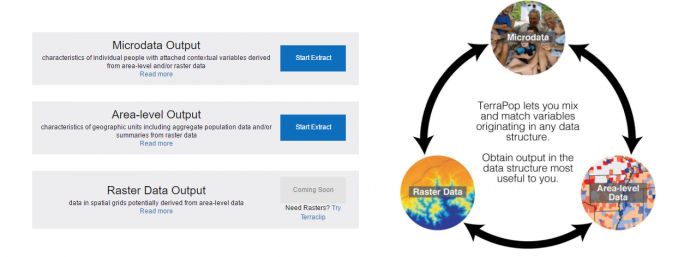
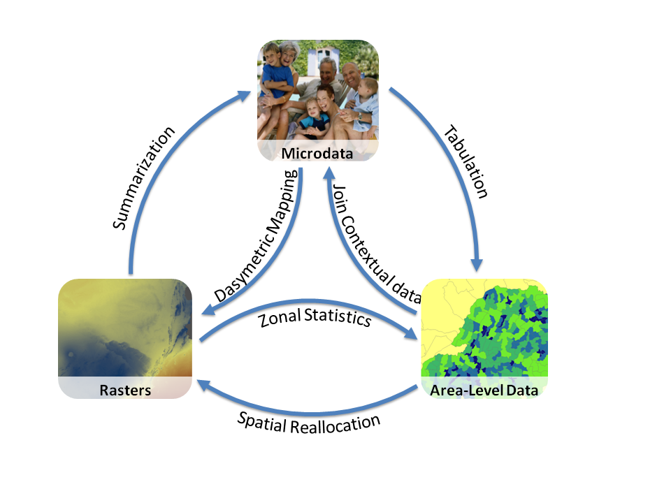
Area-level, Micro-data & Raster Data
TerraPop makes it possible for you to download big data in any of the three data structures workflows: area-level, raster, and micro-data.
AREA-LEVEL DATA characterizes a variable by some type of boundaries like provinces or municipalities. For example, it includes unemployment rates, education, and demographic data. Thanks to TerraPop’s unique data integration capabilities, area-level extracts may include population and environmental information summarized from raster data or tabulated from micro-data.
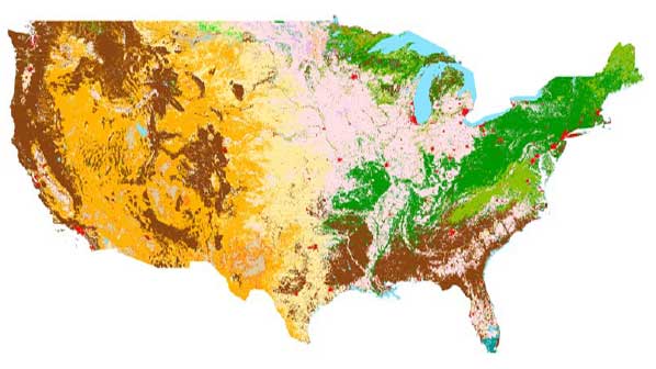
RASTER DATA shows how population and environmental characteristics vary by dividing space into a regular grid and recording a value for each cell in the grid (examples: land cover, climate & agriculture). Raster extracts may also incorporate data derived from area-level data or tabulated microdata.
MICRODATA consists of anonymized individual records, including all the responses a person gave to the questions in a census or survey (examples: social, dwelling, and person characteristics). Microdata records can be enriched by adding contextual variables describing the place in which a person lives derived from area-level or raster data. To obtain non-U.S. microdata, you’ll need to justify how you intend to use it during registration to get access.
How to Extract Data from TerraPop
First, you’ll need to create an account by registering. It’s a pretty painless process to sign up.
Eventually, you will confirm your account and you are ready to start your own TerraPop customized data delivery. You can begin on the main page of the TerraPop website:

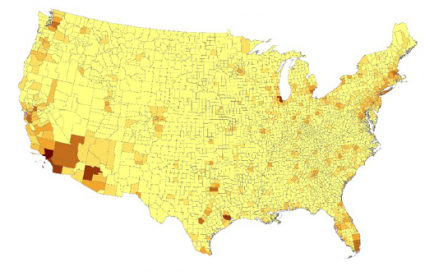
In this example, we will make an area-level extract. Now, click on Start Extract.
From here, you can browse through the different variables available such as birthplace, education, employment, household, urban, and demographic data – we’ve selected Unemployment Rates. Opposite to variables on the left, we chose the United States for geographic location on the right.
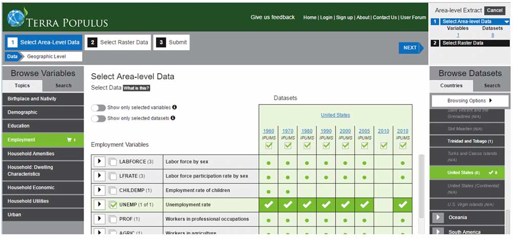
The next step is choosing your time frame and administrative level (lowest level available, 1st administrative level & national). To make your data consistent throughout, you select the Harmonized option:
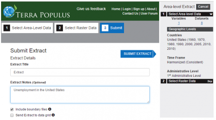
After clicking Next, you can give your extract a name. Finally, you can complete the extract by clicking the Submit button. Optionally, you can include the boundary file with the checkmark at the bottom.
Shortly after, you will get a link in your email to where you can download the extract. Upon downloading your zip file extract, it will contain your shapefile of the U.S. states and a CSV containing your data – as well as additional files for use with statistical packages or other software such as SAS and JSON.
The CSV contains the unemployment rates by state for each year that you selected during the extract process. From here, all that you have to do is join the attributes with the shapefile to produce a beautiful choropleth map.
Now, it’s your turn
TerraPop provides a user-friendly interface to help you obtain customized data packages. Ultimately, it delivers customized, relevant, multi-temporal data without a lot of hassle.
To use your data effectively, you will require spreadsheet software such as Microsoft Excel, statistical software such as R, SPSS, or SAS, and/or GIS software such as Esri ArcGIS, Esri ArcGIS, QGIS, or one of the many other free GIS software.
The University of Minnesota is ironing out all the kinks in this environment and demographic data extraction application. But what you get from TerraPop is a rock-solid foundation for your research with harmonized geographic and tabular data.
Overall, TerraPop is the next-generation resource that can provide researchers or anyone with cutting-edge data through validated scientific workflows. Now, give TerraPop a try, and let us know your thoughts in the comment below.


