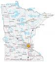
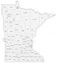
Minnesota County Map

About the map
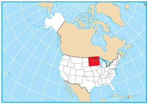
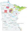
This Minnesota county map displays its 87 counties. Minnesota ranks 14th for the number of counties with just one less than Ohio. It borders North Dakota, South Dakota, Iowa, Wisconsin, and Lake Superior in the north of the United States.
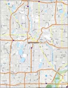
By far, the county with the highest population in Minnesota is Hennepin County, holding the largest city in Minneapolis. In fact, its population of over 1.25 million people means it’s the 33rd most populated county in all of the United States. The next most populous is Ramsey County with the capital city of Saint Paul, Minnesota. But the county with the smallest population goes to Traverse County, with just over 3000 residents.
For size, Saint Louis County more than doubles the second-largest county with an area of about 6800 square miles. This is followed by Koochiching, Beltrami, and Itasca County. But the smallest county in Minnesota is Ramsey County in the east of the state. It occupies an area of just 169.7 square miles.

You are free to use our county map of Minnesota for educational and commercial uses. Attribution is required. How to attribute?
Minnesota county list
| FIPS Code | Name | Land (sq mi) | Water (sq mi) | Population (2024) |
|---|---|---|---|---|
| 27-001 | Aitkin County | 1821.8 | 173.5 | 16,335 |
| 27-003 | Anoka County | 422.0 | 24.1 | 376,840 |
| 27-005 | Becker County | 1315.1 | 130.1 | 35,444 |
| 27-007 | Beltrami County | 2504.7 | 550.7 | 46,762 |
| 27-009 | Benton County | 408.3 | 4.7 | 41,881 |
| 27-011 | Big Stone County | 499.2 | 28.9 | 5,067 |
| 27-013 | Blue Earth County | 747.8 | 17.8 | 70,700 |
| 27-015 | Brown County | 611.1 | 7.2 | 25,710 |
| 27-017 | Carlton County | 861.3 | 14.0 | 36,745 |
| 27-019 | Carver County | 354.2 | 21.9 | 112,628 |
| 27-021 | Cass County | 2021.5 | 392.5 | 31,442 |
| 27-023 | Chippewa County | 581.1 | 6.7 | 12,299 |
| 27-025 | Chisago County | 414.9 | 27.5 | 59,105 |
| 27-027 | Clay County | 1045.2 | 7.5 | 66,848 |
| 27-029 | Clearwater County | 998.7 | 31.1 | 8,630 |
| 27-031 | Cook County | 1452.4 | 1887.2 | 5,571 |
| 27-033 | Cottonwood County | 640.0 | 8.6 | 11,338 |
| 27-035 | Crow Wing County | 998.4 | 158.2 | 68,642 |
| 27-037 | Dakota County | 562.4 | 24.4 | 453,156 |
| 27-039 | Dodge County | 439.3 | 0.3 | 21,242 |
| 27-041 | Douglas County | 636.8 | 83.3 | 39,933 |
| 27-043 | Faribault County | 712.5 | 9.4 | 13,886 |
| 27-045 | Fillmore County | 861.3 | 0.8 | 21,502 |
| 27-047 | Freeborn County | 707.3 | 15.1 | 30,314 |
| 27-049 | Goodhue County | 756.9 | 23.5 | 47,982 |
| 27-051 | Grant County | 547.8 | 27.7 | 6,109 |
| 27-053 | Hennepin County | 553.8 | 52.7 | 1,273,334 |
| 27-055 | Houston County | 552.0 | 16.8 | 18,352 |
| 27-057 | Hubbard County | 926.0 | 73.5 | 22,050 |
| 27-059 | Isanti County | 435.7 | 15.9 | 43,687 |
| 27-061 | Itasca County | 2667.3 | 260.6 | 45,442 |
| 27-063 | Jackson County | 703.0 | 16.3 | 9,861 |
| 27-065 | Kanabec County | 521.6 | 12.1 | 16,608 |
| 27-067 | Kandiyohi County | 797.4 | 65.0 | 44,674 |
| 27-069 | Kittson County | 1098.8 | 4.8 | 3,992 |
| 27-071 | Koochiching County | 3104.2 | 49.8 | 11,594 |
| 27-073 | Lac qui Parle County | 765.0 | 13.0 | 6,636 |
| 27-075 | Lake County | 2109.3 | 881.3 | 10,698 |
| 27-077 | Lake of the Woods County | 1297.9 | 481.7 | 3,797 |
| 27-079 | Le Sueur County | 448.7 | 25.1 | 29,458 |
| 27-081 | Lincoln County | 536.8 | 11.7 | 5,564 |
| 27-083 | Lyon County | 714.4 | 7.3 | 25,577 |
| 27-085 | McLeod County | 491.5 | 14.0 | 36,780 |
| 27-087 | Mahnomen County | 557.9 | 25.0 | 5,296 |
| 27-089 | Marshall County | 1775.1 | 37.8 | 8,771 |
| 27-091 | Martin County | 712.3 | 17.2 | 19,561 |
| 27-093 | Meeker County | 608.1 | 36.7 | 23,491 |
| 27-095 | Mille Lacs County | 572.4 | 109.2 | 27,577 |
| 27-097 | Morrison County | 1125.1 | 28.3 | 34,520 |
| 27-099 | Mower County | 711.3 | 0.2 | 40,900 |
| 27-101 | Murray County | 704.7 | 14.8 | 8,044 |
| 27-103 | Nicollet County | 448.6 | 18.3 | 34,493 |
| 27-105 | Nobles County | 715.1 | 7.5 | 21,969 |
| 27-107 | Norman County | 872.8 | 3.9 | 6,284 |
| 27-109 | Olmsted County | 653.5 | 1.4 | 166,424 |
| 27-111 | Otter Tail County | 1971.8 | 252.7 | 60,884 |
| 27-113 | Pennington County | 616.6 | 1.7 | 13,652 |
| 27-115 | Pine County | 1411.3 | 23.3 | 30,319 |
| 27-117 | Pipestone County | 465.1 | 0.9 | 9,100 |
| 27-119 | Polk County | 1971.1 | 26.7 | 30,413 |
| 27-121 | Pope County | 669.6 | 47.6 | 11,495 |
| 27-123 | Ramsey County | 152.2 | 17.9 | 542,015 |
| 27-125 | Red Lake County | 432.4 | 0.1 | 3,882 |
| 27-127 | Redwood County | 878.6 | 3.2 | 15,254 |
| 27-129 | Renville County | 982.9 | 4.2 | 14,453 |
| 27-131 | Rice County | 495.8 | 20.1 | 69,025 |
| 27-133 | Rock County | 482.5 | 0.3 | 9,525 |
| 27-135 | Roseau County | 1671.6 | 6.5 | 15,265 |
| 27-137 | St. Louis County | 6247.7 | 611.7 | 200,794 |
| 27-139 | Scott County | 356.2 | 12.1 | 157,206 |
| 27-141 | Sherburne County | 432.9 | 18.1 | 103,059 |
| 27-143 | Sibley County | 588.8 | 11.7 | 15,194 |
| 27-145 | Stearns County | 1342.8 | 47.2 | 163,997 |
| 27-147 | Steele County | 429.6 | 2.7 | 37,434 |
| 27-149 | Stevens County | 563.6 | 11.7 | 9,819 |
| 27-151 | Swift County | 742.0 | 10.1 | 9,666 |
| 27-153 | Todd County | 945.0 | 34.5 | 25,955 |
| 27-155 | Traverse County | 573.9 | 12.0 | 3,134 |
| 27-157 | Wabasha County | 523.0 | 26.6 | 21,574 |
| 27-159 | Wadena County | 536.3 | 7.0 | 14,437 |
| 27-161 | Waseca County | 423.4 | 9.6 | 18,684 |
| 27-163 | Washington County | 384.4 | 38.4 | 283,960 |
| 27-165 | Watonwan County | 435.0 | 4.8 | 11,204 |
| 27-167 | Wilkin County | 751.0 | 0.2 | 6,268 |
| 27-169 | Winona County | 626.1 | 15.5 | 49,973 |
| 27-171 | Wright County | 661.1 | 53.1 | 154,593 |
| 27-173 | Yellow Medicine County | 759.1 | 4.1 | 9,373 |