Public Land Survey System (PLSS) vs Dominion Land Survey (DLS)
The Dominion Land Survey (DLS) and the Public Land Survey System (PLSS) are two survey systems in North America. Both divide the land to help distribute land and assign land titles. Here are the differences between both survey systems.
Public Land Survey System (PLSS)
Dating back to 1785, the PLSS aimed to regulate the settlement and division of land in the United States. It was first established beginning with the Land Ordinance of 1785 under Thomas Jefferson.
Here are the key points of how the Public Land Survey System works:
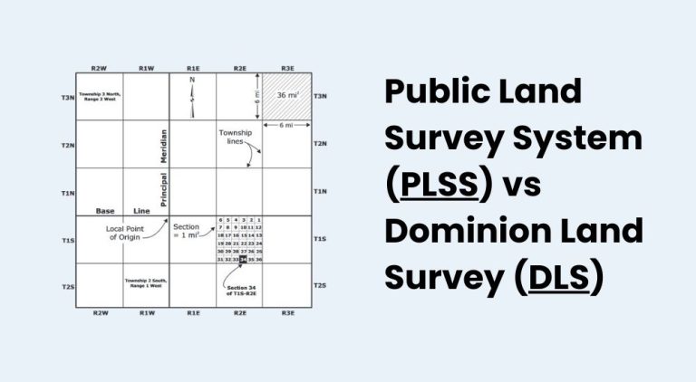
- PLSS arranges land into a grid of townships and sections.
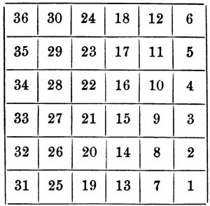
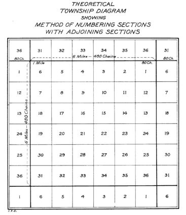
- A township under the PLSS divides land into 36 sections.
- Each section is approximately 1 square mile.
- Sections are further divided into ¼ sections.
- It uses a principal meridian and baseline for orientation.
- While ranges run north-south, townships run east-west.
The United States widely adopted the PLSS system except the original 13 colonies. This is true especially west of the Mississippi River, including the Midwest, West, and parts of the South.
Dominion Land Survey (DLS)
Similar to the PLSS, the Dominion Land Survey (DLS) laid the groundwork for dividing the land. But the main difference is that the DLS is specific to the Prairies and much later than the PLSS.
Here are important notes about the DLS survey system:
- Implemented in Canada, starting in 1871.
- Designed to facilitate the orderly settlement of the Canadian West.
- Provinces included Manitoba, Saskatchewan, Alberta, and parts of British Columbia.
- Organizes land into a grid of townships and sections.
- A township is divided into 36 sections, each approximately 1 square mile (640 acres).
- Uses a baseline and meridian system for reference.
- Ranges run north-south and townships run east-west from these lines.
The Dominion Land Survey (DLS) provided a systematic way to divide land in Canada. It became a cornerstone of Canadian history for how the West was settled. This when early parcel mapping began.
Public Land Survey System (PLSS) vs Dominion Land Survey (DLS)
Both survey systems share similarities in their purpose and design. But there are key differences in their implementation and historical context.
- Geographical Extent: DLS is specific to Canada, particularly the prairie provinces. Whereas the PLSS covers much of the United States.
- Historical Timeline: The DLS was established later (1871) than the PLSS (1785). This reflects the different timelines of settlement and expansion in Canada and the United States.
- Implementation: Both systems use townships and sections as fundamental units. But there are differences in the specific rules governing the subdivision and sale of land.
Despite being similar in how it lays townships out, they still have their minor differences.
Survey Systems in the United States and Canada
Both systems facilitate the distribution of land to settlers. The Land Ordinance of 1785 promoted agricultural development and established clear land titles. However, their differences are in the geography and history of Canada and the United States.
Do you have any questions about these survey systems that shape our land? We’d love to hear from you. Please write a comment below and we’d be happy to respond.


How are lots numbered, is there an order to the placement of the numbers?
Good question. I’ve always thought they were sequential by block and lot. Typically, they start at Lot 1 and increases numerically