The State Plane Coordinate System (SPCS)

A Brief History of the State Plane Coordinate System in America
In the early 1930s, the United States started building the State Plane Coordinate System (SPCS) to pinpoint any location with a high level of accuracy (less than 1:10,000).
It was primarily designed to be a system to permanently record original land survey monuments.
Because SPCS needs such a high level of accuracy, it divides the United States into 124 zones, each with a projection of its own.
Overall, the State Plane Coordinate System minimizes distortion (compared to the UTM system) because of the smaller zone sizes.
State Plane Coordinate System Zone Map Projections
Depending on the size of the area, a state can have one or many zones each using its own map projection. For example, Hawaii has 5 zones and Maryland has only one SPCS zone.
Each State Plane Coordinate System zone uses a map projection based on its geographic orientation.
Below, we’ll go through each projection and the developable surface it uses.
Transverse Mercator Projection
If the zone has a north-south orientation, it generally uses the Transverse Mercator projection. State Plane Coordinate System zones use the secant case of the Transverse Mercator projection.
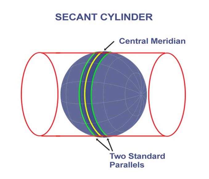
As shown above, it cuts through the spheroid/ellipsoid along two small circles at a specific distance from a central Meridian.
Lambert Conformal Conic Projection
While cartographers use the Lambert Conformal Conic projection for large continents, it’s the most common map projection among the SPCS zones.
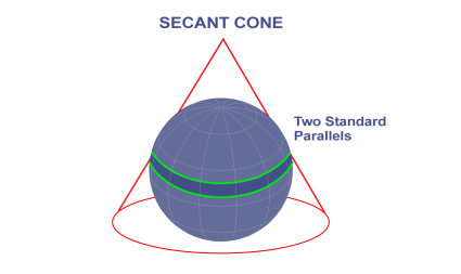
When the zone has an east-west shape, it most likely uses the Lambert Conformal Conic projection.
Hotine Oblique Mercator Projection
Finally, the Hotine Oblique Mercator projection is similar to the Transverse Mercator. However, the key difference is how this projection lies at an angle diagonally.
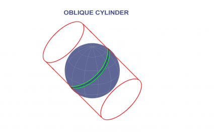
This diagonal orientation allows the Hotine Oblique Mercator projection to effectively capture the unique characteristics of specific regions.
State Plane Coordinate System FIPS Code
Anyone can identify their State Plane Coordinate System zone with a unique FIPS code. For example, Alaska has 10 State Plane Coordinate System zones with a unique FIPS code and map projection.
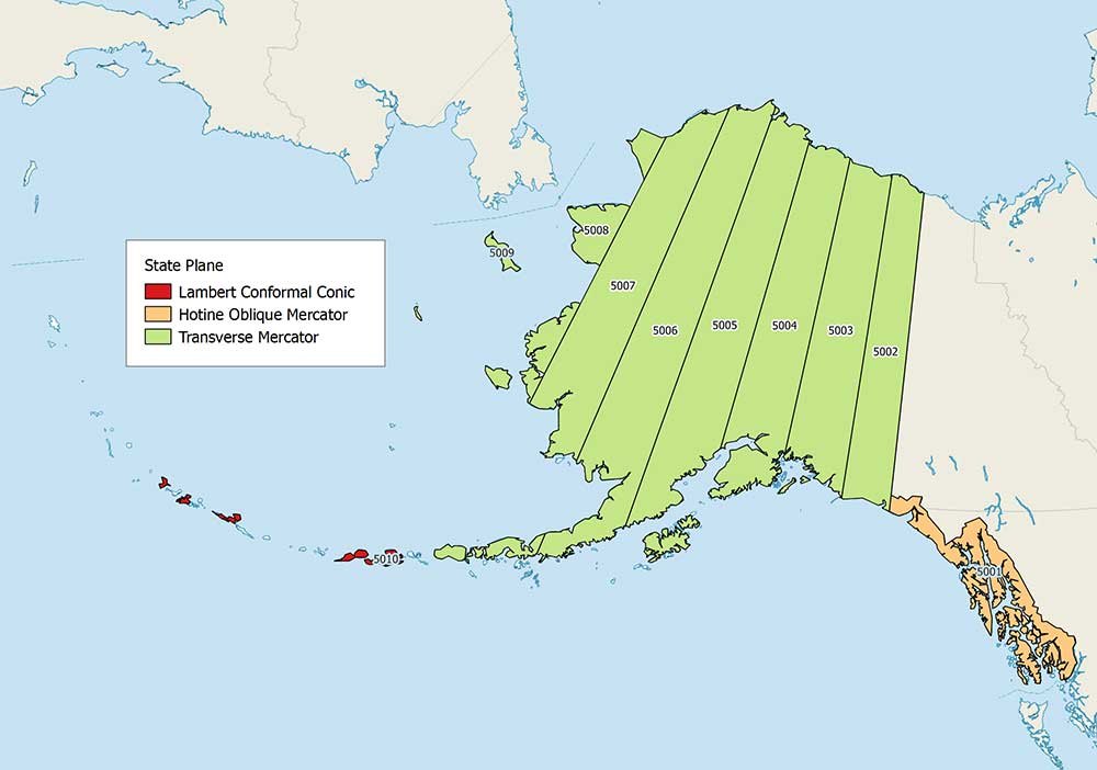
- For FIPS Zone 5001 (Alaska), it uses the Hotine Oblique Mercator
- From FIPS 5002 to 5009 (Alaska), it projects these zones with a Transverse Mercator
- Finally, the Alaska FIPS 5010 zone uses the Lambert Conformal Conic
The map below shows a thematic map of all the projections that the State Plane Coordinate System uses.
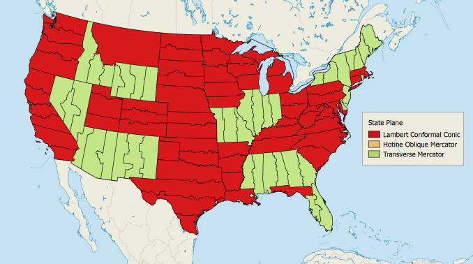
It separates which zone uses Lambert Conformal Conic, Transverse Mercator, and Hotine Oblique Mercator projections.
SPCS 27 and SPCS 83
Over the years, surveyors have significantly improved our understanding of the size and shape of the Earth using geodesy. As a result, the State Plane Coordinate System references both the NAD83 and NAD27 datums.
- State Plane Coordinate Systems (SPCS 27) references NAD27 as a standard unit of measure in US survey feet
- State Plane Coordinate Systems (SPCS 83) is based on the NAD83 datum and is commonly measured in meters
Since the advent of NAD83, the State Plane Coordinate System has undergone a series of changes. For example, this includes zone modifications and origin changes.
State Plane Coordinate System Advantages
Government agencies use the State Plane Coordinate System because each zone has a defined boundary.
Counties can manage their data to a common coordinate system with those county and state lines.
Because of the limited distortion due to each zone having its own projection, the SPCS is most suitable for engineering, public works, and surveying applications.
To explore the SPCS in more detail, NOAA’s State Plane Coordinate System Manual gives an old-school flavor to its origin.


Best site out of many that I visited for diagrams and descriptions of the two main projections used, and the justification for each. Using color coding for the two projections used is great, as are the diagrams for those two projections. You should have labeled the zones south and north and described that a bit, I think. Actually, I am still confused about the use of numbers for zones (saw that on one site) and the use of north-south or east-west. Very well written page, however, with awesome diagrams.
The article is well written and supported by clear graphics that illustrate the proper secant case of every projection method. Well done. My only criticism is with the “Secant Cylinder” figure; the standard small circles are mislabeled as parallels, which is a term reserved for describing parallel lines of latitude. Fix that typo, and I’ll be able to share this resource with my students.
Thanks Scott. I’ve updated that figure. Please feel free to share with your students if you wish.