DEM, DSM & DTM: Elevation Models in GIS
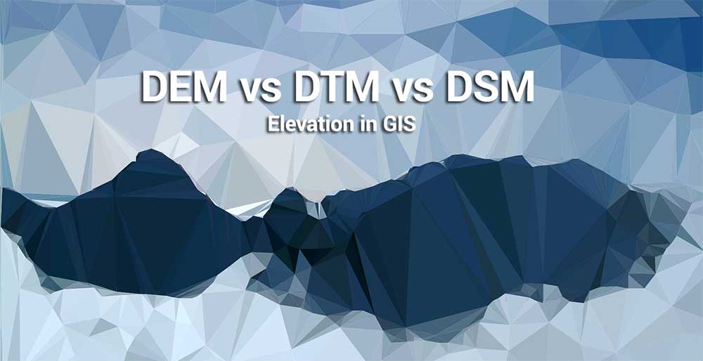
DEM vs DSM vs DTM vs TIN
When it comes to elevation, we have three different ways to model elevation. They can include any of the following:
- DEM – Digital Elevation Models
- DSM – Digital Surface Models
- DTM – Digital Terrain Models and even
- TIN – Triangular Irregular Networks
Well, today we are going to set the record straight with your elevation frustration. Let’s explore the differences between these three types of GIS elevation models.
What is a Digital Surface Model (DSM)?
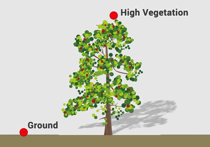
In a LiDAR system, pulses of light travel to the ground. When the pulse of light bounces off its target and returns to the sensor, it gives the range (a variable distance) to the Earth. Hence, how this system earned its name Light Detection and Ranging.
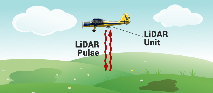
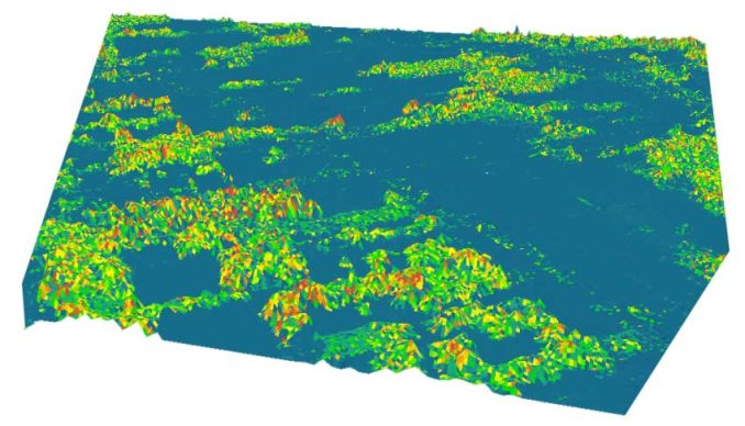
In the end, LiDAR delivers a massive point cloud with elevation values. But height can come from the top of buildings, tree canopy, powerlines, and other features. A DSM captures the natural and built features on the Earth’s surface.
A DSM is useful in 3D modeling for telecommunications, urban planning, and aviation. Because objects extrude from the Earth, this is particularly useful in these examples:
RUNWAY APPROACH ZONE ENCROACHMENT: In aviation, DSMs can determine runway obstructions in the approach zone.
VEGETATION MANAGEMENT: Along a transmission line, DSMs can see where and how much vegetation is encroaching.
VIEW OBSTRUCTION: Urban planners use DSM to check how a proposed building would affect the viewshed of residents and businesses.
What is a Digital Elevation Model (DEM)?
A digital elevation model is a bare-earth raster grid referenced to a vertical datum. When you filter out non-ground points such as bridges and roads, you get a smooth digital elevation model. The built (power lines, buildings, and towers) and natural (trees and other types of vegetation) aren’t included in a DEM.
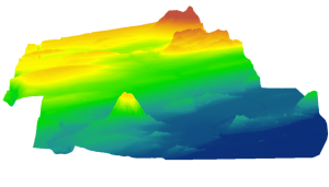
When you void vegetation and man-made features from elevation data, you generate a DEM. A bare-earth elevation model is particularly useful in hydrology, soils, and land use planning
HYDROLOGIC MODELING: Hydrologists use DEMs to delineate watersheds, and calculate flow accumulation and flow direction.
TERRAIN STABILITY: Areas prone to avalanches are high slope areas with sparse vegetation. For example, aspect maps are useful in studying slope direction to prevent avalanches.
SOIL MAPPING: DEMs assist in mapping soils which is a function of elevation (as well as geology, time, and climate).
What is a Digital Terrain Model (DTM)?
When you refer to the USGS LiDAR Base Specification (on page 28), a digital terrain model (DTM) actually has two definitions depending on where you live.
- In some countries, a DTM is actually synonymous with a DEM. This means that a DTM is simply an elevation surface representing the bare earth referenced to a common vertical datum.
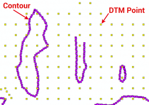
- In the United States and other countries, a DTM has a slightly different meaning. A DTM is a vector data set composed of regularly spaced points and natural features such as ridges and breaklines. A DTM augments a DEM by including linear features of the bare-earth terrain.
DTMs are typically created through photogrammetry as in the example above. For example, contour lines are in purple. The DTM points are regularly spaced and characterize the shape of the bare-earth terrain.
In the image above, you can see how the DTM is not continuous and that it’s not a surface model. From these regularly-spaced contour lines, you can interpolate a DTM into a DEM. A DTM represents distinctive terrain features much better because of its 3D breaklines and regularly spaced 3D mass points.
READ MORE: Free Global DEM Data Sources
How to capture Digital Elevation Models?
Some of the remote sensing methods for obtaining DEM surfaces are:
SATELLITE INTERFEROMETRY: Synthetic aperture radar such as Shuttle Radar Topography Mission uses two radar images from antennas captured at the same time to create a DEM.
PHOTOGRAMMETRY: In aerial photography, photogrammetry uses photographs from at least two different vantage points. Similar to how your vision works, it’s able to obtain depth and perspective because of the separate vantage points.
LiDAR: Using light, LiDAR measures reflected light that bounces off the ground and back to the sensor to obtain the elevation of the Earth’s surface.
Shaded relief shows the shape and elevation of the land by simulating shadows on the terrain. It makes it easier to visualize hills, valleys, and mountains with a three-dimensional and realistic look. Here are examples of shaded relief maps of each state in the United States.
DEM, DSM & DTM Differences
In the vast world of geospatial data and mapping, understanding the nuances between DEMs, DSMs, and DTMs is an essential compass for accurate terrain representation and analysis.
As we navigate through the intricate landscapes of elevation data, we uncover the distinctive characteristics that define each dataset.
First, the DEM has bare-bones elevation values. Secondly, DSM’s representation of terrain and structures and the DTM’s terrain-focused precision. A Triangular Irregular Network (TIN) is a way to represent a 3D surface. Each plays a unique role in shaping our spatial insights.
Got any questions? Please let us know if the comment section below and we’ll be happy to answer.


Very useful information
But I have put my Vertical Lines things are not working out properly
Nicely done. Simple and accurate – from a CP.
Many thanks for your clarifications.
Very educational, but can you give a more detailed explanation for a digital terrain model?
Can we use DSM for mapping informal settlements?
How does aerotriangulation affect generation of DEMs and DTMs
Where do TIN’s fit in with this?
Triangular Irregular Networks are vector-based lines with three-dimensional coordinates. Using Delanuay triangulation, TINs are good when points are irregular distrubuted geographically… The downside with TINs is that you often can’t run tools for slope, aspect, flow networks, etc
(trees and other types of vegetation) aren’t extruding in a DEM.
Shouldn’t it say:
(trees and other types of vegetation) aren’t INCLUDED in a DEM.
That’s another way to put it. But it’s also true that vegetation isn’t extruding and is simply elevation of the bare ground
great explanation for a non-GIS person like myself