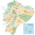
Map of Ecuador – Cities and Roads
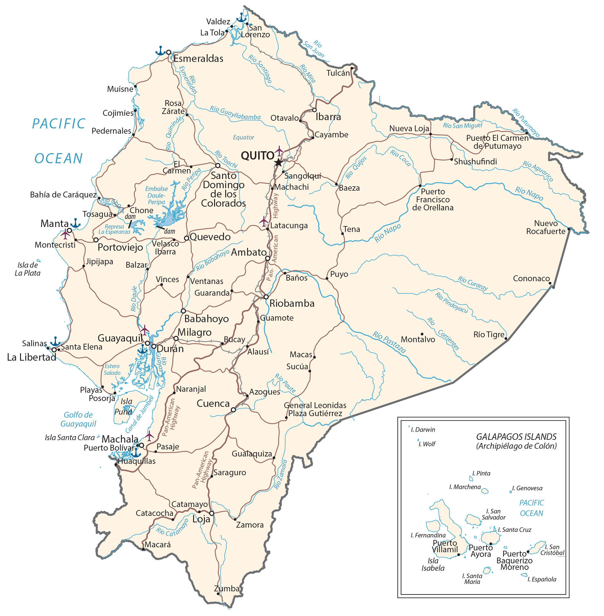
Ecuador is a country that’s named for being located on the equator! This map collection features a reference map, satellite imagery, and a physical map with cities, highways, islands, lakes, and rivers.
Ecuador map collection
You are free to use our Ecuador map for educational and commercial uses. Attribution is required. How to attribute?
About the map
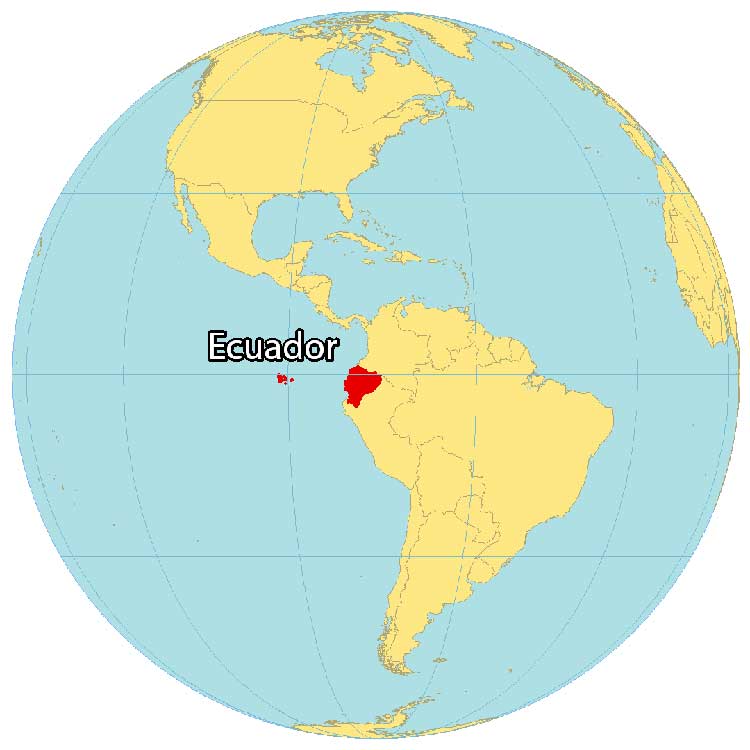
Ecuador is in western South America, along the Pacific Ocean with a coastline of 2,237 kilometers (1,380 mi). It straddles the equator which is the reason why its name is Ecuador. Ecuador borders just 2 other South American countries including Peru to the south and Colombia to the north.
About 950 kilometers (585 mi) off the west coast, Ecuador contains the Galapagos Islands. This group of volcanic islands is the location where Charles Darwin theorized the Theory of Evolution. Quito is the capital of Ecuador but Guayaquil is its largest city.
The geography of Ecuador is varied and includes a wide range of landscapes, from the Amazon Rainforest to the Andes mountains to the Pacific coast. The country is home to a variety of plant and animal species, as well as a number of indigenous peoples.
SATELLITE IMAGERY
Ecuador Satellite Map
Ecuador occupies a total area of 283,561 square kilometers (109,484 sq mi), which includes the Galápagos Islands in the Pacific Ocean. It’s a mosaic of various landscapes such as the Amazon Jungle, the Andean Highlands, and its coastal lowlands.
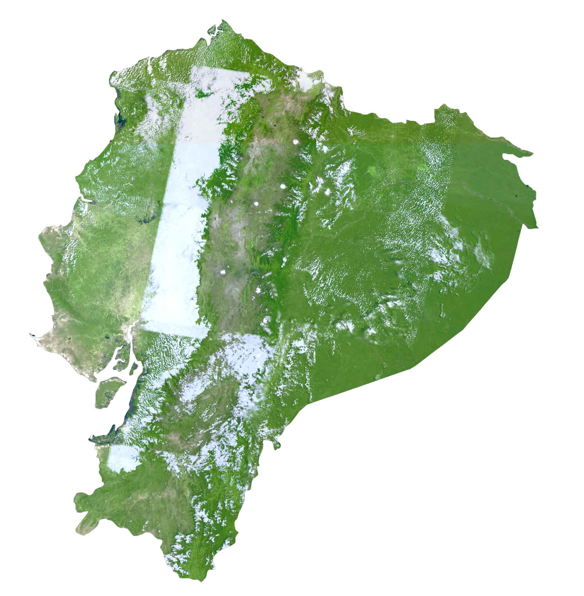
According to the FAO, forests cover almost 50% of Ecuador such as in the Amazon Basin. The climate in Ecuador is tropical along the coasts because the country is situated right on the equator. But as you move into the mountainous regions, temperatures become much cooler.
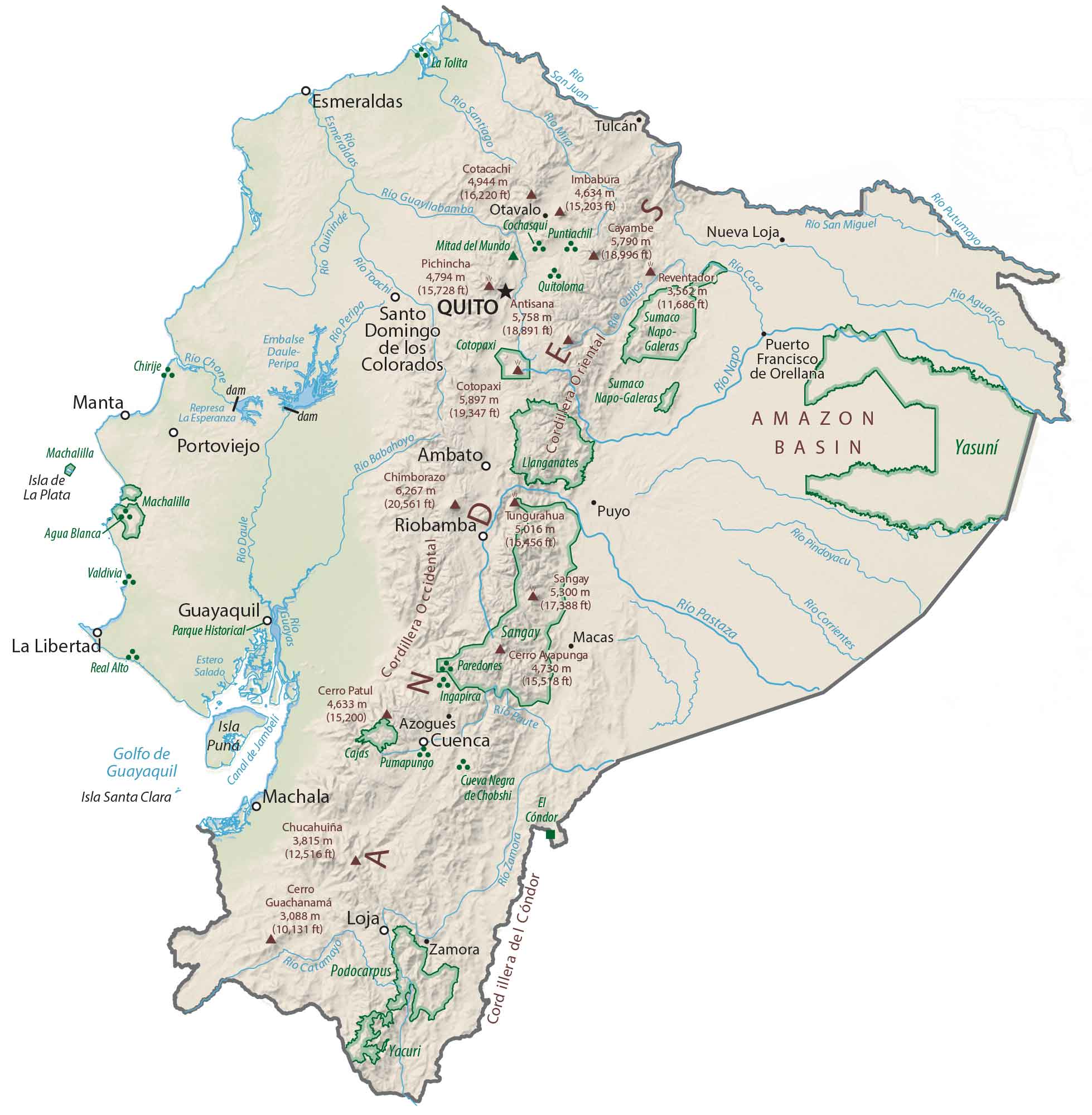
PHYSICAL MAP
Ecuador Physical Map
The spines of the Andes Mountains split the country in a west and east divide. First, the Amazon Basin is situated to the east offering lush rainforests and exceptional biodiversity. Next, the broad coastal plains to the west are where most agriculture takes place all the way until it rises to the foothills of the Andes.
Because the Earth bulges at the equator, Ecuador’s Mount Chimborazo is the farthest point above Earth’s surface. But because we measure mountain peaks above sea level, Mount Everest in Nepal is still considered taller than Mount Chimborazo. Nevertheless, at 6,263.47 m (20,549.4 ft), this is the tallest peak in Ecuador.
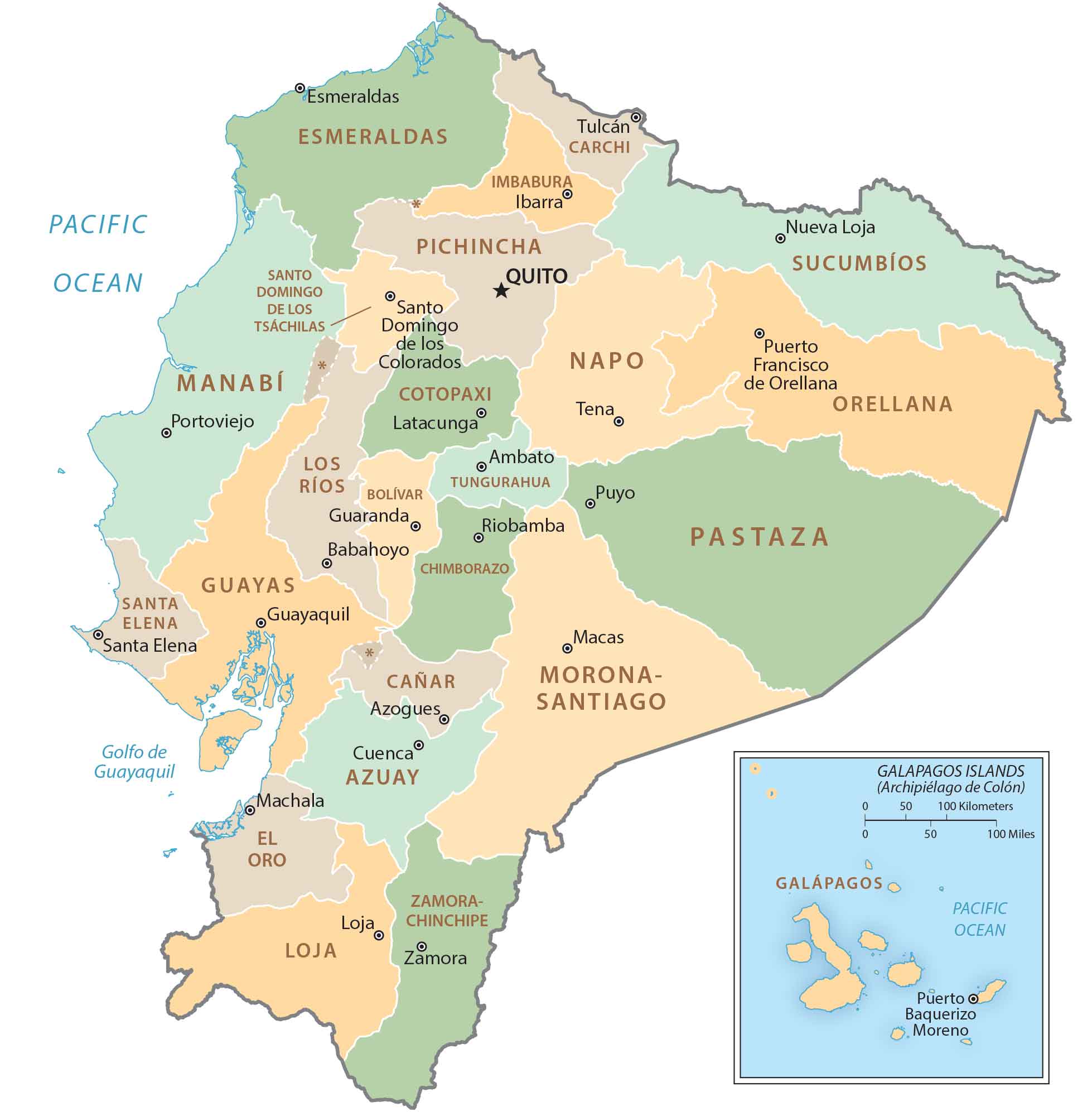
POLITICAL MAP
Ecuador Provincial Map
There are 24 provinces in Ecuador. First, the La Sierra region contains 10 provinces including Azuay, Bolivar, Cañar, Carchi, Chimborazo, Cotopaxi, Imbabura, Loja, Pichincha, and Tungurahua. Secondly, the La Costa region consists of 7 provinces – El Oro, Esmeraldas, Guayas, Los Ríos, Manabí, Santa Elena, and Santo Domingo de los Tsáchilas.
Finally, the El Oriente region holds 6 provinces including Morona-Santiago, Napo, Orellana, Pastaza, Sucumbíos, and Zamora-Chinchipe. Lastly, the Galapagos Islands is its own province without being part of another region.
Capital City
Quito
Major cities and towns
Ambato
Cuenca
Durán
Esmeraldas
Guayaquil
Loja
Machala
Manta
Milagro
Riobamba
Quevedo
Santo Domingo
Cities, towns and villages
Alausí
Azogues
Babahoyo
Bahía de Caráquez
Balzar
Baeza
Catacocha
Cayambe
Chone
Cojimíes
Cononaco
El Carmen
General Leonidas Plaza Gutiérrez
Guamote
Guaranda
Gualaquiza
Jipijapa
La Libertad
La Tola
Latacunga
Macará
Macas
Machachi
Montalvo
Montecristi
Muisne
Naranjal
Nueva Loja
Nuevo Rocafuerte
Otavalo
Pedernales
Playas
Posorja
Puerto Bolívar
Puerto El Carmen de Putumayo
Puerto Francisco de Orellana
Puyo
Rosa Zárate
Salinas
San Lorenzo
Sangolquí
Santa Elena
Saraguro
Shushufindi
Sucúa
Tena
Tosagua
Tulcán
Valdez
Velasco Ibarra
Ventanas
Vinces
Zamora
Zumba
Río Tigre
Lakes, rivers and creeks
Aguarico River
Babahoyo River
Canal de Jambeli
Catamayo River
Coca River
Corrientes River
Curaray River
Daule River
Embalse Daule-Peripa
Estero Salado
Golfo de Guayaquil
Guayllabamba River
Mira River
Napo River
Pacific Ocean
Paute River
Peripa River
Pindoyacu River
Putumayo River
Quijos River
Quininde River
Represa La Esperanza
San Juan River
San Miguel River
Santiago River
Toachi River
Islands
Darwin Island
Española Island
Fernandina Island
Genovesa Island
Isla Isabela
Isla de la Plata
Isla Puna
Isla Santa Clara
Marchena Island
Pinta Island
Puerto Ayora
Puerto Baquerizo Moreno
Puerto Villamil
San Cristóbal Island
San Salvador Island
Santa Cruz Island
Santa María Island
Wolf Island
Other
Pan-American Highway