The Geospatial Industry: Past, Present and Future
An Introduction to the Geospatial Industry
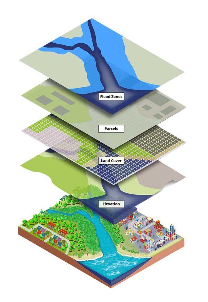
The geospatial industry is all about maps and location. It helps us know where things are and where to go.
Looking for a café or park? It’s the applications built on the shoulders of the geospatial industry that guides us there.
But what is the extent of the geospatial industry? And who is part of this growing industry? Today, let’s explore its impacts on today’s society.
The Boom for Geospatial Information
Maps have come a long way from just paper. Now, they’re interactive with real-time data. For example, real-time traffic maps show us how to avoid any traffic jams. But this boom in geospatial information didn’t just happen overnight.
Under the leadership of Roger Tomlinson in the 1960s, the Canada Land Inventory was the first operational GIS. From there, the 1970s saw the establishment of the USGS’s Digital Line Graph (DLG) program.
Next, the 1980s marked the beginning of the commercialization of GIS. Software from companies like Esri and Intergraph became mainstream. Now, open source GIS software like QGIS and GRASS GIS are paving the way.
Looking for more? Check out the Penn State Geospatial Revolution for more details.
Top Geospatial Companies
The table below shows a mix of commercial companies. From software to satellite and GPS companies, here’s who’s shaping the geospatial industry today.
| Company Name | Specialization |
| Esri | ArcGIS products for mapping and spatial analytics |
| Trimble | GPS, laser, optical, and inertial technologies |
| Hexagon AB | Geospatial and industrial solutions |
| DigitalGlobe | High-resolution Earth imagery |
| HERE Technologies | Mapping and location data services |
| Garmin | GPS technology for navigation |
| Leica Geosystems | Geospatial measuring instruments |
| TomTom | Location technology and consumer electronics |
| Mapbox | Custom online maps for websites and applications |
| Planet Labs | Satellite imaging for Earth observation |
| Airbus Defence and Space | Satellite imagery and geospatial data |
| Maxar Technologies | Space technology and geospatial intelligence |
| Intergraph | Geospatially powered software |
Top Open Source GIS Projects
Make no mistake about it. But open source GIS is trending upwards. This table showcases various types of open source GIS software. From desktop programs to web mapping services and databases, here are the top open source GIS options.
| Software Name | Short Description |
| QGIS | Desktop GIS for data analysis and editing. |
| OpenStreetMap (OSM) | Collaborative project for a free editable world map. |
| GRASS GIS | GIS for data management, analysis, and visualization. |
| GDAL/OGR | Library for geospatial data format conversion. |
| PostGIS | Spatial database extension for PostgreSQL. |
| GeoServer | Server for sharing geospatial data using open standards. |
| MapServer | A platform for web-based spatial data publication. |
| Leaflet | JavaScript library for interactive maps. |
| GeoNetwork | Catalog for sharing geospatial data and maps. |
Who Is Part of the Geospatial Industry?
The geospatial industry is extremely diverse. First, we have cartographers. Making maps is an understatement. It sounds simple, but there’s a lot of detail involved. You not only have to know map design, but you also often have to know database management.
Then, there are GIS analysts. They use the maps to solve problems. There’s not too much of a difference between GIS technicians and GIS specialists. Both roles often overlap in their duties. Often, coding is one of those roles.
There are also lots of roles that aren’t necessarily GIS. But they often use it in their line of work. Here are a couple of those examples.
- Remote sensing specialists work with satellite images.
- Urban planners use GIS data to improve cities.
- Environmental scientists keep an eye on nature, often collecting GPS data in the field
- Surveyors measure land, making sure maps are accurate.
- Software developers create apps using maps.
- Data scientists find patterns and turn data into stories.
- Emergency managers use maps to prepare for disasters.
- Transportation officials plan better routes.
- Agriculturists use satellite imagery to grow food more efficiently.
So, everyone in the geospatial industry brings something different to the table. But the goal is that the geospatial industry helps us understand our world using location.
What Is the Future of the Geospatial Industry?
Today, GIS is at the forefront of technological advancement. Here are some of the advancements that we are already seeing and will see more in the future.
- AI Meets Maps: AI will make maps smarter. AI maps will help predict better and faster.
- Drones and Satellites: They will bring us clearer pictures from the sky. Data will become more available to see the world in more detail.
- More 3D Maps: Cities and landscapes in 3D are on the rise. We are in the state of building digital twins in our environments.
- Everyone Uses GIS: From farmers to city planners, everyone will use GIS. It helps make better decisions.
- Mobile Mapping Grows: Mapping on smartphones gets even easier. Everyone can be a mapmaker while on the move.
- Big Data Boom: There’s more data than ever. Much more than our computers can compute. GIS helps make sense of it. It’s like finding a needle in a haystack.
- Sustainability Efforts: GIS will help us take care of the Earth. It can track changes and protect nature in real time.
- Geospatial Analytics: Prediction is key. It finds patterns and answers in the data. Very useful for solving problems.
Conclusion: The Geospatial Industry
The geospatial industry is booming. It uses maps and data to make sense of the world. This is key for things like planning cities and helping after disasters. In the end, the geospatial industry is about connecting us to the world.
Looking ahead, the geospatial industry is set to evolve. It will adapt to new technology like AI and augmented reality. This will help us make smarter choices for our planet. And that’s a big win.


