What Can You Do with a GIS Degree?

What Can You Do with a GIS Degree?
Is a GIS degree worth it? What types of jobs can I get with a GIS degree? Are there alternatives for GIS certification, online programs, and diplomas? YES, there are :)
If you’re asking these types of questions about a GIS degree or alternatives, then you’ve come to the right place for answers.
Because not only will you learn about career options for GIS graduates, but you’ll also find out about earning potential.
Let’s do this.
Entry and Senior GIS Positions
But there are tons more potential career options with a GIS degree. For example, this table lists typical job titles for GIS degree graduates. As you can see, positions can range anything from entry-level to senior-level.
Entry Positions
- CAD Drafter
- GIS Technician
- Survey CAD Technician
- Cartographic Technician
- Land Survey Technician
Low to Mid-Range Jobs
- GIS Analyst
- Geodesist
- Geographer
- LiDAR Analyst
- Cartographer
- GEOINT
Mid to High-Level Jobs
- Remote Sensing Analyst
- Geographic Information Systems Specialist
- GIS Administrator
- Senior CAD Designer
- GIS Developer
Senior Positions
- Senior GIS Analyst
- GIS Coordinator
- Senior CAD Engineer
- GIS Software Engineer
- Survey Manager
- GIS Project Manager
- Senior Geomatics Software Engineer
List of 13 Careers for GIS Degree Graduates
It’s said that you don’t truly know your data until you can see it geographically. Because we can connect information to locations, Geographic Information Systems (GIS) is changing the way we do decision-making.
The main functions of a GIS are to create geographic data, analyze it and display it on a map. And this fits the three main career options you can land as a career:
- GIS Analyst: This is one of the most common roles for GIS degree holders. GIS analysts gather, analyze, and interpret geographical data to create maps, charts, and visualizations that help organizations make informed decisions. They work in industries such as urban planning, environmental management, and logistics.
- GIS Technician: GIS technicians work under the guidance of analysts and professionals to collect and manage geographical data, maintain GIS databases, and produce maps and reports. Although they’re known to do a lot of the “grunt work”, they also dabble into analysis and mapping.
- Cartographer: Cartographers design and produce maps that communicate geographic information effectively. They might work on creating topographic maps, thematic maps, and interactive online maps.
- Spatial Data Scientist: Spatial data scientists combine GIS skills with advanced data analysis techniques to extract insights from geographical data. They work on complex spatial problems, such as predicting urban growth patterns, analyzing disease spread, or optimizing transportation routes.
- Remote Sensing Specialist: Remote sensing specialists use satellite and aerial imagery to monitor and analyze changes in the Earth’s surface. They are often employed in environmental monitoring, agriculture, forestry, and disaster response.
- Urban/Regional Planner: Urban and regional planners use GIS to analyze spatial data and help plan and develop communities. They can analyze factors like population density, land use, transportation networks, and environmental considerations to guide development decisions.
- Environmental Scientist: Environmental scientists use GIS to analyze and visualize data related to natural resources, ecosystems, and environmental changes. They can work on projects related to land conservation, pollution monitoring, and disaster response.
- Natural Resource Manager: Natural resource managers use GIS to plan and manage land use for conservation purposes. They work to balance human activities with the preservation of natural resources.
- Transportation Planner: Transportation planners use GIS to analyze traffic patterns, plan efficient transportation networks, and optimize routes for vehicles and public transit systems.
- Emergency Management Specialist: GIS is crucial in emergency management to assess risk, plan evacuation routes, and coordinate disaster response efforts.
- Geospatial Software Developer: If you have programming skills, you could develop GIS software, tools, and applications that help professionals work with spatial data more effectively.
- Academic/Researcher: With a GIS degree, you could pursue research or academic careers, studying topics related to geography, spatial analysis, or cartography.
- Geospatial Data Manager: Geospatial data managers oversee the collection, storage, and quality control of spatial data within organizations.
Typical GIS Employers: Which Fields Can You Work In?
A while back, I had a comment asking about which industries GIS integrates most with.
If there was one industry you could complement with a GIS degree, which one would it be?
Actually, there are too many to list. But based on job listings, here is a list of typical employers who hire GIS degree graduates:
As GIS is still a relatively new technology, there are thousands of GIS applications waiting to fuse into various industries.
READ MORE: Thinking Outside the Box for GIS Jobs
GIS Degree Salary: How Much Money Can You Make?
Like most careers, positions can range from entry-level to senior. At the lower end of the pay scale, technicians and draftsmen typically earn the least. For these types of positions, skills include databases, CAD, and mapping.
As you move into a higher pay scale, there are more specialized jobs. For example, remote sensing and LiDAR analysts are part of the mid-range pay scale. Also, we start to see GIS developers and programmers who create the GIS software that analysts and cartographers use.
At the top of the pay scale, senior GIS positions dominate the salary list. For example, GIS project managers execute and close projects. Also, senior software engineers have the experience and education necessary to design, develop, and maintain software.
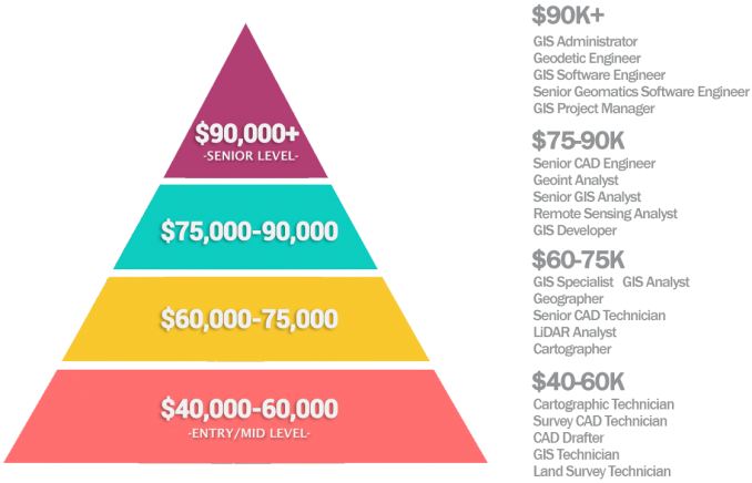
If you have a higher level of education and experience, you are more likely to be at the top of the pay scale and earn more.
READ MORE: GIS Salary Expectations: Climb the GIS Career Ladder
Career Outlook for GIS Degree Graduates
According to the US Bureau of Labor Statistics (BLS), geographers earn an average of $88,900 annually. Currently, the outlook is stable for geographers. On the other hand, cartographers and photogrammetrists earn $71,890 per year with a job outlook to grow 3% from 2021 to 2031. Overall, this is much faster than the average rate of growth.
According to Indeed, GIS developers and managers account for the highest percentage of job postings. In this line chart, GIS has been steady for job prospects.
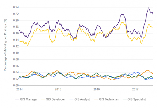
Even though GIS technicians, specialists, and analysts have the lowest number of available jobs, these job roles often overlap. If you added up their job postings, it would be similar to GIS managers and developers.
Even though all situations are different, Payscale gives a fairly decent quality of life ratings for GIS analysts:
- Personal satisfaction: C
- Benefit to society: B
- Flexibility: B
- Low stress: A
The Alternative: GIS Diploma / Certification
If you don’t want to go “all in” with a GIS degree, the alternatives are a GIS diploma or GIS certification. Alternatively, there are online GIS certificate programs.
These are fairly good options because you can complement other expertise such as in engineering, environment, or soil. Because GIS certification can help differentiate you from the crowd, it can also give you the extra credentials you need.
In GIS, the two main GIS certifications that employers look for are:
- Geographic Information Systems Professional (GISP) requires at least 4 years of full-time experience in GIS, contributions to the GIS community, and passing the GISCI Geospatial Core Technical Knowledge Exam.
- Esri Technical Certification (Desktop, Developer and Enterprise) is completely knowledge-focused and exam-based.
Both certification programs expect a level of proficiency in GIS and test your skill level. No matter what you choose (GIS degree, GIS diploma, or GIS certification), it depends on your current level of proficiency and what you want to get out of it.
READ MORE: GIS Certification: Is It Worth It?


I want to do a bachelor’s degree in geographical sciences at Makerere university but I don’t know what kind of career path I can take
I have done Bachelors in Electrical Technology. Can I get admission to Masters in GIS at VIU?
l like to be in this field
What projects can be applied using GIS?? A GIS graduate faces difficulty in defining his graduation project. Can you help??!!
Here are 1000 applications of GIS for project ideas – https://gisgeography.com/gis-applications-uses/
So I have a BS in Political Science and Government and was wondering if you think that the GIS would pair well with that? Currently, I am not even using my degree working as a civilian for the US Army.
Hi. I am about to graduate with bachelor’s degree in forestry. Can I pursue a postgraduate study in GIS? If yes, which university will be good for study? Better if it provides financial aids. I am from Nepal.
Hi Ailee. Unfortunately, I don’t know much about the different universities and colleges in Nepal.
I have done bachelor’s in Architecture. Can I get admission in Masters in GIS in VIU?
Hello,
I hold a Msc in geo-information science for environment and Sustainable development. What online GIS courses you can recommend me to do so that I become fluent in Both GIS and Remote sensing? What are the jobs list that are suitable with my qualification?
There are some good options for online training through Esri’s MOOCs – https://gisgeography.com/free-esri-training/
Specifically, “Earth Imagery at Work” targets imagery collected by satellites, LIDAR, and drones.
GISGeography also have a lot of “how to” articles on remote sensing. Take a look here – https://gisgeography.com/category/remote-sensing/
Was there anything specific to remote sensing such as image classification, photogrammetry, synthetic aperture radar, object-based image analysis, etc?
Hello,
I have completed my Bachelors Degree in IT. I have worked in a navigation company as a GIS Analyst for 3 years. I want to establish my career in GIS and I want to study in more depth about it. What should I choose to study a DEGREE/CERTIFICATION/COURSE ? or any other suggestions? Also what would help more to seek a job in a foreign country?
I am interested in studying GIS. I’m a geography teacher in South Africa. How can I do my GIS course while working? Would you recommend online courses for me? Even though I don’t have any qualification for GIS?
I think it would be suitable for you to take an online course in GIS. I also suggest to get involved as much as possible in your local GIS community. For example, the Geo-Information Society of South Africa (GISSA) would be a good option.
Do GIS skills ensure 95% job chances in environmental sciences sector? How reliable is GIS course to find a job in NGOs, governmental agencies and city offices especially in 2020? What about the mixture of GIS with remote sensing skills in reference to finding a suitable job?
I have done Bachelors of Arts in geography and then now post graduation in Geography(GIS) ..
I want to opt my career in GIS .. what should I do next? after my post graduation
Hi Meghali. For training, there are a range of certification options. https://gisgeography.com/gis-certification-is-it-worth-it/
If you’re looking to go straight into a GIS career, here are some tips that can help out. https://gisgeography.com/10-gis-career-tips-find-gis-job/
Please let me know if you have any questions
I have worked in GIS for 20 years, and have worked in many other areas with softwares other than ArcGIS, but recently was let go from a job that I had worked at for 7 years, where the bulk of my work was done with ArcGIS, MS Excel, some Geomedia, and custom apps—stuff by itself that isn’t going to advance my career.. I want to get back in the field but I recognize two problems when applying for jobs:
1) how long can I make work that I did years ago relevant to today, when most employers are wanting to see things done with nore current software?
2) How much can I rely on one job to explain my experience if it doesn’t cover certain things? i.e., I didn’t do application development or analysis in my most recent position. How do I cover that up?
I’m 29 and feel like I’m slowly burning out after years of working in some highly demanding human services positions. I’ve wondered for a while if something more concrete, realistic, and investigative would be a better fit for me – and simply less stressful. I’ve always loved maps, data, and computers (I’m not sure why GIS never popped up on my radar). I’ve got an MA in a completely unrelated field. My wife and I also just had a child.
Any input on getting into GIS as a second career/as someone with a family?
Hi Paul
Great question.
I know after having a first child it can take a lot of time out of life, especially if you are thinking about upgrading your career. That’s why it’s best to give it a try before you want to completely commit to the field.
QGIS is completely free, open-source software (https://qgis.org). You can start simple, such as using some of the open data sources available. https://gisgeography.com/best-free-gis-data-sources-raster-vector/
Create a couple of maps or webmaps, try editing some of the features and test out the analysis tools. These are the tasks that GIS analysts perform everyday. You’ll need a good overview of how to do all these before you apply for a job. If you need ideas what to do, probably a great place to start is your local GIS group.
I know that having a baby is a big commitment so I would suggest online courses in GIS. It looks great on your CV/resume. When you apply, employers are really looking for it. Once you become a student, Esri has a discounted version for ArcGIS. Esri ArcGIS is the industry standard for GIS software, so it would be nice to have this for experience.
Other than this, I’d suggest taking a looking at our article on 10 GIS career tips to help find a job. There are a lot of good ideas in here about the job market situation. There can be a lot of competition for some positions so that’s why some level of education or certification I think is necessary. https://gisgeography.com/gis-career-job/
Hope this helps. Let me know if there’s anything specific you’d like me to expand on.
And good luck!
I was looking into a ASS in coastal studies and GIS, I live in New Orleans, just wondering how hard it really is to get a job straight out of school ?
I’ve heard varying degree of difficulty after graduating in Louisiana and the surrounding area. Try connecting with URISA because GIS-Pro 2019 just took place in New Orleans.
Not too sure what that abbreviation stands for in coastal studies. Please respond and let me know. But bet they wish they could’ve thought of a better one.
Please tell about the best universities in North America and Europe to pursue a phd(scholarship) program. I am a post graduate in GIS.
Can a student who has completed bachelors in civil engineering pursue GIS. If yes, what would the best choice of study in GIS and which would be the best place to study?
Yes, they can. Best place to study GIS? Depends on where you’re situated. I might be able to help. But I need to know your location.