5 Best Free LiDAR Software Tools and Viewers
From viewers to desktop applications, these are the best and free LiDAR software tools for visualization, analysis, and conversion.

From viewers to desktop applications, these are the best and free LiDAR software tools for visualization, analysis, and conversion.

CityEngine is a stand-alone desktop application by Esri that allows users to create 3D data models for urban design and city planning.

Web mapping is in an arm’s race and the war is in the cloud. It’s a web GIS battle with ArcGIS Online, Carto, Mapbox, Mango Map, and GIS Cloud.

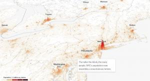
Today you’re going to see the best 3D maps in action. You can interactively fly around buildings and landscapes in three dimensions.
Chances are that you are already using Mapbox, and you may not know it! Apps like Snapchat integrate Mapbox directly into their applications.
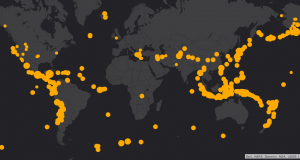
Carto is where data meets maps on the web. Instead of using desktop GIS software, Carto provides it all in the cloud with just a web browser.
Web App Builder (WAB) allows anyone to build powerful and highly-customizable GIS apps that can run on any device without any coding required.

We reveal the top 10 GPS apps for navigation (Android and iOS). Some apps will steer you away from trouble like crashes, construction and cops.
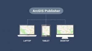
ArcGIS Publisher makes it easy to share digital versions of maps and data by publishing maps in PMF format that are accessible in ArcReader.
This is an introductory tutorial on how to create a customized web map in ArcGIS Online (AGOL) to visualize, share and collaborate on the web.