ArcGIS Pro Review: 17 Reasons to Map Like a Pro
All great software eventually evolves to modernize the user experience. It’s happened with ArcView 3. Then to ArcMap. And it will inevitably happen to ArcGIS Pro.
But why should you consider making the switch to ArcGIS Pro? Or will you migrate at all? Whether it’s the speed, slickness, or simply raw power, here are 17 reasons to make the transition to ArcGIS Pro now.
Pros/Cons of ArcGIS Pro
Here are some of the advantages and disadvantages of using ArcGIS Pro compared to other GIS software applications.
PROS
CONS
ArcGIS Pro Ratings
Mapping
Analysis
Editing
Data Support
Ranked #1 from 30 GIS Software
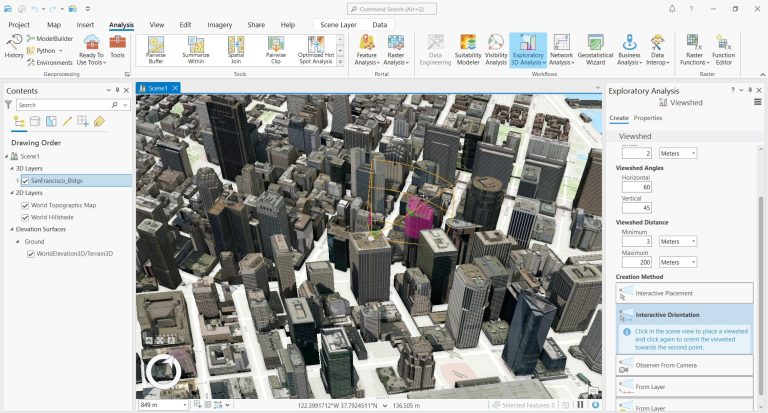
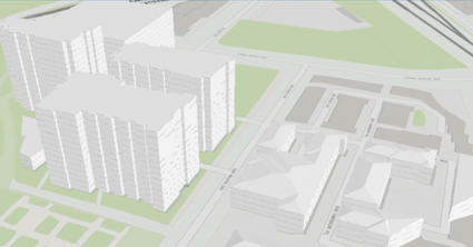
1. True 3D Integration with Local and Global Scenes
Remember when you had to open up ArcScene or ArcGlobe to look at 3D data? This idea is on the brink of extinction because of ArcGIS Pro. All of a sudden, 2D and 3D become unified. You can even synchronize or convert 2D with 3D. Or vice versa, 3D with 2D.
Now all things 3D are at everyone’s fingertips – editing, movie timelines, and web scenes. Whether it’s pipelines, utilities, or any of the 1000s of GIS applications, ArcGIS Pro propels these industries to the third dimension.
Admit it. It was a pain to move from ArcScene to ArcMap. You couldn’t even drag and drop layers from ArcScene to ArcMap. But all of a sudden, now your 3D data becomes seemingly integrated with ArcGIS Pro with local and global scenes.
And that is pretty neat.
2. Smart Contextual Ribbon Interface
GIS professionals (myself included) are hesitant to switch to ArcGIS Pro because all your favorite tools have moved!
But it’s actually the contextual tab interface that really adds to the user experience because it puts your favorite tools where you can access them easiest (even new ones). That means when you click a tab, the contextual interface only shows relevant tools that you can use.
For example, when you click a raster image in your table of contents, the view tab appears with tools like swiping and transparency settings. Instead of trying to find your effects toolbar, you can find common tools in its contextual ribbon.
Overall, when you play around with it more, you’ll realize that it means that you don’t have to search around as much to find the tools you need most. All things considered, the tab interface is the first thing you’re going to notice when you launch ArcGIS Pro. But once you get your bearings, it’s the biggest hurdle you’ll have to jump. And you’ll be glad you did.
3. Jack Dangermond-Approved Cartography
There’s something with ArcGIS Pro’s cartography that I can’t put my finger on.
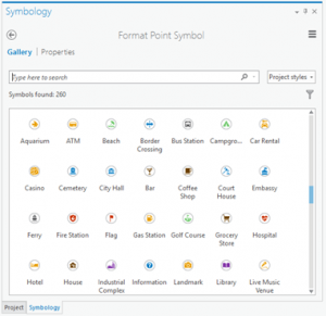
It may be its anti-aliasing that adds crispness to fonts and features. Or who knows, it could be the new transparency that really adds unique cartography effects to your maps. Either way, ArcGIS Pro has completely overhauled its symbology for a more stylish approach to mapping.
Remember when you had to click a dozen times to add a halo? When you click a features symbology in the table of contents, the symbology pane opens so you don’t have to go through all the boxes to change a symbol. It’s the same thing for labeling in ArcGIS Pro.
Using representations gives more flexibility with scale-based symbol classes. In other words, you can show predefined symbology at different scale ranges with unified symbolic representations (.STYLEX).
Whether it’s the crispness from anti-aliasing or enhanced transparency, ArcGIS Pro has redefined how to symbolize features in a map. To say the least, the enhanced cartography in ArcGIS Pro is its biggest advantage.
4. Think Projects (.APRX), Not Map Documents (.MXD)
ArcGIS Pro is not document-based but is project-based. But what does “project-based” actually mean?
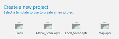
ArcGIS Pro projects (APRX) contain maps, toolboxes, databases, folders, and even styles. For example, projects can have multiple maps and multiple layouts in a single project. This also means that layouts are not tied to maps anymore.
You can work cohesively as an organization with projects because they contain your portal items and network files. It recognizes which folders, servers, and databases you access the most. Projects are much smarter remembering all your favorite network drives.
5. Build Realistic Rooftops in 3D
The parkour in you wants to use ArcGIS Pro for its 3D building tool. Measuring each building jump is a death-defying stunt.
I love the slick 3D rendering in ArcGIS Pro. When you apply a 3D layer, you can specify the roof type.
All you need is a normalized Digital Surface Model (nDSM) and the tool does all of the work.
This building is a 13-meter jump. What do you think? Could you make the jump?
6. Access ArcGIS Online with Ease
I am not too big of a fan of signing into your ArcGIS Online account (as a preliminary, required step) to work with ArcGIS Pro. Don’t get me wrong. Esri has built a well-oiled machine ArcGIS Online which allows users to sculpt maps and apps in the cloud.
If you’ve used ArcGIS Online, then you know how ridiculously simple it is to build web maps and apps that you can deploy for your organization. Whether it’s field, office, or community work, ArcGIS Online has an app for that.
After publishing 3D web scenes or 2D views, you can customize the code using Esri’s JavaScript API or use Arcade to specify symbols. In ArcGIS Pro, you can consume online credits from ArcGIS Online to do almost anything.
7. Faster Loading Imagery
Until now, consuming georeferenced products from drones like DJI and satellites has never really been a forte for Esri. However, ArcGIS Pro is starting to get a better handle on this challenging task.
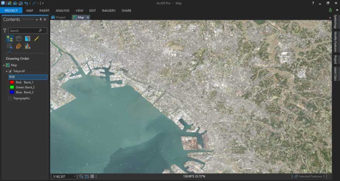
If you’re using drones at your organization, ArcGIS Pro is compatible with Drone2Map. This is a good thing when you have 3D data collected from a drone. (See #1 above)
When you’re sifting through satellite data, ArcGIS Pro recognizes XML files. But I couldn’t drag and drop it in the application. That would’ve been a bonus if you could like you can do with the SNAP toolbox.
8. Improved Editing Tools and Experience
Now that 3D is truly integrated with ArcGIS Pro, 3D editing also becomes so much easier. But it’s not only 3D, because ArcGIS pro augments most of the GIS editing tools and experience. For example, the default options are very different from what you’re used to seeing in ArcMap.
Instead of the default point-and-click, you can choose to create a polygon, autocomplete polygon, right-angle polygons, freehand, auto-complete freehand, and trace. With a wide area of editing options, it sure keeps the user experience in mind.
Because graticules are so easy to add to maps, it helps the user edit. Furthermore, ArcGIS Pro improves on the existing versioning tools, linear reference, and Data Reviewer.
9. Author Tasks as Business Processes
Have you ever written a step-by-step process in Microsoft Word for other people to follow?
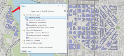
If you’ve done this before you may want to reconsider using ‘tasks’. Tasks involve preset steps for a repeated business operation.
For example, if your company performs field collection, you can consume it with a set of preconceived steps:
- Consume the data
- Turn on the editor with specific symbology
- Perform a quality control
Instead of writing this all down in a Word document, it would be a matter of authoring a task. This is what the city of Portland, Oregon did for their tutorial.
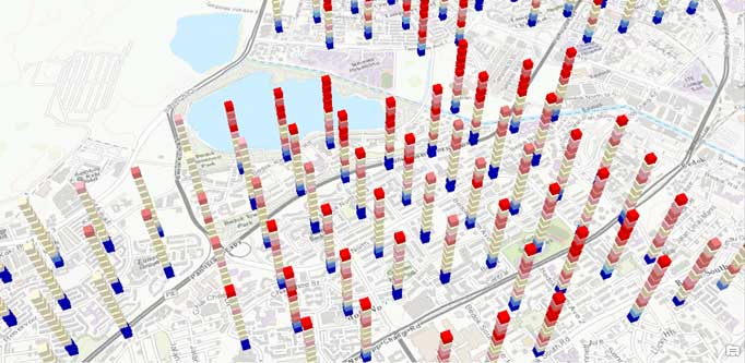
10. Chart Your Data Dynamically with Infographics
ArcGIS Pro introduced a new, innovative technique to add beautiful charts to your outputs. And this technique is all headlined under an infographic button.
While infographics do consume credits, they look professional and snappy, just what your audience needs. Student poster competitions will look 10 times more professional to get the edge you need to get the message across.
Charts are better designed in ArcGIS Pro. What’s important here is how these charts interactively update when you change your data in your project. Instead of having to manually update a chart when someone edits your data, it updates it dynamically for you.
11. The Python 3 and Conda Facelift
The majority of GIS professionals are accustomed to working with Python 2.7 for their automation needs. However, the one big facelift ArcGIS Pro takes is how it shifts to Python 3. It also differs from how Python is handled for you with Conda.
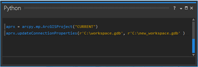
And it really makes sense to use Python because of its seemingly endless number of preexisting packages. But this is where Conda comes into play. In order to manage this versatility, Conda has a package manager application to install, run, and update packages and their dependencies.
Another notable change is how the arcpy.mapping module has been renamed to simply arcpy.mp. Other than this, the Python modules basically remain the same.
12. A Broader Range Remote Sensing Tools
Something that gets a bit less attention in ArcGIS Pro is how Esri broadens its horizons with its newly equipped remote sensing tools. For example, the vegetation indices include Normalized Difference Vegetation Index (NDVI), SAVI, and many more.
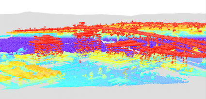
You could never really work well with LiDAR in ArcMap. To say the least, LiDAR has never really been its forte. That’s why extensions like LP360 exist to boost that functionality that you couldn’t get.
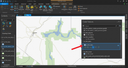
As you can see, consuming and viewing LiDAR in point cloud form is no longer a headache. When you add your LAS files into LAS data, all you have to do is move it to your 3D local scene.
13. It’s Faster than the Flash
OK, maybe not the Flash. But maybe his twin brother, who’s also fast. But not lightning-fast like the Flash.
ArcGIS Pro is multi-threaded. This means you can run processes and ArcGIS Pro is still responsive. The parallel processing, 64-bit ArcGIS Pro is for performance. However, the slick 3D rendering comes at a cost. Your machine demands better GPUs and RAM than previously.
In all honesty, a lot of the rendering clocked in slower in ArcGIS Pro. Albeit, a machine with low horsepower will chug and turn until you’ve had enough. But once you troubleshoot performance issues, it should give you the speed you’re searching for.
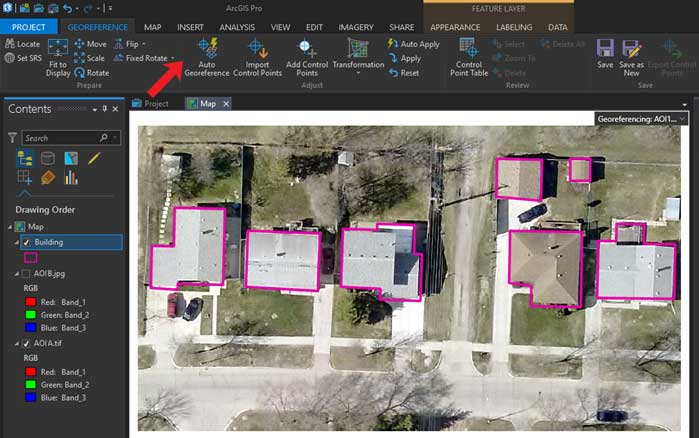
14. Georeference Like a Pro (with Automatic Georeferencing)
As soon as we heard about automatic georeferencing, we had to test it out. Most notably, what’s the accuracy in different environments?
We started in an urban environment with two similar images. Here is the georeferenced image with building footprints in pink.
Fully expecting the non-georeferenced image with sharp building corners to fit like a glove, the results were surprisingly grim:
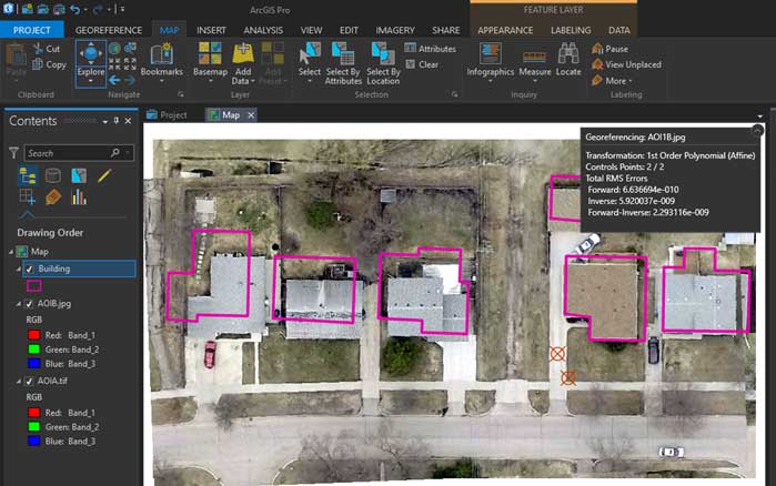
The tool had a hard time with real-world placement and this was the easiest of our tests. We decided to end things here.
Don’t get your hopes up too high with automated georeferencing. It’s a neat concept if you can do it right.
Update: I just tested this out again, and it turned out much better this time. Give it a try to see how it works for you.
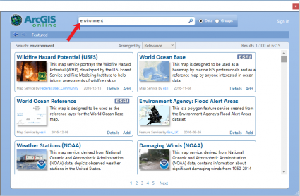
15. Access Untapped, Authoritative GIS Data
The capability to add KML and KMZ was one of the necessary steps for better interoperability. This is now a reality in ArcGIS Pro.
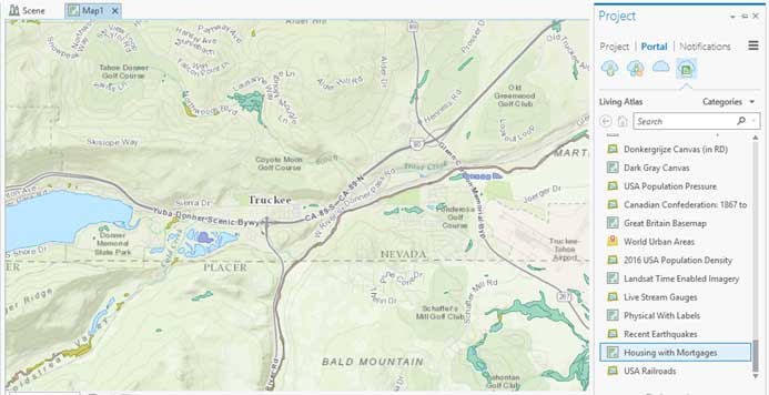
But it’s also data availability that’s expanded. Because of how you are connected to ArcGIS Online, you are always armed with the most up-to-date GIS data from around the world.
For example, the Living Atlas of the World curates geographic data from thousands of contributors around the world. After being stitched together, it serves as imagery, demographics, and transportation base maps for everyone to access.
As mentioned earlier, you can also work within your portal and grab your organization’s content. Because we are constantly sharing data amongst groups, the sharing tab is more prominent. You can even share geoprocessing tools as a geoprocessing package (.gpkx)
READ MORE: 10 Free GIS Data Sources: Best Global Raster and Vector Datasets
16. Random Things You’ll Learn To Love
You probably know how all the extensions you use on a day-to-day basis are fully integrated like 3D, Geostatistical, Network, and Spatial Analysis. But it’s about all the small things, where ArcGIS Pro finds room for improvement.
For example, the undo and redo are more intuitive. You can step backward and forward a lot more instinctively than you previously were able to.
Even the naming of tools is more intuitive. For example, instead of data-driven pages, a map book is now called a map series.
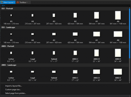
Everything looks stylish in ArcGIS Pro. How useful is it to see a map template preview before you create or print a new layout in your project?
17. All the 4D Space-Time Cubes You Can Dream Of
Stack blocks like they’re Lego. Each stack is a cube of time. Go up the stack of blocks, and see how things change in time. Older cubes are on the bottom and new cubes are on top. Put it in a 3D environment, you get a 4D space-time cube.
The concept is neat. We can now visualize how things change over time. For example, you can see emerging hot spot crime patterns with temporal data, such as intensifying hot spots, new cold spots, new hot spots, etc.
Sure, it’s for the 1% who use the spatial-temporal (4D) exploration tool. Some say they’d rather have them fix their 999999 errors.
All things considered, I think 4D space-time cubes are pretty neat.
Are you thinking of switching to ArcGIS Pro?
ArcGIS Pro didn’t reinvent the wheel but it’s a necessary facelift that transforms the way you do your work.
But at the same time, your GPU needs the raw power to get the software going.
ArcGIS Pro is part of the ArcGIS family of software. More than ever, Esri has been listening to your wants and needs in the Esri Ideas Forum.
Now, it’s your turn to let me if you are going to adopt it.
Let us know with a comment below.


Pro will not work for anyone with an unreliable internet connection.
I teach ArcGIS for health professionals who just want to map their data. I was excited to try Pro but I didn’t find it intuitive at all. Huge change from ArcMap. I tried making some basic maps in Pro for a colleague and after hours of trying to figure out how to add a basic shape file and finding no way to fix labels, I gave up and switched back to ArcMap. Hopefully Esri will fix the awful UI issues to align more with ArcMap before discontinuing it. Otherwise if I’m going to have to learn a slower and almost totally new program I will switch to QGIS. Esri needs to listen to the huge number of complaints online by their users. Pro is a hot mess.
Nice ESRI commercial!
Don’t combine general charts in ArcGIS Pro that you described with infographics. Infographics cost credits as they use business analyst/geoenrichment data. General charts (bar charts, scatter plots, etc) do not use credits.
I agree with Gord. It’s as if Esri have taken ArcMap and said “How can we take all the easy, intuitive functionality that exists in ArcMap, and make it as convoluted as possible? And while we’re at it, replace the simple mxd and with a whole aprx ecosystem with it’s own gdb, index folders, toolboxes and a whole bunch of other stuff that no one will use.”
Don’t like it!
How to buy and download ArcGIS Pro
Maps look fantastic in ArcGIS Pro. Only complaint is putting in definition queries. Seems to take a long. Also, projects seem a little bulky with all the files it creates. Still getting used to it.
ArcGIS Pro? Um… no thanks…and not anytime soon. If ESRI tries to force it upon everyone by discontinuing Desktop… then I will be jumping from the ArcShip pretty quick… I hear QGIS 3 is pretty bangin’ ;-)