10 Best Free Land Cover/Land Use Data
What are the top data sources for world land cover?
Over the span of your life, how much has the Earth changed? Quite a bit, but you probably just can’t put a number to it.
Thanks to global land cover and satellite sensors like MODIS, AVHRR, and Enhanced Thematic Mapper, we can finally shed some light on our changing planet.
But what global land cover data sets exist? What are the best?
What is their accuracy? How fine is its spatial resolution?
Seeing is Believing
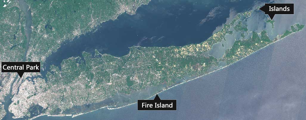
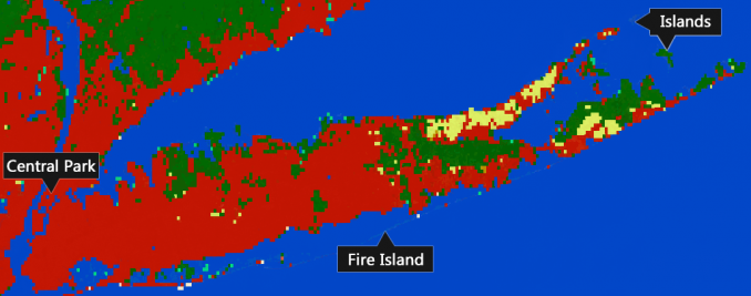
To help you follow along and get a visual understanding of the accuracy of the land cover classification, we produce screenshots of New York. Some of the key features to keep in mind are:
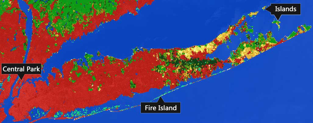
CENTRAL PARK: The square green space in Manhattan, the Jacqueline Kennedy Onassis Reservoir, and the Upper Bay that divides New York and New Jersey.
FIRE ISLAND: The thin barrier island off the southern shore protects the beach fronts of Long Island, New York.
LONG ISLAND: The islands in the northeast corner of Long Island like Plum Island, Great Gull Island, and Little Gull Island.
Here is New York in the eyes of Sentinel-2 pinpointing the features above.
How well are these features classified in the land cover maps? It’s not an easy task to classify the globe.
Read below for a summary of the various land cover classification schemes available for free at your fingertips.
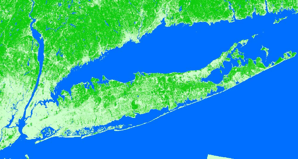
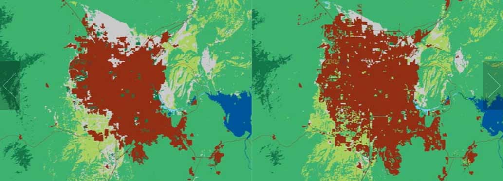
1. Esri Land Cover 10m
The Esri Land Cover (10m) is really the first solid effort to achieve a 10-meter resolution land cover using Sentinel-2. Although the spatial resolution is much greater than the other land cover products in the list, it still struggles in certain aspects.
But first, the Esri Land Cover dataset consists of 5 billion human-labeled pixels and is the result of training a deep learning model. This 10-meter resolution data source is open source and is available on the Living Atlas of the World by Esri.
The classes include built areas, water, trees, grass, crops, flooded vegetation, scrub/shrub, bare ground, snow/ice, and clouds. Overall, it’s the best global land cover available today because it uses the highest resolution spatial open data source. However, be cautious with the accuracy of roads, agriculture, and several of the other classes.
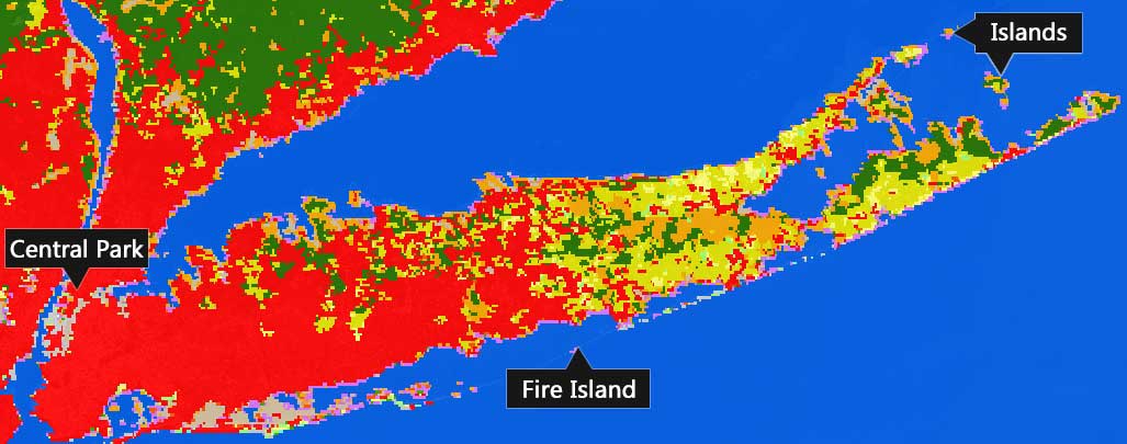
2. Global Land Survey (GLS)
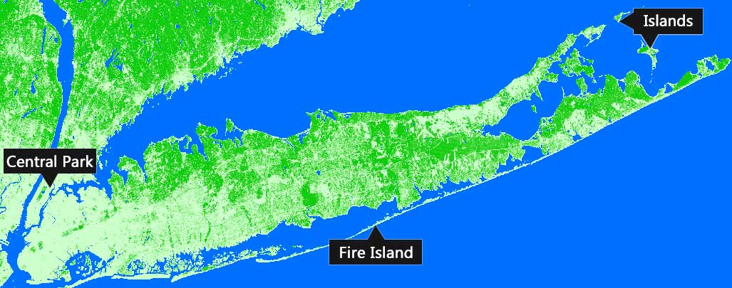
At 30-meter resolution, this land cover is one of the finest available. The University of Maryland teamed up with the USGS to lace together its circa 2010 tree cover, bare ground, and persistent surface water.
Using Landsat 7 ETM+ data, its most impressive attribute is its tree cover canopy described as a percentage per output grid cell. This canopy cover is used to weigh in global forest extent, loss, and gain from 2000 to 2012 such as this Global Forest Change web map.
Studies have shown that the overall accuracy of the Global Land Survey (GLS) static forest cover is 91% with forest cover change at >88%. Echoing the accuracy of this paper, Central Park and the outer islands are clearly visible. The lack of forested areas on Fire Island is consistent and logical. Things are looking good.
READ MORE: 4 Global Forest Maps to See the Forest for the Trees
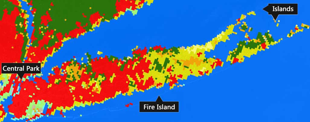
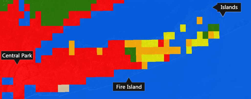
3. Climate Change Initiative (CCI) Land Cover V2
At 300 meter resolution, ENVISAT MERIS sensor is the biggest contributor to the 3 epoch land cover maps (1998-02, 2003-07, and 2008-12) of the CCI Land Cover V2.
By area proportions, it’s been cited to reach 73% accuracy for the 23-class land cover map. Additionally, the European Space Agency has created the ESA/CCI Land Cover viewer to dynamically view the land cover
Visually, you can see how it captures the thin barrier on the southern shore of Long Island. Despite missing most of the central park area (4km x 0.8km), it classifies the northeast islands impeccably.
4. OSM Land Use Data
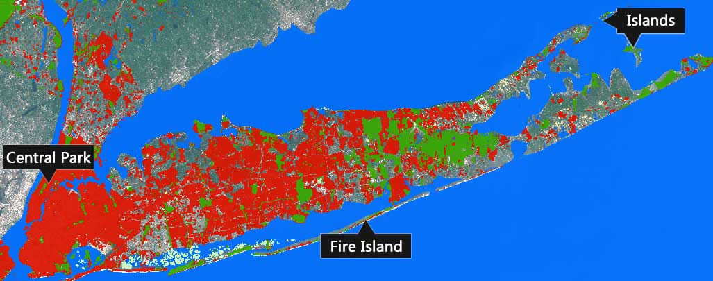
Every single land cover classification on this list uses image classification algorithms. But what happens if you were to use the data produced by the ginormous global community known as OpenStreetMap?
You get one ridiculously accurate land use map.
For example, the white square below represents a single-pixel of ENVISAT MERIS. If you were to select all the buildings from OpenStreetMap, you would count 157 buildings altogether.
On top of that, it tells you if it’s residential, commercial, industrial, or any other type.
In theory, you can create a solid land cover map with OSM data. The only downsides are the following:
- There are tons of data gaps.
- It probably won’t capture say a deciduous tree from a conifer.
- You have random people updating it. (with this said quality is quite good)
But in New York, OSM Land Cover reigns supreme. The outline of Central Park is picturesque. The southern shore and northeast islands are vectorized outlines. Pan over north a couple of times and the land cover is empty.
READ MORE: 10 Free GIS Data Sources: Best Global Raster and Vector Datasets
5. MCD12Q1 0.5 km MODIS-based Global Land Cover Climatology
The 500-meter MODIS Land Cover Maps (17 land cover classes) describe the dominant class based on a 10-year span (2001-2010).
Studies have shown inter-annual variability with 40% of pixels showing the change in class one or more times in the 10-year span. Because of its coarseness, it misses the mark on Central Park and Fire Island.
But Moderate Resolution Imaging Spectroradiometer (MODIS) captures the islands quite well. However, for all intents and purposes, it serves its job for weather and climate models.
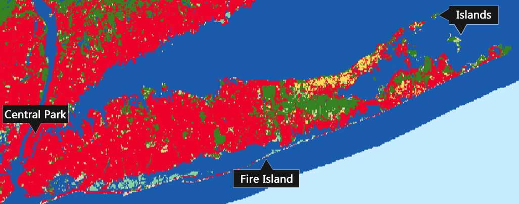
6. USGS – Global Land Cover Characterization (GLCC)
GLCC is based on a one-year Advanced Very High-Resolution Radiometer (AVHRR) using an unsupervised image classification approach. Based on the land area occupied, GLCC reaches a 66.9% accuracy.
When the observer can’t deduce a pixel as a “true” cover, this majority rule accuracy has an accuracy even higher at 78.7℅ throwing out those sites. This 1-kilometer pixel size land cover classification has classified Central Park. But it misses Fire Island and Plum Island completely.
7. GlobeLand30
In hopes of resurrecting the 2000 and 2010 30-meter land cover from the National Geomatics Center of China, it’s gone missing in action.
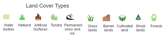
These 30-meter resolution land cover maps show the global distribution of 10 major land cover classes: water bodies, wetlands, artificial surfaces, cultivated land, permanent snow and ice, forests, grasslands, shrubland, bare land, and tundra.
It took over 10,000 Landsat satellite images to cover the entire Earth at 30 m resolution. This land cover uses pixel- and object-based methods and each class is identified in a prioritized sequence. In 8 selected areas, it achieves an overall classification accuracy of 80%.
We’re empty-handed for New York at the present time, but the data we have for other parts of the going looks fairly reasonable. To say the least, its disappearance is mysterious. Nowhere to be found at present, we’ll update the article when or if it’s back online
READ MORE: USGS Earth Explorer: Download Free Landsat Imagery
8. UN FAO Global Land Cover Network (GLC-SHARE)
The focus of the FAO’s GLC SHARE land cover is on land management. This is reflected particularly in some of its classes – cropland, grassland, bare soil, and mangroves. It includes artificial surfaces, water bodies, snow, treed, shrubs, herbaceous and sparse vegetation.
It’s coarse at today’s standards being a bit sharper than 1km grid cells. Further, it has an accuracy of about 80% with 1087 validation sites.
You can see how this classification completely misses Central Park, the majority of Fire Island, and the northeast islands. This is partly due to its coarse resolution.
Its primary use is for a better understanding of land management so we’d expect better results in agricultural areas.
9. Land Cover Type Yearly L3 Global 0.05Deg CMG
The Climate Modeling Grid has the same roots as MCD12Q1 using the same supervised classification-tree algorithm. This data set is available to download from the USGS Earth Explorer.
Although it generates the same 17 classes defined by the International Geosphere-Biosphere Programme, it’s at a much lower spatial resolution (0.05°).
At 5.5km pixels, you can’t get the precision level compared to all the other land cover options. For the average person, it’s hard to even recognize we’re looking at New York anymore.
10. Terrapop
Terrapop contains a variety of existing global land cover data sets from the already mentioned 23-class ESA GLC and MODIS 1km.
On top of that, it includes a very coarse agricultural land classification circa 2000 at 10km derived from the Global Landscapes Initiative. This contains the harvested area and yield of 175 crops to better understand agricultural supply and demand.
We give a tutorial in great detail on how to extract data from the intuitive Terrapop interface.
READ MORE: How to Get Harmonized Environmental & Demographic Data with TerraPop
Which land cover do you use?
Space agencies around the globe are launching satellites to meet the demand for an accurate land cover of the planet.
Our simple visual assessment of New York’s Fire Island shows how much land cover varies across providers.
It’s only at a finer scale, land cover can capture significant human activities on the land. Despite its significant gaps in data, there’s no land use as detailed as OSM.
Almost like tunnel vision, it’s surprising that scientists don’t use a multi-scale, multi-data iterative approach using the best available at a given location.


Quite a good information. Are the data free of charge, I mean the imageries, maps, DEM etc?
Yes, they are free of charge
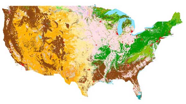
Wow! And what about the NLCD (NOAA-USGS)?
Eight epochs of land cover (2001, 2004, 2006, 2008, 2011, 2013, 2016, and 2019), a 2001 – 2019 land cover change index, and sixteen urban imperviousness datasets. FREE!
*Correct me if I’m mistaken but I don’t think NLCD is global, only US data.
It’s only for the United States – https://www.usgs.gov/centers/eros/science/national-land-cover-database
How do you miss the National Land Cover database? 4 epochs (2001, 2006, 2011, 2016) of Imperviousness (%), Land Cover (~16 classes), Tree Canopy (%; ’11 & ’16).
Hi,
Do you know a link for the download of the Global Land Survey (GLS) at the global level?
And thanks for the nice list!
Irene
I would like to download the global Land Cover layer, but I could not find the download link. I would be grateful if you could kindly help me.
Which one specifically are you referring to?