Merge Tool in GIS
DEFINITION:
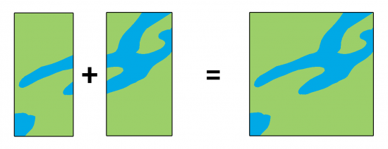
The Merge tool in GIS is used to combine two or more datasets (usually feature layers) into a single new layer.
What Is the Merge Tool?
The Merge Tool combines data from multiple sources, then adds them into a new data set.
It’s not only geometry, but it also merges attributes with the option to match fields from input datasets.
When you use the Merge Tool, features have to be the same geometry type (points, lines, or polygons).
Let’s take a look at the functionality of this geoprocessing tool.
How is the Merge Tool different from the Dissolve Tool?
The Merge Tool puts all the items from multiple datasets into a single dataset. But it maintains the boundaries between features.
This is different from the Dissolve Tool, which melts boundaries from one or more datasets into a common border. For example, dissolving the colored regions below generates 3 records of output.
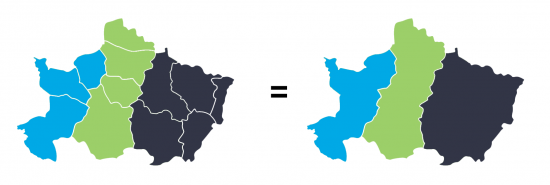
After running the Merge Tool, it creates a new dataset with all regional boundaries still intact.
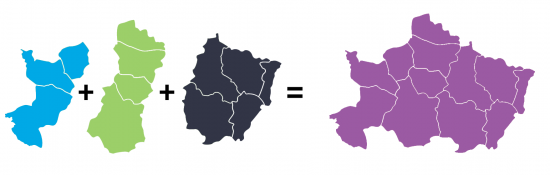
It’s similar to the Append Tool. But when you append data, it adds it to an existing dataset.
But merging takes two or more existing data sets and combines them creating a new data set.
Common errors and troubleshooting
When you run the Merge Tool, you can get a range of errors. Here are some of the common errors you get from merging and how to fix them.
FIELD VALUES – Merging two datasets will try to combine any fields with the same name. But if one field is a string and the other is numeric, you may get Error 001156 in ArcGIS. The way to fix this error is by renaming your field, or ensuring they are the same type of field.
MISSING OUTPUT – If the merged dataset has missing features, this happens when you have selected features before running the process. To fix this, you have to deselect features and run the process again.
INVALID SHAPE TYPES – You cannot merge different types of shapes for the Merge Tool. If you still want to run the tool, try to convert from points, lines, or polygons into a common shape type.
It’s also common to get geometry errors, including slivers, overshoots and undershoots. In this case, you can use some of the topology rules and conflation tools to automatically clean up some of these digitizing errors.
For troubleshooting 999999 errors in ArcGIS, there are common fixes on how to fix this error. This error is not unique to merging and can occur in most types of spatial analysis.

What are some examples of using the Merge Tool?
Merging is one of the most common geoprocessing operations in GIS because of the countless ways you can use it. For example:
- When teams are collecting samples, you can combine them by merging all samples into one.
- For neighboring regions with separate road datasets, merging can put them together into one dataset.
Remember that it’s always good practice to check for consistency between merged data. There are tools available to fix errors, including conflation and edge matching.
How to run the Merge Tool in ArcGIS
In ArcGIS and ArcGIS Pro, the Merge Tool is in the Data Management Toolbox and within the General Toolset.
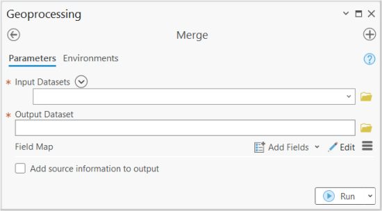
You can add your inputs and change your output feature class name.
The field map option is to match all the corresponding fields, so they’ll be combined together after running the Merge Tool.
How to run the Merge Tool in QGIS
In QGIS 3, you can find it in the Vector | Data Management Tools | Merge Vector Layers.
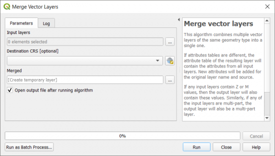
In both GIS software, the main entries are its inputs and output.
But in QGIS, you can specify the coordinate reference system.
But in ArcGIS, you can specify the field map, which identifies which fields will get paired during the merge process.
Summary
Merging works by combining datasets from multiple sources, and then assembling them into a new data set.
It’s the backbone of GIS and is one of the fundamental tools in our toolset.
How do you use the Merge Tool? What errors have you encountered?
Do you have any questions? Please let us know with a comment below.


“This is different from the Dissolve Tool, which melts boundaries from one or more datasets into a common border.”, this seems to be inaccurate. The Dissolve tool in ArcGIS melts boundaries from one dataset only. You would need to Merge/Append boundaries from other datasets into one before running the Dissolve tool.