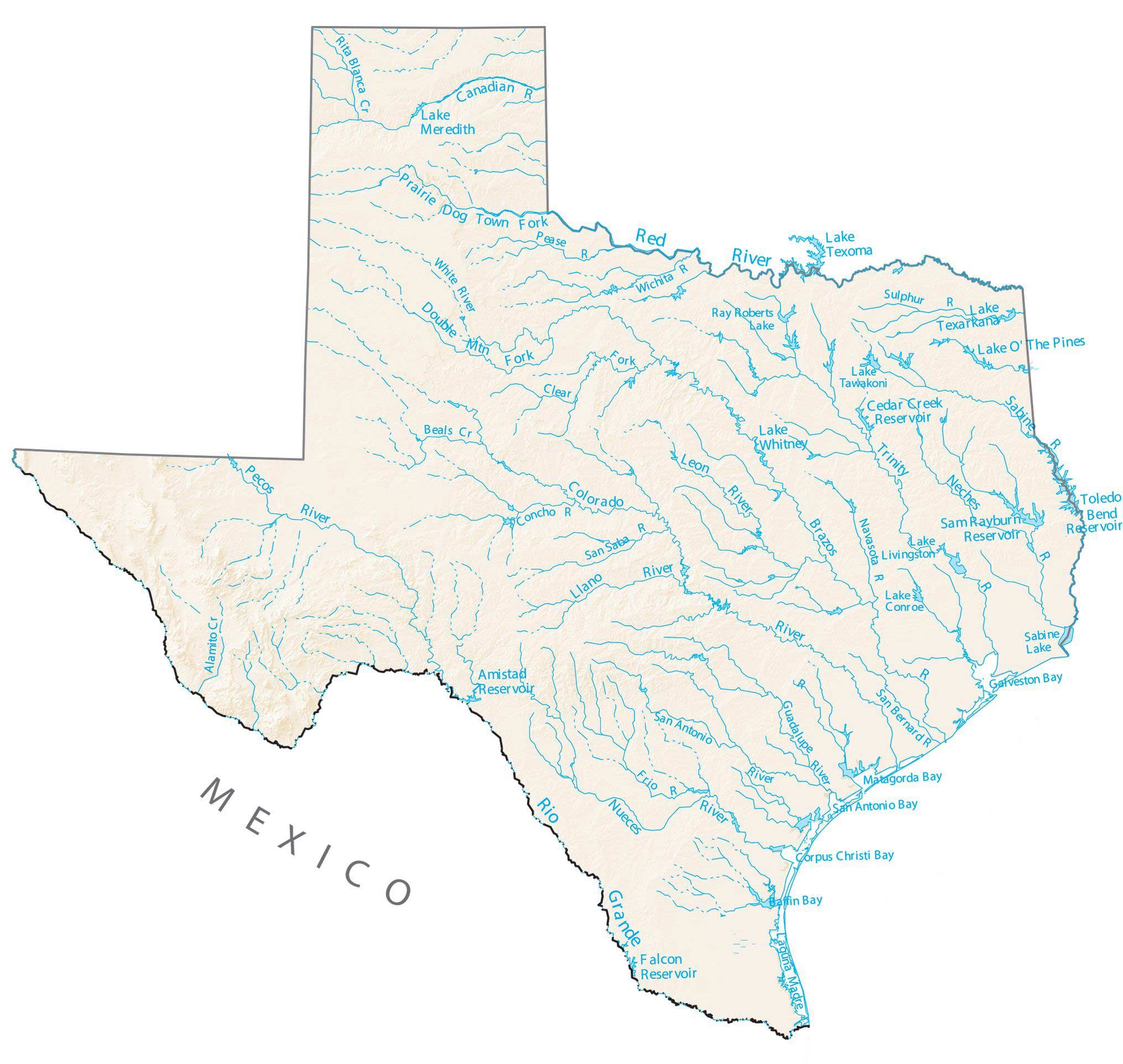
Texas Lakes and Rivers Map
About the map
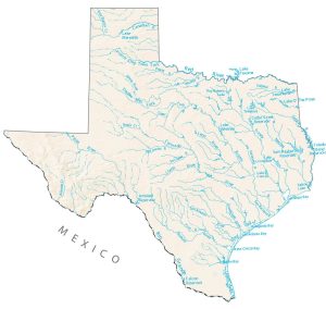
In this map, you will find major rivers, reservoirs, and lakes of Texas like Lake Texoma. It highlights natural and man-made lakes like Caddo Lake, Lake Travis, and Toledo Bend Reservoir. The map gives a clear view of how water flows across Texas, from the Panhandle to the Rio Grande.
Some of the major rivers in Texas are the Rio Grande, Pecos River, Nueces River, San Antonio River, and Guadalupe River. But the longest and most decisive is the Rio Grande, which flows for a total of 1,896 miles. In fact, it starts all the way north in Colorado. Then, it flows through Texas, separating a border with part of New Mexico and the country of Mexico.
Toledo Bend Reservoir, Sam Rayburn Reservoir, and Lake Livingston are the largest lakes in Texas. Toledo Bend Reservoir is a man-made lake shared between the states of Louisiana and Texas. Lake Texoma is another popular lake with over 6 million visitors per year for sailing, swimming, and fishing.
Texas map collection

You are free to use our lakes and rivers map of Texas for educational and commercial uses. Attribution is required. How to attribute?
Texas lakes, rivers and reservoirs
Lakes and reservoirs
Amistad Reservoir
Falcon Reservoir
Lake Whitney
Lake Texoma
Sam Rayburn Reservoir
Toledo Bend Reservoir
Lake Texarkana
Lake O’ The Pines
Cedar Creek Reservoir
Lake Meredith
Sabine Lake
Lake Livingston
Ray Roberts Lake
Lake Tawakoni
Lake Conroe
Rivers and streams
Pecos River
Nueces River
Rio Grande
Red River
Brazos River
Leon River
Llano River
Sabine River
Trinity River
Neches River
Canadian River
Colorado River
San Saba River
Frio River
Navasota River
Pease River
Concho River
San Antonio River
Guadalupe River
Rita Blanca Creek
White River
Beals Creek
Alamito Creek
Wichita River
Sulphur River
San Bernard River
Bays, gulfs and lagoons
Galveston Bay
Corpus Christi Bay
Laguna Madre
Matagorda Bay
San Antonio Bay
Baffin Bay
The map of Texas rear and steams is horribly inaccurate.
I want to buy a large edition of the lakes and rivers of texas map. Where is this possible?
If u were to look at a location from a map you think it’s so close but if you actually live it it’s like an hour away