World Geodetic System (WGS84)

WGS84 is standard for GPS
The Global Positioning System uses the World Geodetic System (WGS84) as its reference coordinate system.
It consists of a reference ellipsoid, a standard coordinate system, altitude data, and a geoid.
Similar to the North American Datum of 1983 (NAD83), it uses the Earth’s center mass as the coordinate origin.
Geodesists believe the error is less than 2 centimeters which is better than NAD83.
Pinpoint Your Position Using WGS84
When you need to accurately enter coordinates in a GIS, the first step is to uniquely define all coordinates on Earth.
This means you need a reference frame for your latitude and longitude coordinates because where would you be on Earth without having a reference to it?
Because the Earth is curved – and in GIS we deal with flat map projections – we need to accommodate both the curved and flat views of the world. Surveyors and geodesists have accurately defined locations on Earth.
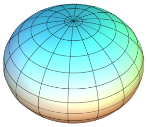
We begin modeling the Earth with an ellipsoid. To be clear, this is different from a geoid which is a measure of mean sea level. Over time, the ellipsoid has been estimated to the best of our ability through a massive collection of surface measurements.
When you combine these measurements, we arrive at a geodetic datum. Horizontal datums precisely specify each location on Earth’s surface in latitude and longitude or other coordinate systems. For instance, NAD27, NAD83, and WGS84 are examples of geodetic datums.
Using geographic coordinate systems, we can define positions on Earth. For example, we use degrees/minutes/seconds (DMS) and decimal degrees (DD) for spherical coordinates.
After we flatten the Earth with map projections, we use projected coordinate systems like the State Plane Coordinate System (SPCS) or UTM grid system.
WGS84: Unifying a Global Ellipsoid Model with GPS
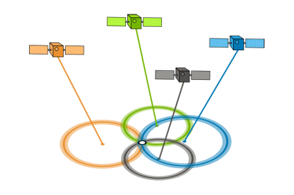
It wasn’t until the mainstream use of Global Positioning Systems (GPS) that geodesists first developed a unified global ellipsoid model.
The radio waves transmitted by GPS satellites and trilateration enable extremely precise Earth measurements across continents and oceans. Geodesists could create global ellipsoid models because of the enhancement of computing capabilities and GPS technology.
This led to the development of global ellipsoid models such as WGS72, GRS80, and WGS84 (current). The Global Positioning System uses the World Geodetic System (WGS84) as its reference coordinate system.
What is EPSG4326? EPSG4326 is just the way to identify WGS84 using EPSG.
It’s important to note that while WGS84 serves as a global reference, various regional geodetic datums might be more accurate for specific areas. In such cases, coordinate transformations are used to convert between different datums and the WGS84 reference frame.
Summary: World Geodetic System (WGS84)
Never before have we been able to estimate the ellipsoid with such precision.
This is primarily because of the global set of measurements provided by GPS.
WGS84 consists of a reference ellipsoid, a standard coordinate system, altitude data, and a geoid.
The error of WGS84 is believed to be less than 2 centimeters to the center mass.


Accuracy for those outside the US is a question as we need controls stations around the globe. Who is ready to invest in this, at least WAAS for Africa?
The best way to improve positioning integrity in Africa (and many other areas) is for countries to try and invest at least a single CORS (Continuously Operating Reference Station) into the global GNSS network — https://igs.org/. That would contribute to increased capability of processing GNSS positions with online utilities such as the US On Line Positioning User Service (OPUS) or the Australian AUSPOS which can provide cm-level results with sufficient observations from dual frequency receivers anywhere in the world.
“Geodesists believe the error is less than 2 centimeters which is better than NAD83.” In general this statement is not correct. It is true that WGS 84 defined as WGS 84 (G2296) is closely aligned to the International Terrestrial Reference Frame (ITRF) 2014 at the 2 cm level which NAD 83 (2011) is not. That being said WGS 84 does not deliver cm accuracy to those outside of the U.S. Defense Department as there are no high accuracy control stations directly available. On the other hand NAD 83 (2011) is easily available at the 1-2 cm level in the horizontal component anywhere in the U.S. through the network of Continuously Operating Reference Stations (CORS). It is important to note that a datum that delivers high accuracy positions and heights consists of a reference ellipse and some form of realization (passive or active control stations) – Additionally the ellipsoid WGS 84 has never been adopted by any international geodetic institution as the accepted system, that belongs to Geodetic Reference System 1980 (GRS 80). Without some form of ground based reference frame to connect to direct measurements from GPS have a general uncertainty of about 5 meters. Finally at this point in time it’s way more important to understand a relationship to ITRF since WGS 84 applies only to the U.S. GPS and not the other three positioning constellations that are in active use now. I am happy to respond to any comments on this topic — base9geodesy@gmail.com
Well done.
So good and clear.
Thank You
Hi. To what extent is the geodal shape of the earth ideal for establishing the datum for spatial referencing of a point on the global plane?
Very informative – all very new – am a retired air force navigator from the 70 – 80s long before GPS. Am learning marine astro-navigation and all these new terms exploded from the text.
Oh so different but logical.
Navigating at 6 nms a minute is slightly different and avoiding a lump of terra-firma a little easier than a shoal in the wrong place because the datum is old.
Hi I just want to know to what extent can geodesy be used to establish datum of the earth?
Hi
I just want to understand, how geodesy can be used as a basis for establishing datum? using the ITRS and WGS84 systems.
Hi,
Your page is quite informative. I am clearly trying to do something way out of my league. It seems I seem an astronaut and a cartographer for this one!
I’m trying to load WGS-84 coordinates into my render_list for an OpenStreetMap server I have. I can’t reconcile what numbers to use…
How does one find the proper Lat and Long conversion? (I’m trying to limit my server to rendering specific cities in depth.
I hope you can assist, thanks for your time:)
Thank you for the information. It is so useful for my report!!
Thanks, for this information it really enhanced me.
Where can I get data set for various datum?
Thank you
i found the information very useful for applying NOC from Airport Authority of India
I found the information very useful and beneficial to our survey work in the forest and will soon come up with a more comprehensive map output.