Free World Ocean Map
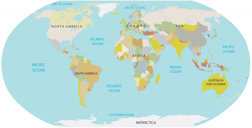
You are free to use our world ocean map for educational and commercial uses. Attribution is required. How to attribute?
Download our free world ocean map for any purpose (educational, nautical, or decorative).
- Educators can use it to teach children about the names and locations of the world’s oceans.
- Sailors and mariners can plan routes and mark areas of interest.
- Or simply use it as a beautiful wall decoration showcasing Earth’s five oceans.
The map includes all five of the world’s oceans:
1. Pacific Ocean Map
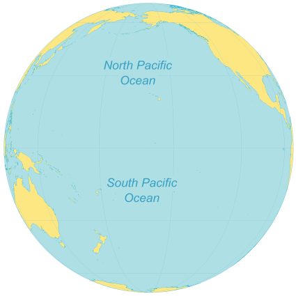
The Pacific Ocean is the largest ocean in the world, as well as one of the deepest. It stretches across approximately one-third of the planet’s surface, dwarfing all other oceans combined. The Pacific Ocean borders the Americas to the east, Australia and Asia to the west, and Oceania to the south.
The Pacific Ocean is home to many unique and fascinating sea creatures, including the Humboldt Squid and the Great White Shark. It is also the home of many incredible islands, including the Galapagos Islands and the Hawaiian Islands. Yet, beneath its tranquil surface, the Pacific Ocean boasts the Mariana Trench, the Earth’s deepest point, plunging to unfathomable depths.
The ocean is also home to some of the world’s most stunning scenery, from the blue waters and white sand beaches of Hawaii. Additionally, the Pacific Ocean has a rich cultural history, having been home to a variety of indigenous cultures for thousands of years. From pearl diving off the coast of Australia to surfing in California, the Pacific Ocean has long been an integral part of human experiences.
2. Atlantic Ocean Map
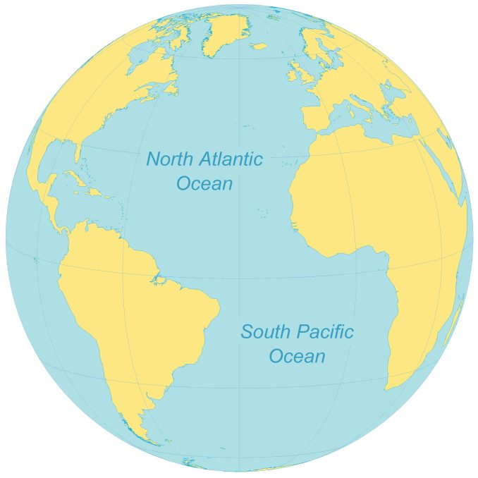
The Atlantic Ocean, a vast and dynamic expanse of water that separates the continents of North and South America from Europe and Africa, It is the second largest ocean in the world, as well as one of the most explored. It covers an area of approximately 106 million square kilometers (41 million square miles).
Many of the world’s most famous and important cities are located along the coast of the Atlantic Ocean, including New York City and London. It’s also the home of many incredible islands, including the Azores and the Canary Islands.
The Atlantic Ocean is also home to several important shipping lanes. The Panama Canal, which connects the Pacific and Atlantic Oceans, is one of the most heavily trafficked waterways in the world. Other major shipping routes include the Caribbean Sea and the Suez Canal.
3. Indian Ocean Map
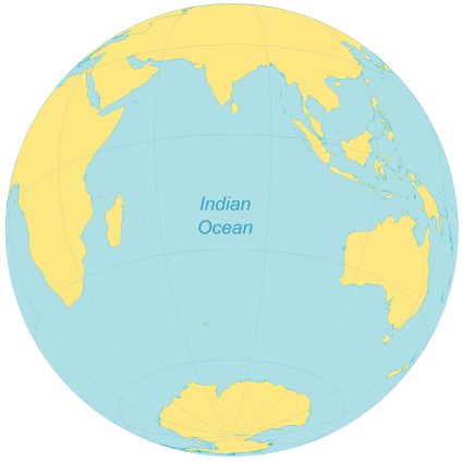
The Indian Ocean is the third largest ocean in the world, as well as one of the most complex. It spans an area of approximately 70 million square kilometers (27,243,000 square mi).
The Indian Ocean borders Africa to the west, Asia to the north, and Australia to the east. Many of the world’s busiest shipping routes run along the coast of the Indian Ocean, including the Suez Canal via the Red Sea.
The Indian Ocean is also the home of many islands, such as Mauritius and Madagascar. The Indian Ocean has the warmest surface temperature in the entire world, ranging from 19° to 30° Celsius. It is also home to a large variety of fish species and coral reefs, making it a popular destination for fishing and diving.
4. Arctic Ocean Map
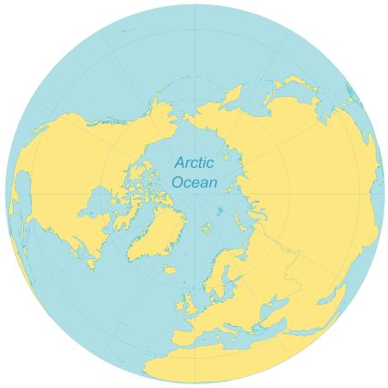
The Arctic Ocean is the smallest of the world’s oceans, covering an area of about 14 million square kilometers (5.4 million sq mi). It borders Canada and Alaska in North America, as well as Russia and Scandinavia in Europe and Asia. It also contains the islands of Greenland and Iceland.
The Arctic Ocean has a subarctic climate and is the coldest of all the oceans. It is home to a vast array of marine life, including whales, seals, walruses, fish, and seabirds, as well as a range of other species. It is also the location of the North Pole, making it the only ocean to cross the line of the Arctic Circle.
The Arctic Ocean also plays an important role in global climate change, as its icy waters help regulate temperatures across the globe. As temperatures continue to rise around the world, the Arctic Ocean has been particularly affected, with sea ice levels declining at an alarming rate. This has led to the displacement of many marine species, as well as the potential for an increase in shipping and oil drilling activity in the area.
5. Southern Ocean Map
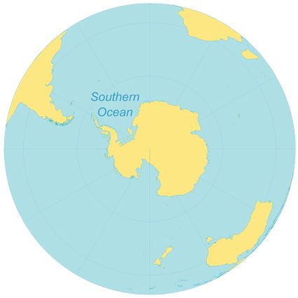
The Southern Ocean is the fifth and final ocean in the world. It consumes an area of approximately 20 million square kilometers (7.8 million miles). The Southern Ocean borders Antarctica in the south and Australia and South America in the north.
Many of the world’s most important research stations and scientific expeditions are conducted in the Southern Ocean, such as the Antarctic Research Station. It is considered to be one of the most pristine and untouched environments on the planet because of its wide range of wildlife, including whales, seals, penguins, and albatross.
One of the things that make the Southern Ocean so special is its extreme temperatures. It is one of the coldest and harshest environments in the world, with temperatures ranging from -2°C to 10°C. In addition to its incredible variety of sea life, the Southern Ocean is also known for its spectacular scenery and some of the most icebergs in the world.
The World Ocean Map
Explore the world’s 5 oceans with our world ocean map. Use it for education, decoration, or for any sailing adventure. Remember that you are free to use it commercially or for any purpose.
If you’re looking for more world maps, take a look at some of the other options we have below:
Was there anything that we missed? We’d love to hear from. Please send us your feedback in the comment section below.

Map 2: South Atlantic Ocean (NOT THE SOUTH PACIFIC)
Fixed it, thanks!