High Resolution World Map

You are free to use our high resolution world map for educational and commercial uses. Attribution is required. How to attribute?
High Resolution World Map
This is a world map showing the various countries, cities, and other locations around the world. It’s packed with information and is meant to serve as a reference guide to learning about different places in the world.
The World in High Resolution
What is a high-resolution world map? This high-resolution world map PDF is at 300 dpi with a large-scale dimension of 7000 × 3500 pixels. You can use this map for any purpose, provided you reference this page.
Africa Map
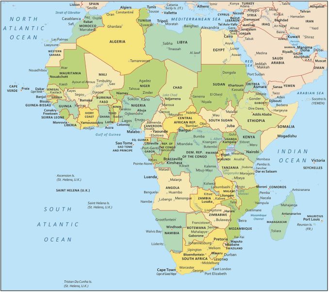
The African continent is the second-largest continent in the world and is home to some of the oldest human civilizations. Africa is made up of 54 different countries. Each of these countries has its own history, culture, and economic situation.
From the arid Sahara Desert to the lush rainforests of the Congo Basin, Africa’s vastness has both ancient histories and modern challenges.
Asia Map
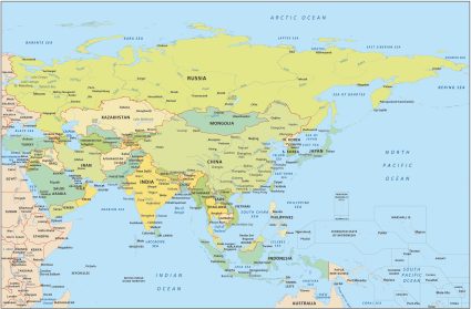
Asia is the largest continent in the world. It’s home to the world’s two most populous countries, China and India. The continent contains over half of the Earth’s population, as well as a significant portion of its land area.
Asia is a mix of ancient traditions and cutting-edge innovation. The region spans from the snow-capped peaks of the Himalayas to the metropolises of Tokyo and Mumbai. Its diverse landscapes, languages, and cultures continue to shape global economies and societies.
Europe Map

Europe is the world’s second-smallest continent in area, but it’s the third most populous. During the 1700s and 1800s, the Industrial Revolution began in Europe where many countries grew economically and socially around this time.
The European countries also host some of the world’s most famous landmarks such as the Eiffel Tower, the Acropolis, and the Colosseum. From Paris to Rome, Europe remains a historic crossroads of civilizations.
North America Map
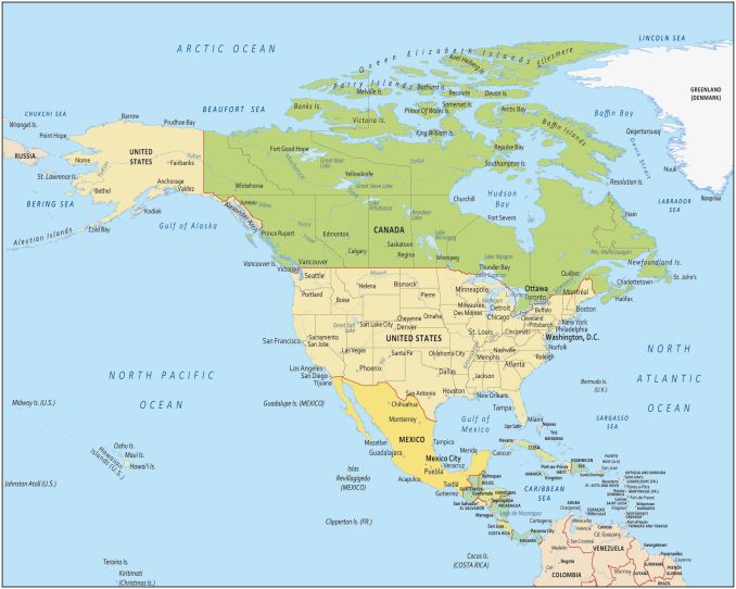
North America is the third-largest continent and is home to the United States, Canada, and Mexico. The continent is home to some of the world’s most striking and diverse landscapes.
For instance, it ranges from the desert landscapes of the southwestern United States to the Rocky Mountains. Mexico City, New York City, and Los Angeles are the most populous cities in North America and are also some of the most iconic cities in the world.
Oceania Map
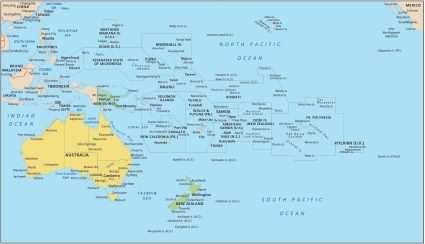
Oceania is a region consisting of Australia and neighboring islands like New Zealand. It also includes the Pacific Islands like Fiji, Samoa, Vanuatu, Kiribati, Solomon Islands, Tonga, etc.
Oceania is the smallest continent in the world and has the second-smallest population, after Antarctica. It comprises Micronesia, Melanesia, and Polynesia.
South America Map
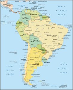
South America is the fourth largest continent, located mostly in the southern hemisphere. The continent consists of 12 countries and several territories.
Ordered by the most populous, the countries include Brazil, Colombia, Argentina, Peru, Venezuela, Chile, Ecuador, Bolivia, Paraguay, and Uruguay.
From its breathtaking landscapes to its cities like Rio de Janeiro and Buenos Aires, South America is also home to the Amazon Rainforest, the Andes Mountains, and the Amazon River.
Antarctica Map
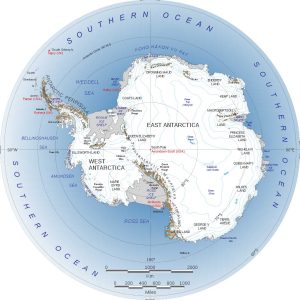
Antarctica is the third smallest continent in size. But it’s also the least populous with no one permanently living there. Antarctica is a frozen desert with very little precipitation. Not only is Antarctica the coldest continent in the world, but it’s also the driest place on Earth.
Antarctica is a place where scientists come to study its pristine natural environment, where adventurers come to experience the thrill of exploring one of the last remote frontiers on Earth, and where photographers come to capture its beauty.
World Map – High Resolution
This high resolution world map shows the countries of the world and their borders in great detail.
It is a great reference tool for students, teachers, and anyone interested in detailed maps of the world.
This world map can be used for both personal and commercial purposes, as long as a reference is provided.
Don’t forget that if you’re looking for more world maps check out our World Atlas and US Maps sections.
The descriptions beside the maps are selective and in some cases distortive. The description of North America skews heavily toward the U.S. The only specific example of a “striking and diverse landscapes” is the southwest U.S. desert. The Rocky Mountains are mentioned in a general sense, although they are a major range in Canada. And only U.S. cities are hyperlinked. Toronto is the 4th largest city in North America and is left out completely. This is clearly a U.S.-based resource.
Sydney is not there
Thanks! It is perfect for my craft!
Why is the map distorted in terms of sizes of some counties? Greenland is NOT that big
Because you can’t place the sphere’s surface flat!
Where’s Singapore?🤔
Hi Antilles- so many islands and countries are missing. Love the clarity of the map and that is was free to download thank you.
Wow! This map is nicely detailed. Very easy to find things.
England, Scotland, Wales, Ireland ? All seperate Countries yet omitted. British Isles, United Kingdom are not countries. They are groups of countries.
the map uses the sovereign state concept with countries having a seat at the UN. because the UK acts as a single entity for diplomacy, defence and passport issuance, it is represented as one block. Also there are the limitations of space for a small country, compared with say the USA, which is why on the north american continent you may see US states and canadian provinces, but you won’t see member countries of the UK or counties on the europe map.
Good map
Really clear view when zoom the map.Nice.
very useful world map 👍
Map needs updated! Gulf of America.. and prep for this one…Greenland-Red white and blueland. 😝 https://www.congress.gov/bill/119th-congress/house-bill/1161.
This comment aged well.
high-resolution world map PDF is at 300 dpi with a large-scale dimension of 7000 × 3500 pixels!!
How can I download it?
The download link at the top of the page only provides access to a JPG file.
I can give you a 4000×2000 JPG – https://gisgeography.com/wp-content/uploads/2022/04/High-Resolution-World-Map.jpg
Right-click and download. That’s the best we have available
These are beautiful maps.
Do you have any advice for how large we could have them printed for a classroom wall without losing clarity? Very happy to post an attribution!
I need a world map on our church website with our missionaries.
Do I need to pay for this image?
No need to pay. Please feel free to use it and make sure to cite it.
W map bro, ts helped me with geography 🔥 🔥 🔥
Thanks for sharing the maps, they are very helpful along the learning journey.
There is no country called N.Cyprus. The country is called Cyprus and it’s an EU member since 2004 ! ! !
This map is great!! Everything I need for my class. However, is there a version that has Ukraine correct, with Crimea? Thanks
why is mostly nothing labeled
Are you serious
I think you’re the best in offering free hd maps I like it. thank you so much..
Very knowledgeable with the simplest explanation. Thank you so much. Its very helpful for me
Hello
My family really do like & appreciate your world map. I would like to print & paste it on the wall for educational purposes. Can I have the High Resolution of the world map, with reference of course ?
When downloaded, it is only at 847 kb & its way to blur when I print it to a reasonable size ( to place on the wall) …
Thanking you in advance.
Yes, you can. Please click the “Download” button for a high resolution version of the map.
From your website:
“North America is the third-largest continent and is home to the United States, Canada, and Mexico.”
“South America is the third largest continent, located mostly in the southern hemisphere.”
Hmm. Don’t see how these two statements could both be correct. So I checked elsewhere. Would be much easier to read if you just put them in order and left out “the second smallest” references. You need a rewrite to be less confusing.
1. Asia; 2. Africa; 3. North America; 4. South America; 5. Antarctica; 6. Europe; 7. Australia/Oceania
Yes, you’re absolutely correct. Thanks for the tip, and I’ve updated the article
Can you please advise how I can get a PDF copy of the map? It only downloads to a JPEG file?
Many thanks
How can I get the pdf file?
Good map of the world 🌍
How do you convert latitude and longitude coordinates to pixel locations?
Asked on StackOverflow too, https://stackoverflow.com/questions/77669624/how-to-convert-latitude-and-longitude-to-gisgeography-world-map-pixel-locations
Looks great. Thanks, Hans
Howdy, guys🙋♂️ Good map 🗺️🗾
Seychelles, Maldives, etc.?
Hi. Where is Singapore
Your team did fantastic work. I used the map in a presentation and also gave a reference showing where I got the high-resolution map from. Thanks
Perfect, thanks.
It is the best map I found online. Thank you so much for it, God bless!
Why no mention of Russia? On the map, it looks larger than Asia.
Hi, you didn’t put names on the map of Bosnia & Herzegovina and Kosovo!
I appreciate your work guys!
Crimea belongs to Ukraine, not Russia according to international law. Also Taiwan is a different colour from Mainland China, which is also an issue (Taiwan is still not widely internationally recognized as an independent nation).
Is there a similar map that corrects the Crimea error?
Thank you, this will stretch my son’s knowledge more and prolong his interest.
Thank you as I tutor elementary students re: state, country, and world
Thanks alot. This would be so useful.
I think it’s right under where it says ALPS.
Looks like this map is missing Switzerland, right?