ERDAS Imagine – Earth Resources Data Analysis System
ERDAS Imagine Software Review
The year was 1978 when ERDAS Imagine (ERDAS 4 at the time) was first launched using a hard drive the size of a small washing machine. Up to the present time, ERDAS Imagine has been re-worked and is still one of the best in the business
While it excels in being user-friendly, the tab interface helps keep all your tools in order. Today, we highlight why ERDAS Imagine is Hexagon Geospatial’s flagship image processing software.
1. The Intelligent Viewer
The viewer is sharp, it’s expandable… Not to mention, it has an uncanny ability to read any format you throw at it. For example, it’s compatible with a range of satellites like Landsat, Worldview, Sentinel, SPOT, and AVHRR.
This means that it’s intelligent enough to read your image and deliver canned composites. Equally important, you can organize the spectral bands as you choose for composites of your own.
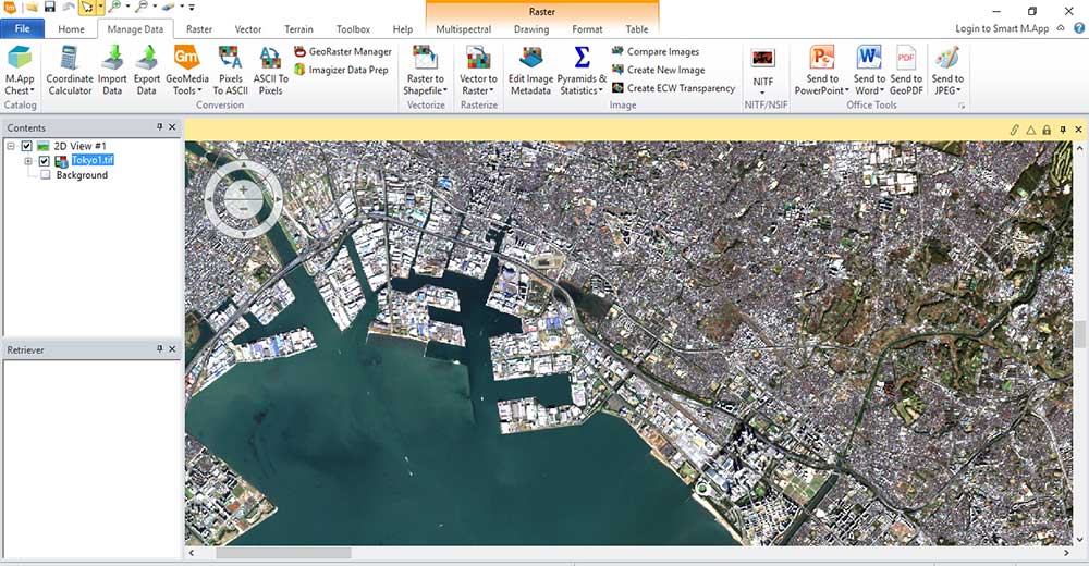
ERDAS Imagine will pan-sharpen your image for crisper outputs given a panchromatic band.
READ MORE: 15 Free Satellite Imagery Data Sources
2. LiDAR Tools
Light Detection and Ranging (LiDAR) is the new authoritative data set.
LiDAR actively sends light energy to the ground. It measures reflected light in time back to the sensor to get the distance. For this reason, LiDAR gives an accurate snapshot of the ground elevation and its features.
ERDAS Imagine handles LiDAR in its native form (LAS). As a matter of fact, you can drag and drop a LAS file in the viewer to see and edit the point cloud.
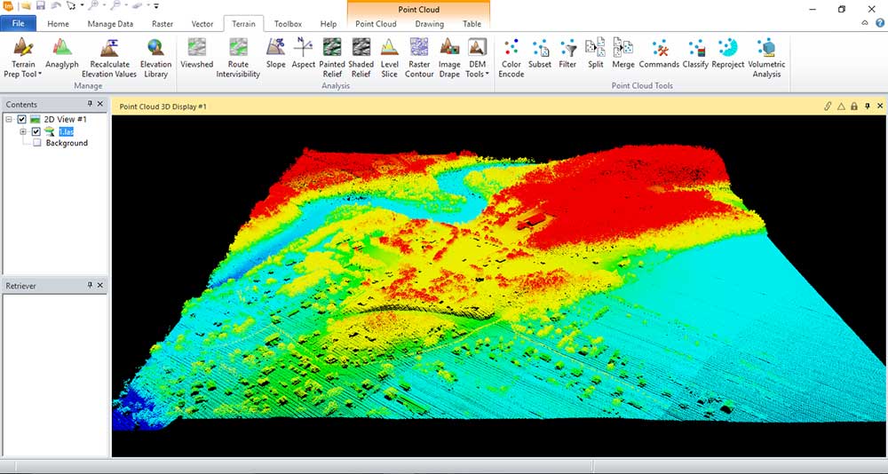
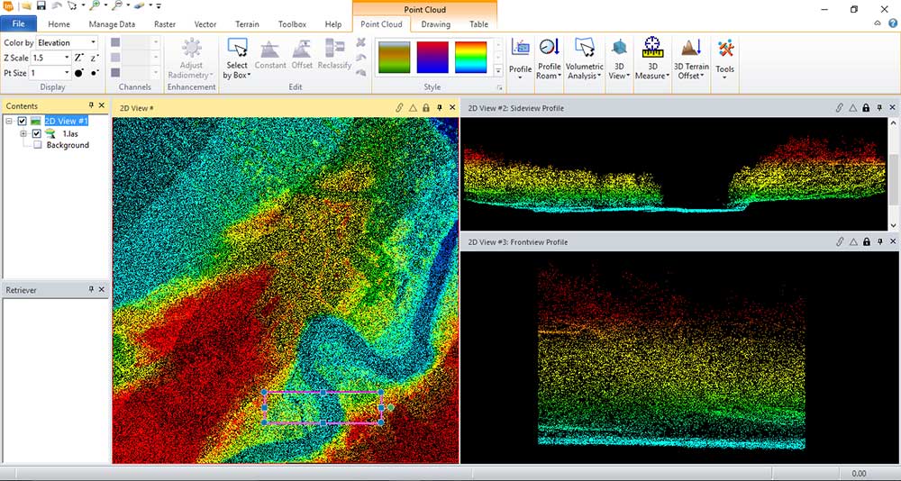
It can render point clouds in 3D. Also, you can view the intensity, classification, elevation, and various returns.
The LiDAR profile side view is slick. You also get a front view which is also neat.
As LiDAR expands in usage, ERDAS Imagine adjusts to its growing demand
READ MORE: Top 6 Free LiDAR Data Sources
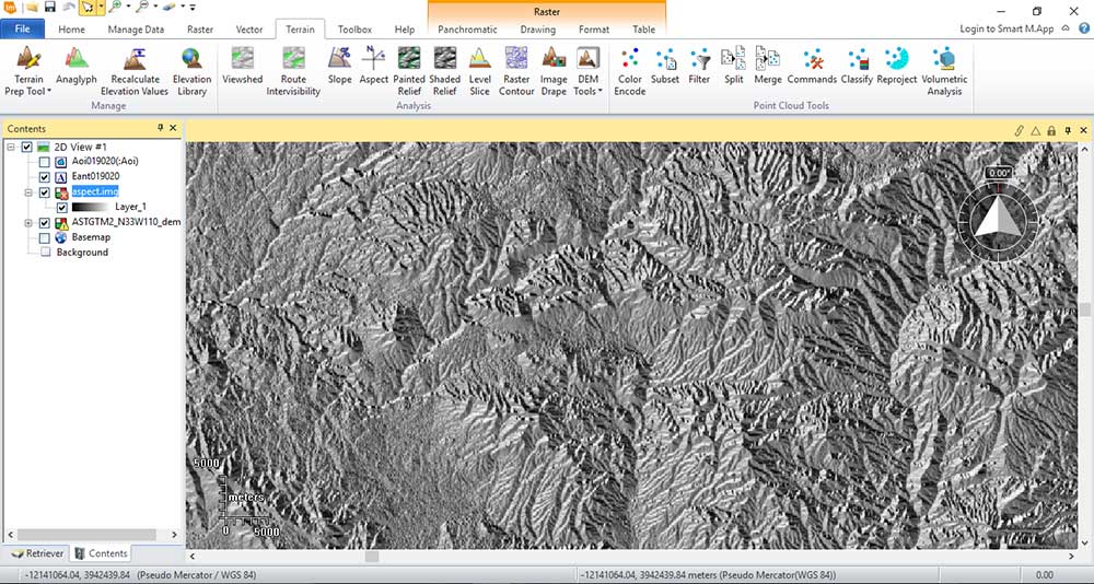
3. Terrain Tools
Whether you have a photogrammetric, LiDAR-based, or InSAR digital elevation model, ERDAS Imagine can perform most types of terrain analysis.
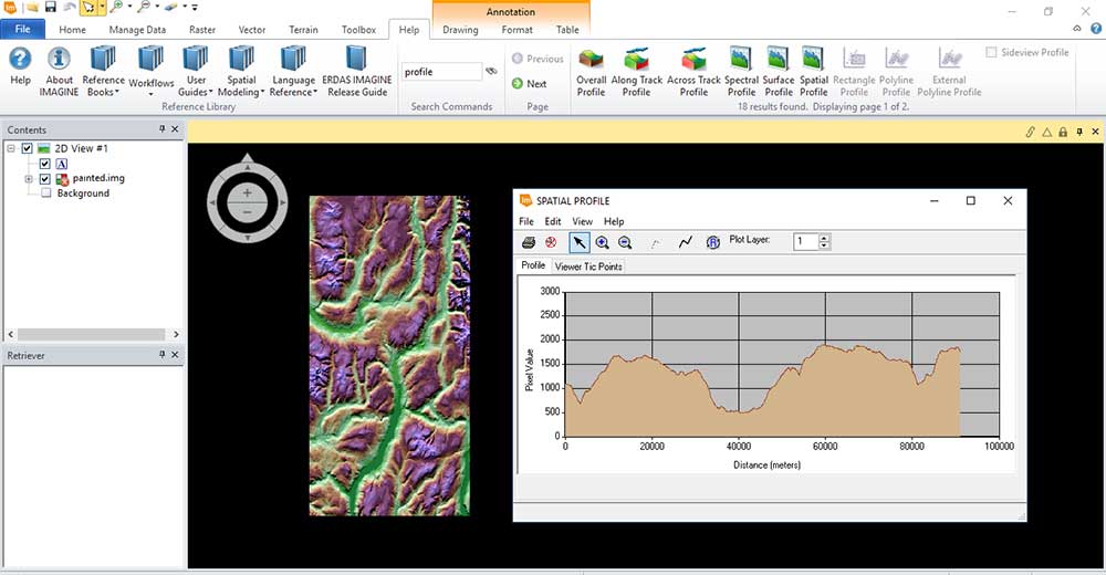
The painted relief raster splits elevation into color ranges. It paints each range based on its elevation as in the example below. We’ve also included a side-view profile in this example.
ERDAS Imagine can generate your basic slope, aspect, contours, and viewshed types of maps. Additionally, it has geoscientific tools to remove void areas, extract valleys and ridges, and drape images in a virtual GIS viewer.
You will need an additional license for a stereo analyst. With the stereo analyst extension, you will be able to collect and measure 3D features using photogrammetric principles from stereo pairs of imagery.
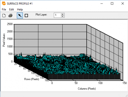
ERDAS Imagine has a tool that slices your elevation data into a user-defined number of bins, each containing the same amount. It also has a tool to visualize the z-values (or reflectance spectrum) of a rectangular area such as the surface profile below:
READ MORE: Free Global DEM Data Sources
4. Spectral Tools
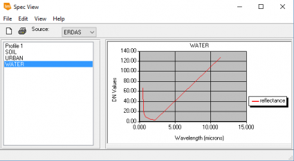
Every feature on Earth has its own unique composition. It reflects and absorbs red, green, blue, near-infrared, and different types of energy. This means that each feature has its own spectral signature.
With this idea in mind, researchers are building spectral libraries cataloging the unique characteristics and compositions of minerals, vegetation, and more. ERDAS Imagine lets you dig deeper into this subject with a spectral profile library of its own – similar to the USGS Spectral Characteristics Viewer.
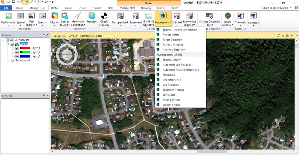
With more spectral bands (such as with hyperspectral data), you have a greater opportunity to classify more features with greater accuracy. Although hyperspectral data is hard to come by, ERDAS Imagine provides wizards for hyperspectral analysis.
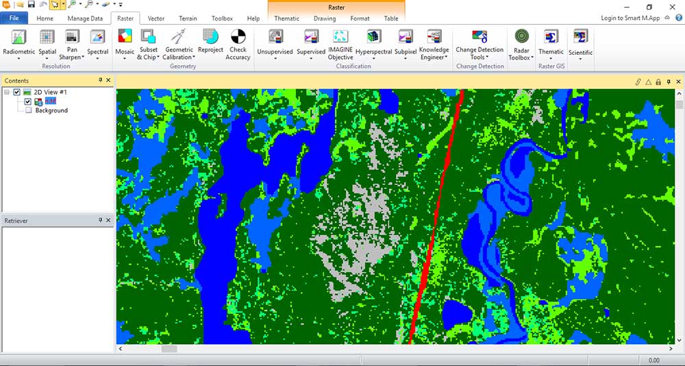
There are tools for supervised and unsupervised classification. Despite its impressive image classification tools, you won’t be able to perform object-based image analysis like you can using Trimble ECogntion Definiens Developer.
There are no shortages of indices in remote sensing – NDVI, SAVI, GNDVI, RVI, MSAVI, DVI… Even for different materials like vegetation, sulfates, water, snow, and ice.
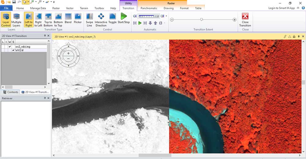
As long as you have the needed bands, you can extract this data from your multispectral image. For example, here is a quick NDVI image:
READ MORE: What is NDVI (Normalized Difference Vegetation Index)?
5. Radar Tools
A whole other discipline in remote sensing is active sensors like synthetic aperture radar. For example, Sentinel-1, Radarsat, and TerraSAR satellites can be imported in their native form.
Quickly view data by simply dragging the product.xml into your workspace
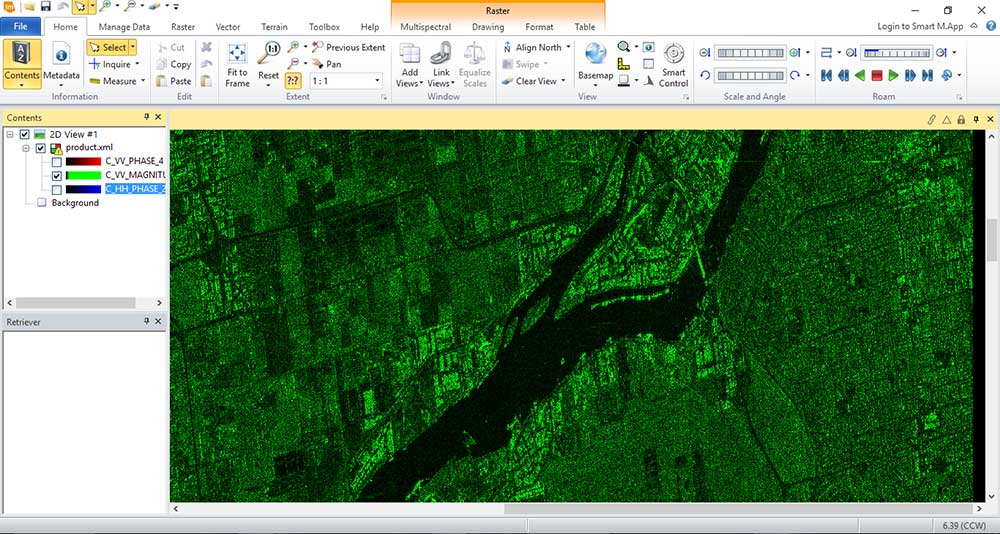
ERDAS Imagine has the Radar Toolbox to satisfy the needs of synthetic aperture radar users. Despite its complexity, ERDAS Imagine can perform interferometry for DEM extraction, texture analysis, and polarimetric classification.
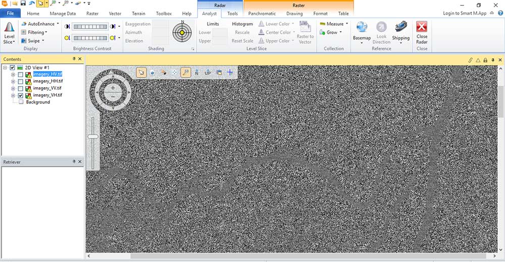
Overall, this software makes it easy for the user to manipulate radar data
6. Spatial Model Editor
The Spatial Model Editor is where you string a set of tools together. When you run them all together, you can automate your work. Similar to ArcGIS Model Builder or an FME workbench, Spatial Model Editor lets you streamline and customize a repeatable way of getting the answer
For example, here is a LAS to raster conversion. In case you receive another LAS file, you can recycle your model and produce identical results with a different file.
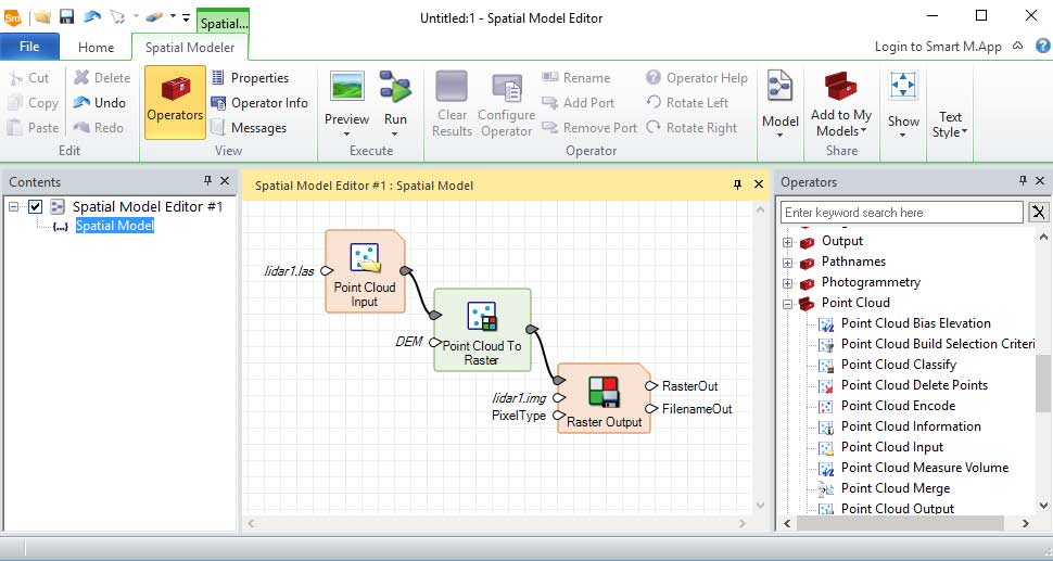
The Spatial Model Editor is versatile and intuitive. Best of all, you can pick it up and learn effortlessly.
Although part of Hexagon Geospatial GeoMedia software, the Spatial Model Editor can manipulate and manage satellite and aerial imagery as well.
ERDAS Imagine History
Here are some of its key dates of release:
- First, its initial release came in 1978 with ERDAS 4. In addition, it was run on Cromemco microcomputers with options for large digitizing tablets and 80-megabyte hard drives.
- Following its previous release, ERDAS 400 was introduced in 1980. At the time, computers were expensive and were being used by organizations such as NASA, the US Forest Service, and the US Environmental Protection Agency.
- In 1982, ERDAS 7 was launched which sparked a collaboration between ESRI ARC/INFO. Users were able to connect remote sensing with the power of GIS mapping.
- Finally, the flagship ERDAS Imagine software product was introduced which it is still named today. Another key point is how the graphical user interface allowed users to visualize data, create maps and perform image processing.
It’s now part of Hexagon’s product suites which include Hexagon GeoMedia, Leica Geosystems, and M.App Enterprise.
Final Thoughts: ERDAS Imagine
ERDAS Imagine is one of the first remote sensing software programs.
…And it’s still one of the best.
This robust raster-based GIS suite provides a wide array of tools for geospatial analysis: import/export, map composition, image enhancement, image classification, raster GIS modeling, and photogrammetry.
What do you think of ERDAS Imagine? Let us know with a comment below.


I love the history lesson. I started working with as of Erdas 7.5 at the prompt on pdp-11 and loved it from the start. Still working and teaching with Erdas Imagine…
I wonder if there is a version history. When did the radar tools come up?
I began working for Erdas, Inc. in 1986. At the time it was a start up company in an incubator facility on the campus of Georgia Tech University. The company was started by Lawrie Jordan and Bruce Rado, two amazing individuals. Both graduated from the Harvard School of Design (Landscape Architecture) under Dr. Carl Stienitz, maybe the first professor to teach GIS concepts in the U.S. Another classmate was Jack Dangermond. Lawrie and Bruce left Harvard to found Erdas, Inc., while Jack founded Esri. At the time, Erdas was a command line computer package that ran most efficiently on a PDP-11 or Microvax computer, although the software was transitioning to the DOS based personal computer, with a maximum hard drive capacity of 32 MB. Data was obtained on 9 track tapes, which were delivered to users through the mail, in response to a paper form and paper check, mailed to the data provider. Erdas Imagine was released in approximately 1989, I believe. There was much discussion about the product name and the entire company (about 50 employees) weighed in on the new name. The Erdas logo was branded in red one night when Lawrie and Bruce were looking out the window of their new office to see the headquarters of Coca Cola, in downtown Atlanta. They decided if red was good enough for Coke, it was good enough for Erdas. After much success, the company was sold to Intergraph. Lawrie went on to lead the remote sensing division of Esri, where he reunited with his classmate Jack Dangermond.
Very informative. Thanks.
The article is right.. unfortunately ERDAS still doesn’t let you perform an hierarchical OBIA, it means you can work with only one level of heterogeneity per time.. Anyways.. AM is a great software
Great article, but I have to agree with Mr. Joe Penor.
ERDAS Imagine have the IMAGINE Objective Add-on module for object-based classification.
Well… I have to say the article is pretty good except you are wrong with the object based classification. The ERDAS IMAGINE Objective add-on is object based and has shown to be equal to eCognition. Give it a shot.