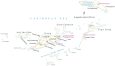
British Virgin Islands Map

This British Virgin Islands map (BVI) contains satellite imagery, settlements, seaports, bays, islands, points, harbors, and its international airport. It features satellite imagery to view the island nation in the Caribbean Sea.
British Virgin Islands map collection
About the map
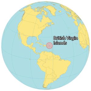
The British Virgin Islands is a territory in the Caribbean Sea next to the US Virgin Islands and Puerto Rico to the west. It consists of its 4 main islands as well as 50 smaller islands and cays.
Its 4 main islands are Tortola in the center, Virgin Gorda to the east, Jost Van Dyke to the west, and Anegada about 25 kilometers to the east.
Road Town is the capital and largest city of the British Virgin Islands on the island of Tortola. But Spanish Town is the second largest settlement on the island of Virgin Gorda.
The territory is known for its sailing, beaches, diving, and offshore banking. Its main international airport is the Terrance B. Lettsome International Airport on Beef Island in the east.
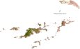
SATELLITE IMAGERY
British Virgin Islands Satellite Map
The British Virgin Islands occupy a total area of 153 square kilometers (59 sq mi). In comparison, it’s smaller than Aruba but larger than Anguilla. Most of the island’s origin is volcanic with hilly and rugged terrain. At 521 meters (1,709 ft), Mount Sage is the highest point on Tortola Island.

The main island consists of drought-resistant forest with its largest settlements along the rim including Roadtown. The territory is part of the Virgin Islands archipelago. Additionally, it’s within the Leeward Islands of the Lesser Antilles and part of the West Indies. The collection of islands lie between 18°15′ and 18°35′ so its climate is tropical rainforest but influenced by the trade winds.
Capital City
Roadtown
Major islands
Great Tobago
Little Tobago
Anegada Island
Great Camanoe
Virgin Gorda
Jost Van Dyke
Tortola
Scrub
Beef
Ginger
Cooper
Salt
Peter
Norman
Great Thatch
Populated places
The Settlement
Great Harbour
Fahie Hill
Long Look
East End
Parham Town
Spanish Town
West End
Water
Caribbean Sea
Sir Francis Drake Channel
Mountains and peaks
Gorda Peak
Sage Mountain
Places of interest
Terrance B. Lettsome International Airport
Virgin Gorda Airport
H. Lavity Stoutt Community College
Auguste George Airport
Bays
Carrot Bay
Brewer’s Bay
Cane Garden Bay
Sea Cow Bay
Caribbean


