Map of Europe (Countries and Cities)

About the map
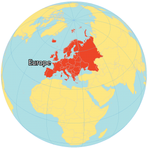
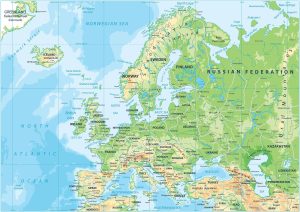
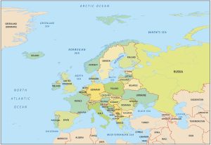
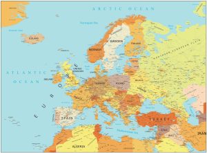
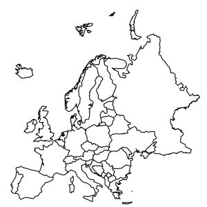
This map of Europe displays its countries, capitals, and physical features. Each country has its own reference map with highways, cities, rivers, and lakes. Europe is a continent in the northern hemisphere beside Asia to the east, Africa to the south (separated by the Mediterranean Sea), the North Atlantic Ocean to the west, and the Arctic Ocean to the north. Europe occupies the westernmost region of the Eurasian landmass.
Two major peninsulas are the Iberian Peninsula, which contains Spain and Portugal, as well as the Italian Peninsula. Scandinavia is the northernmost trio of countries including Norway, Sweden, and Finland. Whereas islands like Iceland, Britain, and Ireland extend into the North Atlantic Ocean.
Because the Ural Mountains mark Europe’s eastern boundary with Asia, Europe includes part of Russia. This includes its most populous cities, Moscow and Saint Petersburg. Otherwise, the Caucasus Mountains and the Turkish Straits mark Europe’s southern continental border with Asia.
Europe Map Collection
Western Europe


Northern Europe


Southern Europe


Capital Cities
Albania – Tirana
Andorra – Andorra la Vella
Austria – Vienna
Belarus – Minsk
Belgium – Brussels
Bosnia and Herzegovina – Sarajevo
Bulgaria – Sofia
Croatia – Zagreb
Czechia – Prague
Denmark – Copenhagen
Estonia – Tallinn
Finland – Helsinki
France – Paris
Germany – Berlin
Greece – Athens
Hungary – Budapest
Iceland – Reykjavik
Ireland – Dublin
Italy – Rome
Latvia – Riga
Liechtenstein – Vaduz
Lithuania – Vilnius
Luxembourg – Luxembourg
Malta – Valletta
Moldova – Chisinau
Monaco – Monaco
Montenegro – Podgorica
Netherlands – Amsterdam
North Macedonia – Skopje
Norway – Oslo
Poland – Warsaw
Portugal – Lisbon
Romania – Bucharest
Russia – Moscow
San Marino – San Marino
Serbia – Belgrade
Slovakia – Bratislava
Slovenia – Ljubljana
Spain – Madrid
Sweden – Stockholm
Switzerland – Bern
Ukraine – Kiev
United Kingdom – London
Waterbodies
Baltic Sea
North Sea
Celtic Sea
English Channel
Mediterranean Sea
Black Sea
Denmark Strait
Norwegian Sea
Gulf of Bothnia
Gulf of Finland
Bay Biscay
Aegean Sea
Strait of Gibraltar
Rivers
Dnieper
Danube
Vistula
Oder
Rhine
Weser
Elbe
Rhone
Seine
Loire
Po
Tage
Douro
Ebre
Kemi
Tana
Atlas of Europe
Searching for more maps? Our collection offers a range of maps, including detailed physical, country-specific maps, and continental maps. To explore, simply click on the map displayed below.
I am inspired by the Map of Europe which consists of the Western Europe, the Southern Europe, Northern Europe and Eastern Europe. I love exploring the capital cities, the waterbodies, rivers and the atlas of Europe. I want explore for more collection that offers a range of maps including detailed physical, country-specific maps and continental maps. Thank you so much for contributing and inspiring the 21st-century generation!
Georgia is geographically and historacally Europe. when exactly are we going to learn that?
This is a terrific map. I couldn’t have been more confused about where things are, as I haven’t thought about locations since primary school. It’s amazing how much I can forget. Thanks so much.
Very helpful, Thank you.
Hey this helps so much for all for us and students to learn history
I agree with all comments above. Especially that from Tom B.
Yes I agree Carolyn
I love this map, so easy to read.😁
Vatican city is abbreviated you can tell if you see closely
Where’s Vatican City and San Marino?
Amazing map! Great for educational purposes
Scandinavia consists of Sweden, Norway and Denmark (not Finland). Scandinavia plus Finland and Iceland are called the Nordic countries.
great, but missing Vatican city and Andorra
Andorra isn’t missing lol
no its not, I found all of the countries
Why are Slovenia and Croatia the same colour?
Cool capitals
cool site
These maps are easy to understand, organized by region with no distracting pop-ups, and well done!
Great Map, Thank You.
In the times of everything on the internet, it is so hard to find something so nice and clear like this website
Great link. Very cool, and educational
Great to see the cities