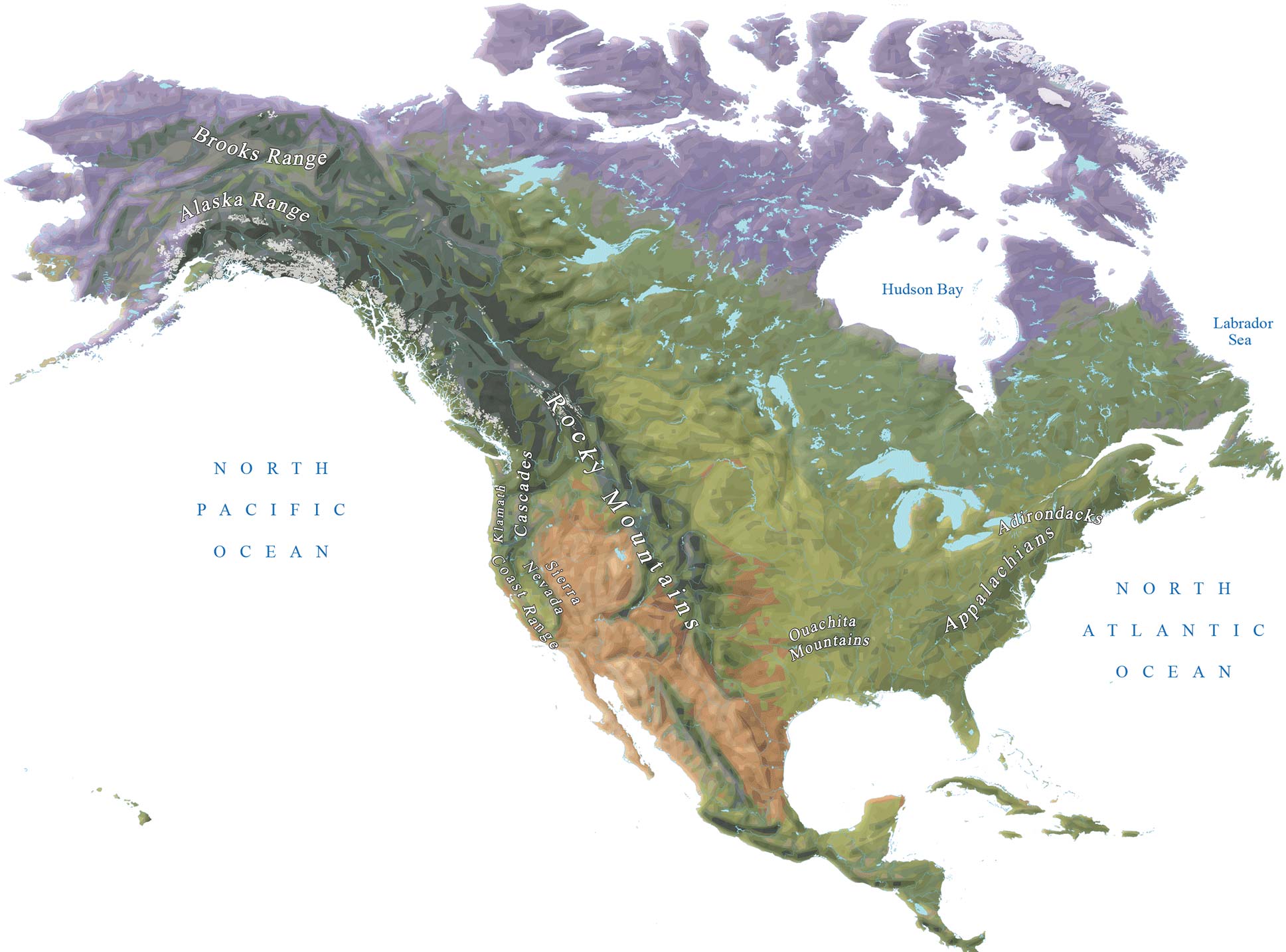
10 US Mountain Ranges Map
You are free to use our US mountains range map for educational and commercial uses. Attribution is required. How to attribute?
10 US Mountain Ranges Map
The United States of America has many diverse landscapes. In fact, it’s home to 300+ major summits over at least 3,000 meters in height. This US mountain ranges map highlights the major mountain ranges in the United States and how they are distributed throughout the country.
Each state has its unique geography. The Appalachian Mountains are the most prominent range in the east. Whereas the Rocky Mountains are in the central USA. Finally, the Sierra Nevada and Cascade Mountains are in the west. The majority of its highest peaks are located in the states of Colorado, Alaska, and California.
This US mountain ranges map is perfect for identifying where your favorite mountaintop is located and which states it’s in. It also briefly describes each range and some interesting facts about them.
READ MORE: Physical Map of the United States
1. The Rocky Mountains
The Rocky Mountains are a mountain range in the western United States. For as long as 3,000 miles (4,800 km), they stretch from New Mexico in the south through British Columbia and Alberta, Canada, to Alaska in the United States.
Its most prominent peak is Mount Elbert, located in the state of Colorado in the Sawatch Range. The Rocky Mountains are known as the Canadian Rockies in Canada with Mount Robson as its highest peak.
They are also one of the most beautiful natural wonders that embody American values of ruggedness and independence. The Rocky Mountains have been a part of American life for centuries and are home to Rocky Mountain National Park.
| Length | 3,000 miles (4,800 km) |
| States/Provinces | British Columbia, Alberta, Washington, Idaho, Montana, Wyoming, Utah, Colorado, and New Mexico |
| Highest Peak | Mount Elbert (4,401 m/14,440 ft) |
2. The Appalachians
The Appalachian Mountains are the longest mountain range in eastern North America. The Appalachians start near the Canada-United States border in New Brunswick and Nova Scotia. Then, they extend southwards to the northern limits of Alabama.
The Appalachians have been called “the backbone of North America”. This is because of their geographic and cultural importance to much of the continent. For years, this region has been popular among hikers, climbers, and campers because of its beautiful scenery.
When you visit this region, you will find a range of natural wonders to experience. One of the most notable is the Appalachian Trail. But you’ll also find waterfalls, lakes, rivers, and its subranges including:
- The Great Smoky Mountains
- Blue Ridge Mountains
- Green Mountains
- White Mountains
- Longfellow Mountains
- The Berkshires
| Length | 2,000 miles (3,200 km) |
| Provinces | Newfoundland and Labrador, Quebec, Nova Scotia, and New Brunswick |
| States | Maine, New Hampshire, Vermont, Massachusetts, Connecticut, New York, New Jersey, Pennsylvania, Maryland, Washington, D.C., Delaware, Virginia, West Virginia, Ohio, Kentucky, Tennessee, North Carolina, South Carolina, Georgia and Alabama |
| Highest Peak | Mount Mitchell (6,684 ft/2,037 m) |
3. Cascade Range
The Cascade Range is a mountain range that stretches from western Washington to northern Oregon in the United States. The highest summit, Mount Rainier, rises over 14,000 feet above sea level.
It’s a massive system of volcanic peaks, with Mount St. Helens as the most famous and active peak. Over the last million years, this range has experienced volcanic eruptions which have shaped the terrain.
Some of these eruptions were so powerful they blasted enormous amounts of rock and lava into the air. Though beautiful to look at, it can also be dangerous when you’re hiking near them.
| Length | 700 mi (1,100 km) |
| States/Provinces | British Columbia, Washington, Oregon, and California |
| Highest Peak | Mount Rainier (14,411 ft/4,392 m) |
4. Brooks Range
The Brooks Range is a vast region of mountains in the northern United States. It’s located between Alaska and Canada, rising abruptly from the surrounding arctic plains. The range is about 700 mi (1,100 km) long and spans an east-west direction
Its highest peak is Mount Isto which reaches a height of 8,976 ft (2,736 m) above sea level. The range is home to a variety of animals and plants, such as caribou, polar bears, and even musk oxen.
| Length | 700 mi (1,100 km) |
| States/Provinces | Alaska and Yukon |
| Highest Peak | Mount Isto (8,976 ft/2,736 m) |
5. Sierra Nevada
The Sierra Nevada stretches along the border between California and Nevada. This mountain range contains several of America’s most popular national parks. This makes it one of the most visited mountain ranges in the country.
The Sierra Nevada Mountains are home to spectacular surrounding landscapes and breathtaking views. Although it’s not the biggest mountain range, it’s home to three national parks. Yosemite, Sequoia, and Kings Canyon are perfect for camping, hiking, and snowshoeing.
| Length | 400 miles (640 km) |
| States/Provinces | California and Nevada |
| Highest Peak | Mount Whitney (14,505 feet/4,421m) |
6. Alaska Range
The Alaska Range is a long, narrow mountain range in North America. It stretches from northwestern Canada to the southern end of the Bering Sea. You can find Denali (Mount McKinley) here. This is North America’s highest peak at 6,190 meters (20,310 feet).
For centuries, Alaska has been sought after for its natural resources and beauty. Many people visit this mountain range because of its historical significance. Other notable mountains here are Mount Foraker, Hunter, and Hayes. They are known for their volcanoes, ice fields, and glaciers.
| Length | 400 miles (640 km) |
| States/Provinces | Alaska |
| Highest Peak | Denali (20,310 ft/6,190.5 m) |
7. Coast Ranges
The Coast Ranges is between the Pacific Ocean, Cascade, Sierra Nevada, and Klamath mountain ranges in California. This range is a series of rugged mountains that stretch for about 400 miles (644 km) along the coast.
Peaks sometimes rise over 8000 feet and sea cliffs drop hundreds of feet to the ocean below. The coastal forests are lush and green, with open woodland at lower elevations. The Coast Ranges offer an incredible variety of habitats for plant life and animals.
| Length | 400 miles (640 km) |
| States/Provinces | California |
| Highest Peak | Mount Linn (Elevation 8,098 ft/2,468 m) |
8. Adirondacks
The Adirondacks is a scenic area in upstate New York that encompasses 5,000 square miles (13,000 sq km) of land. The mountains and hills that surround it provide a view of Lake George, which sits in the east of the range. Adirondack Park has wildlife that includes, moose, black bears, coyotes, and river otters.
The Adirondacks are also home to several lakes. Lake Champlain and Great Sacandaga Lake give you a chance to camp, swim, and fish. Plus, this hiking trail takes you on a journey through some of the most beautiful scenery in America.
The Adirondack Mountains rise sharply from the lakeshore. Peaks reach elevations exceeding 5,000 feet (1,500 m). The range runs roughly north-south. It’s bisected by the Hudson River which flows south through part of it. A considerable amount of this wilderness also covers parts of Vermont as well as portions of Quebec.
| Area | 5,000 square miles (13,000 sq km) |
| States/Provinces | New York |
| Highest Peak | Mount Marcy (5,344 ft/1,629 m) |
9. Ouachita Mountains
The Ouachita Mountains are a mountain range in northwestern Arkansas and southeastern Oklahoma. The highest point is Magazine Mountain at 838 meters (2,753 ft), located in Mount Magazine State Park. The Ouachitas make up part of the southern edge of the Ozark Plateau.
The mountains are named after the Ouachita Tribe who inhabited the area before European contact. The Ouachita Mountains take travelers through the heart of Arkansas and Oklahoma. Its grandeur is a sight to behold with its cliffs, canyons, and waterfalls.
| Length | 160 miles (260 km) |
| States/Provinces | Arkansas and Oklahoma |
| Highest Peak | Magazine Mountain (2,753 ft/838 m) |
10. Klamath Mountains
The Klamath Mountains are a range in the far northwest of California and the south end of Oregon. These mountains include its highest point within the range, Mount Eddy, at 9,025 ft (2,751 m).
Located at the border of California and Oregon, the Klamath Mountains span about 155 miles (250 km) north-south and about 112 miles east-west (180 km). The total area is about 9,880 square miles (25,595 sq km).
| Length | 155 miles (250 km) |
| States/Provinces | Oregon and California |
| Highest Peak | Mount Eddy (9,025 ft/2,751 m) |
US Mountain Ranges Map
This US mountain ranges map illustrates the major mountains in the United States.
We hope you’ve learned the United States has a diverse topography. Some of its longest mountain ranges are the Rocky Mountains, the Appalachians, and the Sierra Nevada.
Did we miss anything for our US mountain ranges map? Please let us know with a comment below.
Why didn’t you mention the Catskills ?
Where’s the Smoky Mountains?
That’s one we should consider adding. Thanks
Part of Appalachian mountains
You should check out the mountains of far West Texas.
The Chisos are stunning. The Davis and Guadalupes are beautiful.
Two National Parks are based on them. Big Bend National Park contains the Chisos. Guadalupe Mountains National Park containts salt flats, desert, even forests.
Is the map incorrect? Are the Adirondacks spelled “Adrindocks”?
Thanks, I fixed that!
Yes.
Should be Adirondack Mountains. Also referred to as “the Adirondacks.”
Great information for a new group of adventurers.Dont forget to the big “Oh, Oh. (You know what I mean when you get there.) Dont forget a compass and plenty of water. Oh, and bug stuff. The camp will be swarming at dusk. Don’t miss the shawangunks, best climbing on the east coast. (5.2 to 5.13d) The rock is always good and some of the routes set by the founders, like High E and Fat City Direct, are so perfect you’ll feel like you’ve entered into a new realm. Cheers
AZ – There are over 200 mountain ranges in AZ. Just in my area are the Huachuca’s (pronounced Wa chu ka), Dragoons, Mule Mountains, Little Rincon, Dos Cabasas, all in Cochise County and the famous Superstition range in Pinal County. Then there is the Sierra Madre all along the AZ – Mexican border.
The Wichita and Arbuckle ranges in south central to south west Oklahoma are the oldest extent mountains on Earth. Not majestically high, but the rock climbing areas in the Wichitas are among the best in the USA.
No mention of the other giant mountain ranges in Alaska???
Such as the Chugiak Range, the Wrangell Range, and the St Elias Range. some of these have over 16,000′ peaks. the St Elias range has 9 of the 16 highest peaks in North America alone.
How did the Adirondacks even get mentioned in the same article? laughable.
Yes, you’re correct. I have some of those mountain ranges and peaks in this map – https://gisgeography.com/alaska-map/
In the highlands of the dash mountains, temperature and precipitation vary.
Mountain Range in Michigan?
Nice to know that the Rincon mountains at 8600 feet behind my house in Arizona and the Cataline Mountains also in Tucson, AZ are actually not mountains? Then, what are they?
Hills
Cascade Range spans from Mt Lassen California in the south and up into British Columbia to the north.
Nice map and concise but informative summaries.
What are the mountains In Arizona?
What about the mountain from the Game of Thrones?
That was filmed mostly in Northern Ireland.
Tehachapi Mountains in California separate North from Southern California and have got to be higher than the range listed in Oklahoma.
I thought the Ozark Mountains were considered a mountain range. The St. Francois Mountains, which are part of this range, date to over 1.4 billion years ago, making them much older than the Appalachians (460 million years) and the Rockies (70 million years). The highest peak in the Ozarks is Buffalo lookout at 2,561 ft. The Ouachita Mountains, which formed over 300 million years ago, are a continuation of the much longer and older Ozark mountain range. 🤷🏻♂️
Wichita Mountains near Lawton Oklahoma.
A cool fact is that these run east/west unlike many others which run north-south.
Black Hills, South Dakota; Ozarks
Mountain ranges in Arizona?
Olympic Mountains in Wa?