US Regions Map
US Regions Map
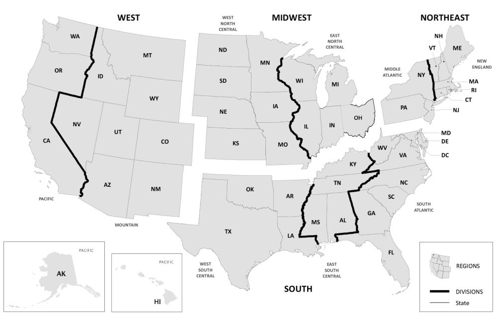
This US Regions map displays the four regions and nine divisions of the United States. The US Census Bureau divides the United States into 4 distinct regions.
From regions 1 to 4, the US Census regions consist of the following – (1) the Northeast, (2) the Midwest, (3) the South, and (4) the West.
As the census occurs every ten years, the US Census Bureau uses this US Regions map to better understand the country’s makeup of the country’s population.
They can also perform further analysis into each division to determine the demographic information and economic activity related to each different geographic division.
Jump To: Northeast Region | Midwest Region | South Region | West Region
Region 1 – Northeast Region
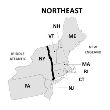
Situated on the Atlantic coast, this region is home to some of the largest cities in the United States such as New York City, Boston, and Philadelphia.
Not only is the Northeast Region the most economically developed region, but it’s also the most densely populated with the least area.
New England (Division 1) contains the states of Connecticut, Maine, Massachusetts, New Hampshire, Rhode Island, and Vermont. Whereas the Middle Atlantic (Division 2) has only 3 states, which include New York, Pennsylvania, and New Jersey.
| Region | States |
|---|---|
| New England (Division 1) | Connecticut, Maine, Massachusetts, New Hampshire, Rhode Island, and Vermont |
| Middle Atlantic (Division 2) | New York, Pennsylvania, and New Jersey |
Region 2 – Midwest Region
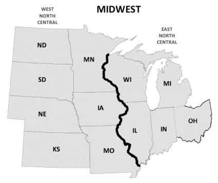
The Midwest Region is home to many major U.S. cities, including Chicago, Detroit, and Minneapolis.
Known for its vast plains, the Midwest Region is the most widely spread out of all the regions and includes 12 different states.
The East North Central (Division 3) contains the states around Lake Michigan including Indiana, Illinois, Michigan, Ohio, and Wisconsin. Whereas the West North Central (Division 4) consists of the states of Iowa, Kansas, Minnesota, Missouri, Nebraska, North Dakota, and South Dakota.
Region 3 – South Region
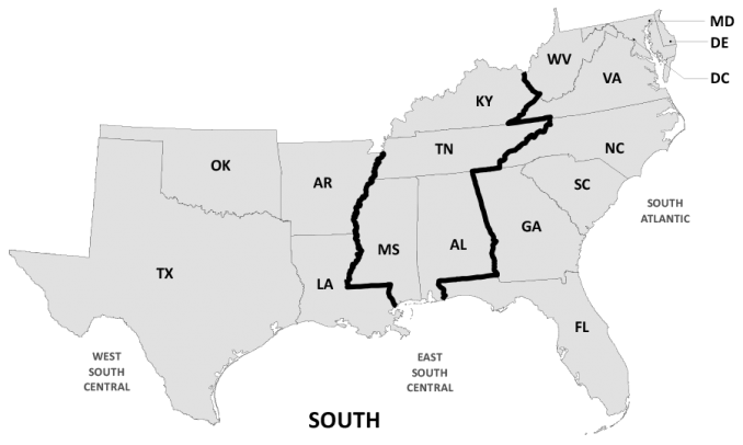
Located in the southeast of the United States, the South Region consists of 17 states, which is the most of all regions. It’s also the only region with 3 divisions, as the others only have 2. With major cities like Dallas, Houston, Washington DC, Miami, and Atlanta, the area is known for its diverse cultures and warm climates.
The South Atlantic (Division 5) contains the states of Delaware, the District of Columbia, Florida, Georgia, Maryland, North Carolina, South Carolina, Virginia, and West Virginia. Altogether, this is the highest number of states within a division.
The East South Central (Division 6) consists of Alabama, Kentucky, Mississippi, and Tennessee. Similarly, the West South Central (Division 7) holds 4 states including Arkansas, Louisiana, Oklahoma, and Texas.
| Region | States |
|---|---|
| South Atlantic (Division 5) | Delaware, District of Columbia, Florida, Georgia, Maryland, North Carolina, South Carolina, Virginia, and West Virginia |
| East South Central (Division 6) | Alabama, Kentucky, Mississippi, and Tennessee |
| West South Central (Division 7) | Arkansas, Louisiana, Oklahoma, and Texas |
Region 4 – West Region
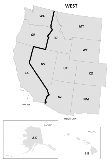
The West Region is the largest region that covers nearly half of the land area in the United States. It sweeps a broad area and includes the Rocky Mountains, and the Pacific Coast to the west, as well as the states of Alaska and Hawaii.
It’s also situated west of the Mississippi River with major cities like Los Angeles, Phoenix, and Denver. It also includes San Francisco and Seattle, which and are home to some of the largest technology companies in the world.
Mountain (Division 8) contains the eight following states just to the east of the Pacific coast – Arizona, Colorado, Idaho, New Mexico, Montana, Utah, Nevada, and Wyoming. Whereas Pacific (Division 9) is characterized by the coastal states of Alaska, California, Hawaii, Oregon, and Washington.
| Region | States |
|---|---|
| Mountain (Division 8) | Arizona, Colorado, Idaho, New Mexico, Montana, Utah, Nevada, and Wyoming |
| Pacific (Division 9) | Alaska, California, Hawaii, Oregon, and Washington |
Thank you for these resources. I would like to use these to help my student prepare for regional state identification tests. I understand that I should cite the source.
These regional maps are very easy to read and makes learning where the states are so much easier.
Thanks again.
Hello, I would like to print the regions to help students to learn the states. It happens that we are learning them by regions. Thanks
Yes, we don’t have any issues with you printing this out
My List of Best US States
Top 3 1st-3rd New York, Florida, Connecticut
Top 5 4th-5th New Mexico, Ohio
Part 2 next
Looks like Maine was dropped from the maps.
Thanks, I fixed both maps with Maine in it. That includes the main map of US regions, and the Northeast Region map.
I didn’t like New Jersey but I only like New Jersey a little bit because it’s in the same region as New York which is where I live in.
But why is Pennsylvania here I don’t know why But Also Florida I think that Florida is (41st) in safest USA states And (9th) in Dangerous USA state because of tornadoes in Disney land in Florida.
NORTHEAST-NY,PA,VT,NH,ME,MA,RI,CT,NT
SOUTH-MS,AL,TS,KY,OK,AR,TX,LA,SC,GA,FL,VA,DC,NC,WV
WEST-WA,OR,CA,ID,MT,WY,UT,NV,AZ,CO,NM
MIDWEST-SD,ND,NE,KS,IA,MO,MN,WI,IL,IN,MI,OH